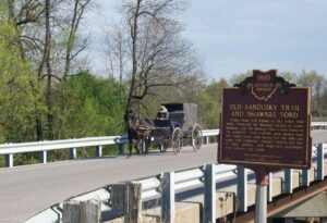
County Road 265 follows an old Indian trail which connected the Wyandot villages at Upper Sandusky with the Shawnee Mac-o-chee towns to the southwest. Many wigwams were pitched near this Scioto River ford during the late 18th and early 19th centuries. Soldiers (during the War of 1812), settlers, and stagecoach passengers later followed this route.
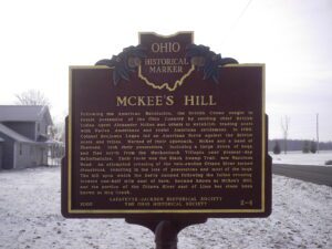
Following the American Revolution, the British Crown sought to retain possession of the Ohio Country by sending chief British Indian Agent Alexander McKee and others to establish trading posts with Native Americans and resist American settlement. In 1786, Colonel Benjamin Logan led an American force against the British posts and tribes. Warned of their approach, McKee and a band of Shawnee, took their possessions, including a large drove of hogs, and fled north from the Mackachack Villages near present-day Bellefontaine. Their route was the Black Swamp Trail, now Napoleon Road. An attempted crossing of the rain-swollen Ottawa River turned disastrous, resulting in the loss of possessions and most of the hogs. The hill upon which the party camped following the failed crossing, located one half mile east of here, became known as McKee’s Hill, and the portion of the Ottawa River east of Lima has since been known as Hog Creek.
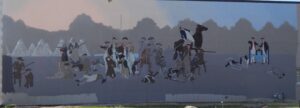
Native Americans inhabited and used much of the land in the Ohio valley as hunting grounds. As American settlers pushed west, conflicts resulted and attempts at peaceful settlement failed. Under political pressure, President George Washington resolved to subdue Indian resistance to American expansion in the Ohio country and appointed General Arthur St. Clair to lead the expedition. St. Clair’s troops camped on the Wabash River (just east of the Ohio-Indiana state line) after an exhausting two-month trek. The ill-prepared soldiers were no match for the forces of Miami, Shawnee, and Delaware Indians who attacked them at dawn of November 4, 1791. By the day’s end, warriors led by Little Turtle and Blue Jacket had killed or wounded nearly three-quarters of the American force-the worst-ever defeat of the U.S. Army by Native Americans in a single battle.
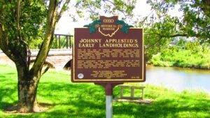
This is the site of Johnny Appleseed’s earliest known recorded landholdings. Appleseed (whose legal name was John Chapman) purchased two parcels from Joseph Walker on September 14, 1809: Mount Vernon town lot 147, upon which you stand, and lot 145, which is across the road and north of this site. Johnny Appleseed likely rested here on August 10, 1813, after arriving from Mansfield with alarming news of a rumored Indian attack. Appleseed returned to Mansfield with reinforcements from Mount Vernon that same day–a round trip of over fifty miles.
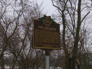
General William Henry Harrison ordered the construction of Fort Winchester at the beginning of October 1812 and it was completed October 15. The fort served as a forward observation post and supply depot for the American army during the War of 1812. Until Fort Meigs was completed in 1813, Fort Winchester was the front line against the British and their Indian allies. During the siege of Fort Meigs, Fort Winchester was a rendezvous point for the troops of General Green Clay and those of Colonel William Dudley. Fort Winchester outlined the shape of a parallelogram, measuring 600 by 300 feet in size. Blockhouses anchored the four corners of the fort and within its stockade were storehouses and a hospital.
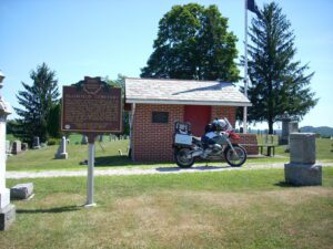
This cemetery, established in 1810, is the final resting place of many of the founders of Plainfield and Linton Township. Besides the early date of its founding, it is notable for the number of armed forces veterans interred here, who represent every major conflict since the Revolutionary War. The graves of eighty-nine Civil War soldiers-a number nearly equal to those of veterans involved in all other wars between the War of 1812 and the Vietnam War-indicate the depth of Plainfield’s involvement in that conflict.
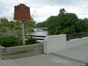
Early in the War of 1812, Gen. Wm. Hull, commander of Ohio troops, ordered Col. James Findlay to open a road from Ft. McArthur on the Scioto River to Blanchard’s Fork. Under Findlay, a stockade 50 yards square, with a blockhouse at each corner, was erected here and named in his honor. The fort was used as a supply depot.
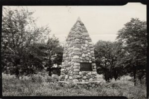
During the Indian Wars of 1790-1795, the United States built a chain of forts in the contested area of what is today western Ohio. These forts were built as a result of various tribes of the region attacking the encroaching American population as they moved north of the Ohio River. In October 1791, General Arthur St. Clair, governor of the Northwest Territory, set out on a mission to punish the tribes and on October 12, ordered his forces to build Fort Jefferson, the fourth link in that chain of forts stretching north from Fort Washington (Cincinnati) to Fort Deposit (Waterville). Each fort was generally a hard day’s march of each other, and the site was chosen because of nearness to a supply of fresh water. The fort was named in honor of Secretary of State Thomas Jefferson.