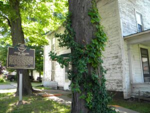
In 1769, Pierre-Louis de Lorimier (Peter Loramie) traveled from Canada to this vicinity to establish fur trading with the local indigenous tribes. This location is a portage between tributaries of the Ohio River and Lake Erie that eased the transport of the quantity of furs in this lucrative trade. His very profitable trading post was located just west of this marker along Loramie Creek. Lorimier’s friendship with the local Shawnee and Delaware tribes, and the British, led him to join them in efforts to curtail the movement of white settlers into the Northwest Territory. In 1782, in an attempt to halt raids along the Ohio River (many of which were formulated at Lorimier’s store), General George Rogers Clark ordered Col. Benjamin Logan to burn Lorimier’s store.
Site of the first fortified settlement in Anderson Township and one of the first in the Virginia Military District. John Garard and Joseph Martin were the founders of this Station, who, with Elias Garard, Joseph Frazee, and others, came by two flatboats with families and livestock from Garards Fort, Pennsylvania, via the Ohio and Little Miami rivers. They landed here on December 23, 1790, and proceeded to erect the fortification.(Continued on other side)
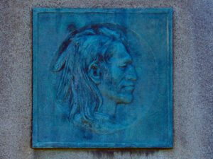
Tah-gah-jute, the Mingo chief named Logan, was a native of Pennsylvania. Logan moved to Ohio in 1770, and settled at the Pickaway Plains. Logan and his father, Shikellimus, had long supported friendships between Native Americans and white men; however, in the spring of 1774, his tribesmen and family were murdered at Yellow Creek, along the Ohio River. Once an advocate of peace, Logan went on the warpath and raided frontier settlements. These and similar raids along the Ohio frontier precipitated Lord Dunmore’s War in October 1774. After the Shawnees and their allies were defeated at Point Pleasant, Virginia governor Lord Dunmore marched up the Hocking River to the Pickaway Plains. Dunmore asked his interpreter, Colonel John Gibson, to assist in negotiations with Cornstalk and other Indian leaders, including Logan. Logan declined to attend the conference, but spoke to Gibson about his anger and betrayal.
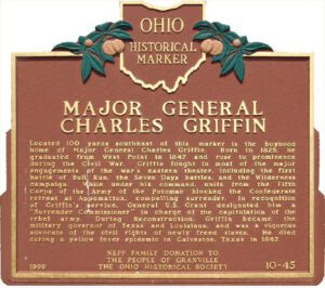
Located 100 yards southeast of this marker is the boyhood home of Major General Charles Griffin. Born in 1825, he graduated from West Point in 1847 and rose to prominence during the Civil War. Griffin fought in most of the major engagements of the war’s eastern theater, including the first battle of Bull Run, the Seven Days battles, and the Wilderness campaign. While under his command, units from the Fifth Corps of the Army of the Potomac blocked the Confederate retreat at Appomattox, compelling surrender. In recognition of Griffin’s service, General U.S. Grant designated him a “Surrender Commissioner” in charge of the capitulation of the rebel army. During Reconstruction, Griffin became the military governor of Texas and Louisiana, and was a vigorous advocate of the civil rights of newly freed slaves. He died during a yellow fever epidemic in Galveston, Texas in 1867.
In 1805, for $1.50 an acre, Jacob Miller purchased this property in the Congressional Land Office in Chillicothe, capital of the new state of Ohio. He and Somerset co-founder John Finck then each built a tavern on either side of town along the Zane’s Trace, laid out along existing Indian trails in 1796-1797 and Ohio’s first major thoroughfare. Finck built his home and tavern in 1807 and Miller his shortly after. From 1800 to 1815, Zane’s Trace saw significant traffic between the established eastern states and the newly opened Northwest Territory. A perpetual stream of emigrants rolled westward, giving constant occupation to hundreds of tavern-keepers. Besides operating his tavern and farming, Jacob Miller was a public servant. In 1809, he was appointed Overseer of the Poor as there was a need to “bind out” poor children to families who could take care of them. [continued on other side]
Union Baptist Church, established in 1819, is one of Ohio’s early Black churches. Its pastor and members were active on the Underground Railroad from that early date. Between the 1840s-1860s Black churches along the route to and from nearby Poke Patch assisted over 200 escaped slaves. Members met in their homes until able to obtain a log cabin (circa 1879) on a Blackfork farm. In 1919, a larger church was built on land given by The Cambria Clay Products Company. The adjacent cemetery has over fifty veterans from the Civil, Spanish American, both World, Korean, and Vietnam wars. Donald Russell Long, laid to rest in 1966, received a posthumous Congressional Medal of Honor. Union Baptist Church, the historic foundation of the Poke Patch-Blackfork community, celebrates an annual Church Anniversary to honor its legacy.
The most notable feature of Mantua Center is the “Village Green,” which harkens back to the New England heritage of Mantua Center’s early settlers. The Green sets upon land donated by Hezekiah Nooney Sr. and was important to both the social and commercial interests of the town. The businesses located here were a furniture and cabinet maker’s shop, harness shop, blacksmith shop, post office, tannery, ashery, dry goods store, and distillery. The Methodist Episcopal Church, now the Mantua Civic Center, stands at the southwest corner of the green. Eastlawn cemetery, with a burial that dates to 1816, sits along the south border. The cemetery serves as the final resting place for soldiers of several wars, including the American Revolution, as well as many other early citizens. In 1835 Horace Sizer constructed the stone wall around the cemetery adjacent to Mantua Center Road. [continued on other side]
The township of Kinsman was purchased by John Kinsman of Lisbon, Connecticut, in 1799 from the Connecticut Land Company. Kinsman has been the home of many notable citizens, some of whom include: Philip P. Bliss (1838-1876) and James McGrannahan (1840-1907) were hymn composers and religious musical directors for the nationally-known evangelical Dwight L. Moody Revival Meetings held in Kinsman for thirty years in the late 1800s. Clarence Darrow (1857-1938) was a famous labor and criminal lawyer who grew up in Farmdale and in the “octagon house” in Kinsman. Darrow in probably best known for his work as a defense attorney in the Scopes Trial. (continued on reverse side)