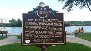
John Baptiste Flemmond (1770-1827), a French Canadian trader, was one of the earliest Euro-American settlers in what became Erie County. In 1805, he established a trading post at “Flemmond’s Cove” on the east side of the Huron River about two miles from its mouth. Flemmond spoke French, English and several American Indian dialects, often serving as an intermediary between new settlers and indigenous peoples. Flemmond wed Elizabeth Pollock in 1811, in what is believed to be the first settler marriage in the Firelands. In the War of 1812, he served in the Northwest Army as a guide and interpreter.
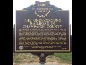
The inhumanity of slavery and the Fugitive Slave Acts of 1793 and 1850 motivated anti-slavery activists to operate a covert network, the “Underground Railroad,” which helped fugitive slaves escape captivity. From the early 1800s to the end of the Civil War, local activists assisted runaway slaves on their journeys north to freedom. Guides (“conductors”) used their homes, farms, and churches (“stations”) to hide and shelter runaway slaves (“cargo.”) If captured, fugitives were severely punished and re-enslaved; “conductors” faced large fines and imprisonment, and Free Persons of Color risked being sold into slavery. A route often-traveled was once a path used by migrating buffalo, which became an Indian trail called the Bullskin Trace. It ran north from the Ohio River to Lake Erie and later became U.S. Route 68.
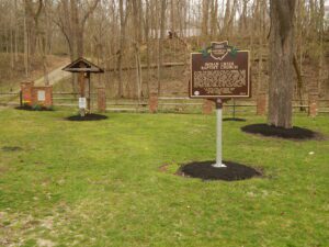
The Indian Creek Regular Baptist Church was established in 1810 as an arm of the Little Cedar Creek Church of Brookville, Indiana. The congregation purchased three acres of land for a burial ground and church and built a log structure here in 1811. Members voted in 1812 that they would receive no person who believed in the principles of slavery. By 1829, membership had reached 150 and the present brick meeting house was built. In the 1840s, membership declined due to conflict over mission activity The congregation dissolved in 1879 and the land was deeded to the Indian Creek Cemetery Association in 1880. The county park system received the property in 1960 through and with the cooperation of the Butler County Historical Society and the Cemetery Association.
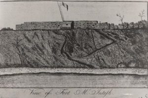
In 1785, American Indian tribal leaders from the Chippewa, Delaware, Ottawa, and Wyandot met with representatives sent by the United States Congress to sign the controversial Treaty of Fort McIntosh. The treaty surrendered control of Native American lands in southern and eastern Ohio to the United States government. Most Indians rejected the validity of the treaty and rather than improving relations, the Treaty of Fort McIntosh only intensified the tensions that existed between the United States government and the Indian tribes. This marker signifies the eastern most portion of the American Indian territory outlined by the treaty. The Portage Path, a trail used by American Indians as a portage between the Cuyahoga and Tuscarawas rivers, became a part of this boundary line.
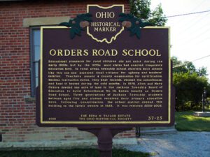
Educational standards for rural children did not exist during the early 1800s, but by the 1870s most states had enacted compulsory education laws. In rural areas, township school districts built schools like this one and assessed local citizens for upkeep and teacher’s salaries. Teachers passed a county examination for certification. Besides instruction duties, they kept records, cleaned the schoolhouse, and kept it heated during the cold months. In 1879, Allen and Mary Orders deeded one acre of land to the Jackson Township Board of Education to build Schoolhouse No. 10, known locally as Orders Road School. Three generations of Jackson Township students between ages five and sixteen received their primary education here. Following consolidation, the school district deeded this building to the farm’s owners in 1928. It was restored in 2000-2002.
Mesopotamia Township, Trumbull County was a part of the Western Reserve, 3.3 million acres in Northeast Ohio claimed by Connecticut. After the Treaty of Greenville extinguished American Indian title in 1795, the state sold most of the land to the Connecticut Land Company (except for the Firelands to the west). The company’s proprietors then sold the land to settlers from Connecticut and the east and they in turn brought to the west their ideas for what a solid home should look like. (Continued on other side)
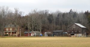
Lewis-Sample Farmstead. The farmstead shares the name of the Lewis and Sample families, two owners since European-descended settlers began moving into the Ohio County in the late 1700s. Andrew (1762-1847) and Martha Lewis (1774-1852) acquired this land in 1804. Like others, Andrew saw for himself the rich land north of the Ohio River while in the army during the Ohio Indian Wars of the 1790s. By 1834, the Lewis farmstead had expanded to more than 350 acres with a brick house, still house, and sawmill on Indian Creek. The Sample family purchased the farm in 1871 and owned it until 2007.
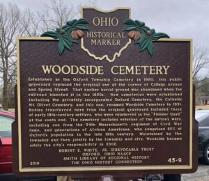
Established as the Oxford Township Cemetery in 1880, this public graveyard replaced the original one at the corner of College Avenue and Spring Street. That earlier burial ground was abandoned when the railroad bisected it in the 1850s. New cemeteries were established including the privately incorporated Oxford Cemetery, the Catholic Mt. Olivet Cemetery, and this one, renamed Woodside Cemetery in 1931. Bodies transferred here from the original graveyard included those of early 19th-century settlers, who were reinterred in the “Pioneer Quad” at the south end. The cemetery includes veterans of the nation’s wars, including one from the 54th Massachusetts regiment of Civil War fame, and generations of African Americans, who comprised 20% of Oxford’s population in the late 19th century. Maintained by the township and then jointly by the township and city, Woodside became solely the city’s responsibility in 2002.