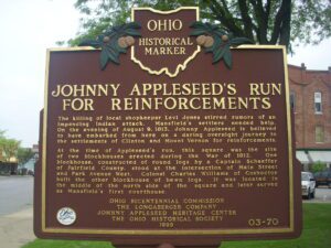
The killing of local shopkeeper Levi Jones stirred rumors of an impending Indian attack. Mansfield’s settlers needed help. On the evening of August 9, 1813, Johnny Appleseed is believed to have embarked from here on a daring overnight journey to the settlements of Clinton and Mount Vernon for reinforcements. At the time of Appleseed’s run, this square was the site of two blockhouses erected during the War of 1812. One blockhouse, constructed of round logs by a Captain Schaeffer of Fairfield County, stood at the intersection of Main Street and Park Avenue West. Colonel Charles Williams of Coshocton built the other blockhouse of hewn logs. It was located in the middle of the north side of the square and later served as Mansfield’s first courthouse.
Mary Ann Ball was born in this vicinity in 1817 and began her nursing career at age 20. When the Civil War broke out in 1861, Mary at the age of 45 went to the soldiers’ aid. Ignoring rank, protocol, and allegiance, she pursued fearlessly and with inexhaustible energy her mission to care for the sick and wounded. Rebel, Union, and Negro soldiers all received the same attention. She risked enemy fire, especially through Grant’s Western Campaign and Sherman’s Georgia Campaign, to rescue suffering men, often going out at night to hunt for the fallen. When the victorious armies of the North were reviewed in Washington at the war’s end, “Mother Bickerdyke” road her faithful white horse beside the generals and colonels. Veterans along the line of march gave her the loudest cheers.
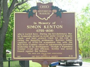
Simon Kenton who is buried here. During the Revolutionary War he frequently served as scout under George Rogers Clark, and later praised Clark for his role in saving the Kentucky settlements. Kenton’s Indian captivity of 1778-79 acquainted him with the Mad River Country where he subsequently provided leadership in its development. Though a legendary frontier scout and rifleman, Kenton was never biased against the Indians.
After American militia troops forcibly ended the 1812 siege of Fort Wayne, General James Winchester’s Army of the Northwest marched down the north side of the Miami [Maumee] River to stop or retard advancing British troops sent to aid in the siege of Fort Wayne. After three days of difficult march, Ensign James Liggett of the 17th Regiment, volunteered to lead a group of four spies or scouts to the site of the old Fort Defiance. Liggett’s small force was surprised and killed on or about September 25 near here. The Americans tried twice to recover the bodies, but met with ambush from hostile Native Americans sympathetic to the British. Their bodies were finally recovered and buried in a common grave. Besides Liggett, they included Wyatt Stepp, Guy Hinton, William Bevis, and Nathaniel Mitchell of Woodford County, Kentucky, all of Captain McCracken’s Company, 1st Rifle Regiment, Kentucky Volunteer Militia.
Acclaimed author and illustrator of juvenile literature Lois Lenski was born in Springfield in 1893, grew up in Anna, and graduated from Sidney High School. In 1915, Lenski graduated from The Ohio State University and moved to New York City to work and study art. After illustrating several children’s books in the early 1920s, she began writing and illustrating her own stories. Lenski specialized in historical fiction and regional themes–eventually publishing nearly one hundred carefully-researched books.
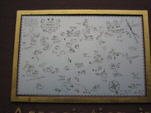
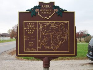
With the signing of the Treaty of Paris in 1783, England lost the American Revolution and ceded to its former colonies land from the Atlantic Ocean to the Mississippi River. By this time, pioneer settlers had reached the eastern bank of the Ohio River, but the Ohio Country, located west and north of the river, was still considered Indian Territory. The Indian tribes desperately defended their hold on this land. On August 20, 1794, United States forces led by Major General Anthony Wayne defeated an Indian alliance at the Battle of Fallen Timbers fought near modern-day Toledo. One year later, on August 3, 1795, the largest assemblage of northwestern Indian representatives at a peace settlement signed the Treaty of Greene Ville, which effectively ceded all land south of the Greene Ville Treaty line to the Americans. The Fort Laurens site was a reference point in the Treaty line. The Ohio Country was then rapidly settled, and in 1808, Tuscarawas County was organized.
SW corner of W Main Street and S Broadway Street (Public Square)
Greenville
, OH
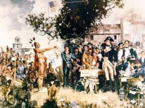
Following General Anthony Wayne’s victory at Fallen Timbers, members of the western tribes assembled at Fort Greene Ville to settle on terms of peace. Representatives of the Wyandot, Delaware, Shawnee, Ottawas, Chippewa, Ottawa, Patawatimi, Miami, Eel River, Wea, Piankeshaw, Kickapoo, and Kaskaskia signed the treaty on August 3, and agreed to cede claims to lands east of the Cuyahoga River to Fort Laurens in Tuscarawas County and south of a line running west to Fort Recovery. In return, the United States offered payment and annuities in the form of goods and ceded claim to most land north and west of the treaty line. This treaty marked the end of the Indian Wars in the Ohio Country, forsaking boundary violations by both parties, and established the official western border of the United States, opening much of Ohio for settlement.
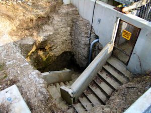
Indian Trail Caverns, first opened in 1927, is one of many caves that occur on the dolomite ridge traversed by State Route 568 in Wyandot and Hancock counties. Sheriden Cave, a karst sinkhole associated with the caverns, was discovered in 1989. It has collected a remarkable record of Ice Age animal and human activity in its sediments. Excavations have revealed remains of many extinct Late Pleistocene Epoch animals-giant beaver, stag moose, flat-headed and long-nosed peccary, and short-faced bear, among many others-that were sealed in the cave by glacial deposits more than ten thousand years ago. Paleo-Indian tools, including projectile points and scrapers, are evidence of the earliest-known human activity in this region.