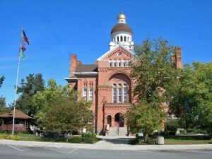
Named for John Paulding, a Revolutionary War soldier whose capture of a British spy implicated Benedict Arnold in treason, Paulding County was formed in 1820 from the last remaining unorganized area of Ohio. Sparsely settled, it remained under the jurisdiction of Wood County until 1824 and then Williams County until 1839. Paulding’s first county seat was established at New Rochester in 1839, then moved to Charloe in 1841. Neither village exists today. Centrally-located Paulding Center became the county seat in 1851, and a courthouse was built the following year. The present courthouse, built during the region’s timber boom of the late 19th century, was designed by architect Edward Oscar Fallis and patterned after his Lenawee County courthouse in Adrian, Michigan. The four-faced Romanesque style building was completed in 1888 at a cost of $40,000. It was listed on the National Register of Historic Places in 1974.
The first War of 1812 battle on Ohio soil was fought here when about 60 exhausted citizen soldiers were ambushed by about 130 Indians on September 29. Twenty men held the Indians at bay from a cabin while the main body escaped by boat to Cedar Point. Two days later the defenders were rescued. Forty Indians including several chiefs and 8 Americans were killed in the skirmish, neither a victory nor a defeat for either side.
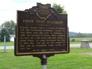
Brigadier General Albert G. Jenkins of Virginia, with 350 Confederate cavalrymen, crossed the Ohio River near this point on September 3, 1862, and advanced to Racine. After occupying the town for a few hours and after seizing a dozen horses, the troops re-crossed the river at Wolf’s Bar. This was the first invasion of Ohio soil by Confederate troops during the Civil War.
Near this site scout Peter Navarre built in 1807 a log cabin close by an Ottawa Indian Village of 60 whitewashed cabins. Here he maintained friendly relations between white settlers and Chief Autokee. The 1833 Treaty of Maumee gave 320 acres of this region to the Indians who later sold the isle for $1,000. Presque Isle is now at the heart of Port of Toledo activity.
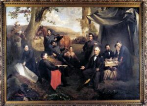
Major Daniel McCook of Carrollton and his 9 sons and their cousins, the 5 sons of Dr. John McCook of Steubenville, won popular acclaim for their outstanding service in the United States Army and Navy. “Tribe of Dan” Maj. Daniel: mortally wounded at Buffington Island. Maj. Latimer: a surgeon. Brig. Gen. George: early regimental commander. Midshipman John: died at sea. Brig Gen. Robert: murdered by guerrillas. Maj. Gen. Alexander: commander of the 20th Corps. Brig. Gen. Daniel Jr. mortally wounded at Kenesaw Mt. Maj. Gen. Edwin: served under Grant and Sherman. Pvt. Charles: killed at Bull Run. Col. John: seriously wounded in Virginia.
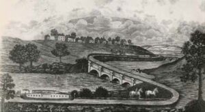
Construction began in 1825 on the 20-mile segment of the Miami Canal from two miles north of Middletown to the head of Mill Creek. Canal boats were operating from Hartwell’s Basin near Cincinnati to Middletown by Nov. 28, 1827. This early link in what became the Miami and Erie Canal joining in 1845 Toledo and Cincinnati by water was restored in 1971 by the Butler County Park district.
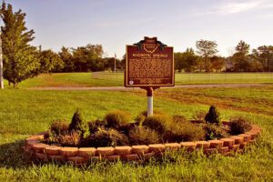
Near this site in 1879, J.E. Newhouse discovered a magnetic spring in his park, Green Bend Gardens. It was found that a knife blade dipped in the water could pick up small metal objects like a magnet. The spring became known for its curative powers and was advertised as a treatment for ailments including rheumatism, gout, insomnia, and diseases of the kidneys, bladder, and nerves. To share the health-giving water, Mr. Newhouse opened the Magnetic Bath House, which became famous for its water cures. To reach a larger market, the magnetic water was sterilized and bottled and sold under the Magnetic Springs label. Advances in medicine after World War II led to the decline in the popularity of mineral baths.
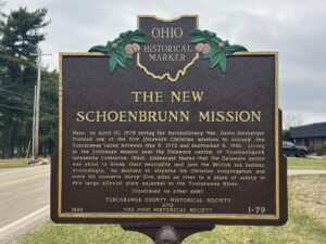
Here, on April 10, 1779 during the Revolutionary War, David Zeisberger founded one of the five Delaware Christian missions to occupy the Tuscarawas Valley between May 3, 1772 and September 8, 1781. Living at the Lichtenau mission near the Delaware capital of Goschachgunk (presently Coshocton, Ohio), Zeisberger feared that the Delaware nation was about to break their neutrality and join the British led Indians. Accordingly, he decided to disperse his Christian congregation and move his converts thirty-five miles up river to a place of safety in this large alluvial plain adjacent to the Tuscarawas River.