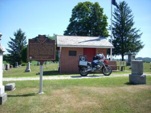
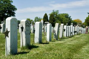
This cemetery, established in 1810, is the final resting place of many of the founders of Plainfield and Linton Township. Besides the early date of its founding, it is notable for the number of armed forces veterans interred here, who represent every major conflict since the Revolutionary War. The graves of eighty-nine Civil War soldiers-a number nearly equal to those of veterans involved in all other wars between the War of 1812 and the Vietnam War-indicate the depth of Plainfield’s involvement in that conflict.
Main Street, across from the Deersville United Methodist Church
Deersville
, OH
Mary Leonore Jobe was born on January 29, 1878, near Tappan, Harrison County, Ohio. She earned a bachelor’s degree from Scio College and master’s degree from Columbia University. While studying, she began a life-long career of exploration and natural history investigation. She first explored areas of British Columbia, Canada in 1905 and in 1916 started Camp Mystic, a summer camp in Connecticut for girls. She married explorer Carl E. Akeley in 1924 and completed an expedition to Africa when Carl died in the Belgian Congo in 1926. Honors include the naming of Mount Jobe in Canada to recognize her achievements and Belgium awarding her the Cross of the Knight, Order of the Crown, for her work in the Belgian Congo. She is known for her books and contributions to the American Museum of Natural History in New York. She died on July 19, 1966, and is buried in Deersville.
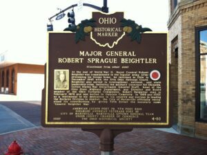
Robert Sprague Beightler was born in 1892 in Marysville. A graduate of Marysville High School, he began his career as a soldier in 1911, when he enlisted as a private in Marysville’s guard unit, Company E, Fourth Ohio Infantry Regiment. He served in Mexico from 1916-1917, World War I from 1917-1919, and World War II from 1940-1945. From his stint with the Ohio Infantry, he rose in rank to command the famous 37th Ohio National Guard Buckeye Division as Major General during WWII. Beightler was one of the most successful National Guard Generals and the only National Guard General to lead his troops through both training and combat in WWII. He was with his troops through 700 days of fighting in the South Pacific Theater. Fighting occurred on Bougainville Island and in the islands of New Georgia and the Philippines. (Continued on other side)
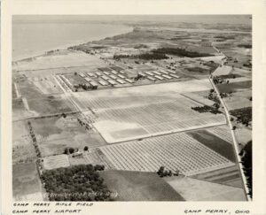
In an effort to improve the marksmanship of Ohio soldiers, Adjutant General Ammon B. Critchfield established Camp Perry, an Ohio National Guard Military Training site on the shore of Lake Erie in 1906. Camp Perry was named after Commodore Oliver Hazard Perry, who defeated British forces in the Battle of Lake Erie during the War of 1812. This particular location was ideal for shooting ranges because varying-length ranges were able to share a common firing line, and shooting practice could take place on all ranges, without the added risk of stray bullets. (continued on other side)
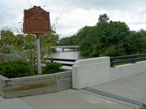
Early in the War of 1812, Gen. Wm. Hull, commander of Ohio troops, ordered Col. James Findlay to open a road from Ft. McArthur on the Scioto River to Blanchard’s Fork. Under Findlay, a stockade 50 yards square, with a blockhouse at each corner, was erected here and named in his honor. The fort was used as a supply depot.
After the War of 1812, the United States Congress proposed two million acres of military bounty land for the Michigan Territory. To survey the land, the meridian had to first be established. U.S. Surveyor General Edward Tiffin created the meridian based on the western line of the Treaty of Detroit (1807). He contracted with Deputy Surveyor Benjamin Hough in April 1815 to begin the survey for $3 per mile. Taking a reading from Polaris (the North Star), Hough, Alexander Holmes, and 11 crew members surveyed the line due north from Fort Defiance. The difficult terrain they encountered temporarily halted all surveys in the territory and ultimately led to the bounty land being transferred to the Illinois and Missouri Territories.
In 1884 the Ohio General Assembly authorized “the burial of the body of any honorably discharged union soldier, sailor or marine of this state who shall hereafter die without leaving means sufficient to defray funeral expenses.” Permanent government-issued headstones have been provided to veterans since the late 19th century. Between 1884 and the 1930s, Washington Cemetery buried 47 white soldiers (including 15 unknown) and 35 African-American soldiers. These veterans served in the Civil War, the Spanish-American War, and WWI. They are remembered for the sacrifices they made. In the fall of 2001, the cemetery underwent significant renovations, in which students of the Washington Senior High School Research History program aided in identifying the buried soldiers and restoring and replacing the gravestones. Here in Soldiers’ Row, the words of local United States Colored Troops veteran, Albert Bird, echo centuries later: “We have suffered to save the country; we ought to be remembered.”
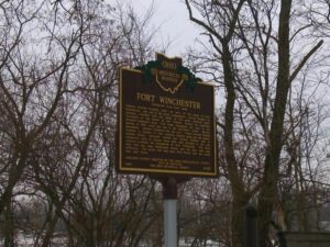
General William Henry Harrison ordered the construction of Fort Winchester at the beginning of October 1812 and it was completed October 15. The fort served as a forward observation post and supply depot for the American army during the War of 1812. Until Fort Meigs was completed in 1813, Fort Winchester was the front line against the British and their Indian allies. During the siege of Fort Meigs, Fort Winchester was a rendezvous point for the troops of General Green Clay and those of Colonel William Dudley. Fort Winchester outlined the shape of a parallelogram, measuring 600 by 300 feet in size. Blockhouses anchored the four corners of the fort and within its stockade were storehouses and a hospital.