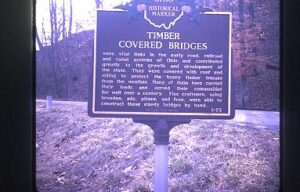
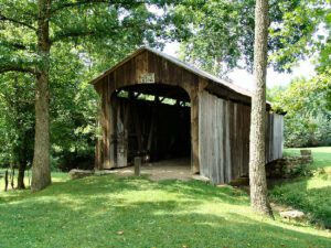
This bridge, spanning Brush Creek in Brush Creek Township, Scioto County, was erected in 1874 by the Smith Bridge Company of Toledo, Ohio. Robert W. Smith was granted patents for timber trusses in 1867 and 1869, and the design for this bridge is a Smith patented truss. The supplemental arches were added in 1896. Original length of 200 feet had been shortened to its present 171 feet. This plaque has been erected to give due honor to these early timber covered bridge builders and to the men of the community who so ably assisted them. [This side of the marker contains a bridge illustration in the upper left corner]
This covered bridge, spanning Salt Creek in Perry Township, Muskingum County was erected in the 1870s. It is a splendid example of an Ohio covered bridge built with Warren type trusses. It is being preserved as an important illustration of the sound, fine craftsmanship of the early bridge builders of Ohio. This plaque has been erected to give these men the honor they greatly deserve.
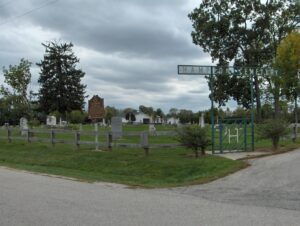
On September 8, 1803, the year that Ohio became a state, the Associate Judges of Franklin County ordered that a road be constructed “leading from the Public Square in Franklinton to Springfield, Greene County.” This road came to be known as The Old State Road or Ludlow’s Road. On this spot in the summer of 1822, the Village of New Hampton was laid out, the road being Main Street of the village. New Hampton was the forerunner of West Jefferson. It fell into oblivion eight to nine years later when West Jefferson was developed along the National Road. All that remains of New Hampton is the cemetery and this part of the road.
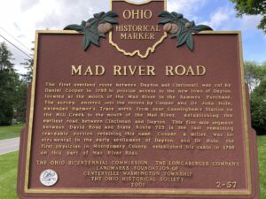
The first overland route between Dayton and Cincinnati was cut by Daniel Cooper in 1795 to provide access to the new town of Dayton, located at the mouth of the Mad River in the Symmes Purchase. The survey, entered into the record by Cooper and Dr. John Hole, extended Harmer’s Trace north from near Cunningham’s Station on the Mill Creek to the mouth of the Mad River, establishing the earliest road between Cincinnati and Dayton. This five-mile segment between David Road and State Route 725 is the last remaining traceable portion retaining this name. Cooper, a miller, was instrumental in the early settlement of Dayton, and Dr. Hole, the first physician in Montgomery County, established his cabin in 1796 on this part of Mad River Road.
The first overland route between Dayton and Cincinnati was cut by Daniel Cooper in 1795 to provide access to the new town of Dayton, located at the mouth of the Mad River in the Symmes Purchase. The survey, entered into the record by Cooper and Dr. John Hole, extended Harmer’s Trace north from near Cunningham’s Station on the Mill Creek to the mouth of the Mad River, establishing the earliest road between Cincinnati and Dayton. This five-mile segment between David Road and State Route 725 is the last remaining traceable portion retaining this name. Cooper, a miller, was instrumental in the early settlement of Dayton, and Dr. Hole, the first physician in Montgomery County, established his cabin in 1796 on this part of Mad River Road.
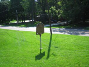
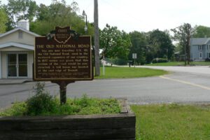
You are now traveling U.S. 40, the “Old National Road” used in the westward expansion of our country. In 1837 notice was given that this section of the road would be constructed. A toll house was located at the east edge of Brandt.
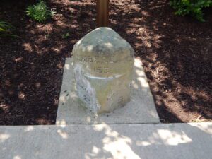
The earliest highway signs along the National Road (Route 40) in Ohio were milestones located at one-mile intervals along the north side of the roadway. Each stone indicated the distance to Cumberland, Maryland, the eastern terminus of the National Road, and to the nearest cities and villages for both east and westbound travelers.
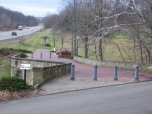
Coaches, Conestoga wagons, herds of livestock, pioneers on horseback, peddlers, soldiers, beggers–these and many others have crossed this bridge on the National Road since 1830. Escaping slaves sought shelter beneath it. Like many others on the road, the bridge was built with well-cut stone and good mortar in the shape of an “S” because it was easier to erect than one thrown straight across an oblique stream.