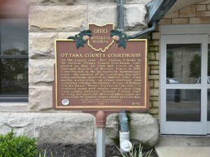
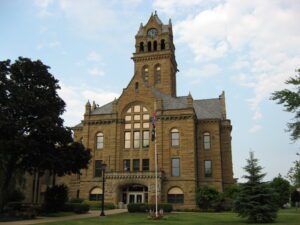
As the county seat. Port Clinton is home to the present Ottawa County Courthouse, completed on May 20, 1901 and listed on the National Register of Historic Places in 1974. Constructed in the Richardson Romanesque style, the exterior of the courthouse was built using sandstone quarried at Amherst, Ohio. Pink marble wainscoting, an ornate staircase, and stenciling enhance the interior. A copy of William Powell’s mural, “Perry’s Victory on Lake Erie,” is featured along with smaller murals depicting early county industries–farming, fishing, fruit growing, and quarrying. Memorial tablets honor veterans from the Spanish-American War and Civil War.
Anson Williams visited Ohio in 1834 before he moved to Orange Township. A former resident of New York State, Williams purchased this site and the surrounding 1,000 acres of U.S. Military District lands and hoped to find opportunity for himself and his family. He bought the land for $6.00 an acre from James D. Wolf, who owned the 4,000-acre section three of Orange Township. The Village of Williamsville was laid out with 80 lots in 1836 on both sides of the Columbus and Sandusky Turnpike. Williams built his home and a hotel with a store and tavern. A hotel and tavern, owned by George Gooding and where the stage changed horses, had already been established north of Williamsville. Competition may have led to Williamsville’s decline. A church was built in 1845 and remained until 1900. Anson died in 1847, and his wife Hannah passed away in 1851. Both are buried in nearby Williamsville Cemetery.
Ohio Columbus Barber began construction of his farm complex in 1909; Barn No. 1 was the first structure. The farm, named for his daughter and son-in-law, ultimately encompassed 3500 acres and 102 structures. It was famous for both the design of its buildings and its scientific agriculture. Listed on the National Register of Historic Places, Barn No. 1 was renovated in 1985 by Yoder Brothers, Inc., for their world headquarters.
In 1873, Tiffin’s Cronise sisters became the first women admitted to the Ohio Bar. At that time, Ohio laws did not provide for the admission of women attorneys. On April 4th 1873, Nettie Cronise applied to the district court. Despite vigorous opposition, leading local attorneys, including William Harvey Gibson and George Seney, supported Nettie’s applications. Ironically, at the same time as Nettie’s admission, the U.S. Supreme Court affirmed Illinois’ denial of admission to the bar to another woman based upon gender. Regardless, Nettie opened the door for the admission of women to the bar of Ohio. Six months later, Florence, Nettie’s younger sister, was admitted. Florence was also the first female notary public in the state. Together the sisters opened the first female-owned law practice in Ohio, N. & F. Cronise. (Continued on other side)
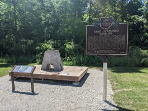
The Ohio Standard Baseline (OSB) was a geodetic baseline that provided highly accurate measurements of the earth and made possible extremely fine calibrations of surveying equipment. Several such baselines were established in Europe and South America during the mid-twentieth century, specifically designed to use a measurement device called the Vaisala Comparator, a precursor of modern laser light measurement systems. In 1953, Dr. T.J. Kukkamaki, then a professor in the Department of Geodetic Science at The Ohio State University, proposed establishing a baseline in Ohio that would be part of the worldwide efforts to accurately understand how the size and shape of the earth change over time. Built between 1965 and 1966, the resulting OSB consisted of a series of eight concrete pillars supporting mirrors and instruments, spaced along a 500 meter distance. (Continued on other side)
As the county seat, Port Clinton is home to the present Ottawa County Courthouse, completed on May 20, 1901 and listed on the National Register of Historic Places in 1974. Constructed in the Richardson Romanesque style, the exterior of the courthouse was built using sandstone quarried at Amherst, Ohio. Pink marble wainscoting, an ornate staircase, and stenciling enhance the interior. A copy of William Powell’s mural, “Perry’s Victory on Lake Erie,” is featured along with smaller murals depicting early county industries – farming, fishing, fruit growing, and quarrying. Memorial tablets honor veterans from the Spanish-American War and Civil War.
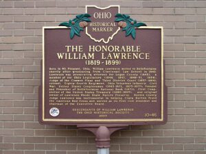
Born in Mt. Pleasant, Ohio, William Lawrence moved to Bellefontaine shortly after graduating from Cincinnati Law School in 1840. Lawrence was prosecuting attorney for Logan County (1845); a member of the Ohio Legislature (1846, 1847, 1849-51, 1854); Judge of the Common Pleas and Third District Court (1857-1864); colonel, Eighty-fourth Regiment, Ohio Volunteer Infantry, Civil War; United States Congressman (1865-1871, 1873-1877); Founder and President of Bellefontaine National Bank (1871); First Comptroller of the United States Treasury (1880-1885); and original owner of Lawrence Woods State Nature Preserve, Hardin County. Judge Lawrence was instrumental in helping Clara Barton found the American Red Cross and served as its first vice president and chairman of the Executive Board.
When inventor and entrepreneur Garrett Augustus Morgan sold his Traffic Signal patent to General Electric in 1923, he used the $40,000 to purchase a 121-acre farm in Huron County in 1924. Advertising “a village of our own,” Morgan established the Wakeman Country Club — one of Ohio’s early African American recreation clubs — and offered 247 lots for $60 each in “Wakeman Heights.” Located near the intersection of State Route 60 and Chenango Road, the development provided country pleasures to Blacks excluded from the Country Club lifestyle. Club membership, included in the purchase of a lot, offered fishing, hunting, swimming, and horseback riding. A restaurant, dance hall, and amphitheater provided cultural and boxing events. The club waned during World War II and no buildings from the once-thriving Wakeman Country Club remain.