The first Blaine Hill Bridge was constructed in 1828 as part of the National Road, the nation’s first federally funded highway. This three-arch S-shaped structure, 345 feet in length, spans Wheeling Creek (a tributary of the Ohio River) and is the longest original “S” bridge in existence on the old National Road. At a gradient of approximately 6.3 percent from east to west, it significantly eased, for the first time, the arduous 500-foot western climb out of the valley. Crumbling and in poor condition, it was saved from demolition in 1999 and in 2001 was designated Ohio’s official Bicentennial Bridge. Now tucked between the 1933 U.S. 40 viaduct and Interstate 70, it illustrates the earliest of Ohio’s three eras in national highway transportation.
Unsatisfied by the terms of the treaty that ended the French and Indian War, Ottawa chief Pontiac led a confederacy of Native American tribes in attacks against British frontier forts during 1763, a campaign known as “Pontiac’s Conspiracy.” In October 1764, Colonel Henry Bouquet led a 1500-man army into the Ohio country from Fort Pitt (present-day Pittsburgh) as a demonstration of British force and to free captives held by several tribes. Informed of possible attack, Bouquet diverted his army overland from his Tuscarawas River valley route and here deployed his forces into three lines: a group of scouts on each ridge and the main force along present Route 93. Evidence of artillery emplacements and infantry breastworks remained visible for many years.
Established in 1879 by Chicago industrialist William P. Rend as a coal mining town, Rendville became a place where African Americans broke the color barrier. In 1888, Dr. Isaiah Tuppins, the first African American to receive a medical degree in Ohio, was elected Rendville’s mayor, also making him the first African American to be elected a mayor in Ohio. Richard L. Davis arrived in Rendville in 1882 and became active in the Knights of Labor. He was one of the labor organizers from the Little Cities of Black Diamonds region who helped found the United Mine Workers of America in 1890. An outstanding writer and orator, Davis was elected to UMWA’s national executive board and organized thousands of African Americans and immigrants to join the union. (continued on other side)
Veteran’s Park, S triangle of OH 66 & Washington Avenue
Piqua
, OH
Local views on the Vietnam War mirrored national attitudes of pride and confusion. Piqua citizens participated in the “Letters for Life” campaign in 1970 for prisoners of war. Piqua Daily Call assistant news editor James W. DeWeese traveled to Paris in a frustrated attempt to deliver the letters to the Hanoi Peace delegation. The state activated the local Ohio National Guard unit in 1970 to help suppress anti-Vietnam student rioting in Columbus. The military conflict came home in 1966 when William Pitsenbarger became the first of eleven men from Piqua to die in Vietnam. In 1967, Piqua High School graduate Air Force Major William J. Baugh was shot down over North Vietnam and taken prisoner. He remained a P.O.W. until 1973.
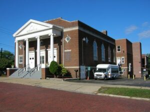
This church, founded in 1866, is the oldest Black congregation in Akron. After worshiping in several locations, the congregation held a fund-raiser to help finance the construction of a permanent home. The person collecting the most money had the privilege of renaming the church. That honor went to Mrs. Belle (Smith) Wesley. Completed in 1928, the current structure is a Neo-Classical Revival style building, featuring a classical pedimented portico, or porch, and four distinctive ionic columns. An education wing was added in 1963 by the late Rev. Dr. E. E. Morgan, Jr. Akron Black architects Herbert L. Wardner and John O. Somerville designed the church, and then a Black contractor, Samuel Plato, completed the structure. The church has long been a vital religious and social focal point for Akron’s Black community. The local chapter of the National Association for the Advancement of Colored People (NAACP) was organized at Wesley Temple. Placed on the National Register of Historic Places 3/19/94.
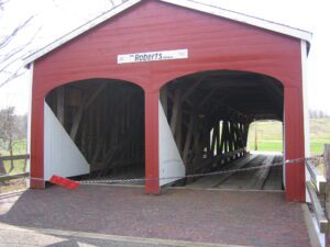
This covered bridge in the oldest still (1962) standing in the state and the last of the “double-barreled” spans in Ohio. It was built across Seven Mile Creek on the Old Camden Road in 1829-30 by Orlistus Roberts and J.L. Campbell. Its three burr-arch trusses built of native oak and poplar with a clear span of 73 feet, support the double roadway. This plaque has been erected to give due honor to the early timber covered bridge builders of Ohio and the important spans they constructed. [This side also contains a bridge illustration in the upper left corner]
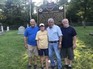
In August 1818, a group of six interrelated Welsh families, led by John Jones (Tirbach) landed in Gallipolis. They journeyed from Cardiganshire, South Wales destined for the Welsh settlement at Paddy’s Run, near Cincinnati. Following their decision to remain here instead, they built cabins in the Symmes Creek Valley on the old Welsh road between Centerville and Oak Hill. The group became the nucleus for later Welsh settlement, as the area became known as “Little Cardiganshire.” Evans Cemetery is on land set aside by John Jones, later owned by grandson Timothy Evans. Approximately 50 souls lie here, several in unmarked graves.
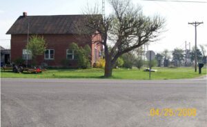
Built in 1886 by direct descendants of slaves, the Black and White schoolhouse provided education for local youth until 1928. Denied admission to white schools in the area, local African-American families first built a log schoolhouse across the road in 1883 in which to educated their children. Three years later, this brick building was constructed. The black families allowed white children to attend and, as a result, the school became known as the Black and White school. It is an early integrated school in Ohio.