Near this location stood the settlement of African American families known as “The Lett Settlement.” The Lett Settlement was a self-sustaining community of mixed race families, including the Caliman, Guy, and Lett families. The families had formed ties through marriage and common background during the mid-1700s in Virginia and Maryland. These early African American pioneer families came to Ohio as “free people of color,” and began acquiring land in Meigs Township, Muskingum County, and surrounding townships in adjacent counties during the 1820s. They were soon joined by the Brown, Clifford, Earley, Simpson, Tate, and Pointer families. The families of the Lett Settlement were land owners and tax payers in Ohio before the Civil War and challenged the State of Ohio for the right to vote and for access to education during the 1840s, 1850s, and 1860s. (Continued on other side)
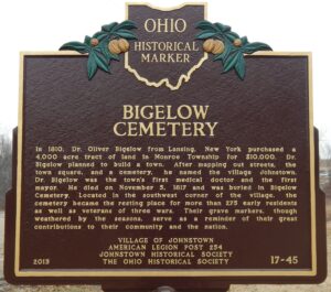
In 1810, Dr. Oliver Bigelow from Lansing, New York purchased a 4,000 acre tract of land in Monroe Township for $10,000. Dr. Bigelow planned to build a town. After mapping out streets, the town square, and a cemetery, he named the village Johnstown. Dr. Bigelow was the town’s first medical doctor and the first mayor. He died on November 5, 1817 and was buried in Bigelow Cemetery. Located in the southwest corner of the village, the cemetery became the resting place for more than 275 early residents as well as veterans of three wars. Their grave markers, though weathered by the seasons, serve as a reminder of their great contributions to their community and the nation.
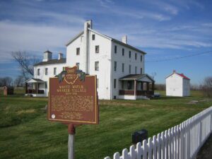
The United Society of Believers (or “Shakers,” as they are commonly known) established White Water, the last of four Ohio Shaker villages, in 1824. White Water flourished throughout the nineteenth and early twentieth centuries. At its peak during the 1850s, 150 Believers living in three semi-autonomous Shaker “families” farmed 1,300 acres of land in Crosby and adjacent Morgan townships. The Shakers were among the most successful religious societies in the United States. Belief in the equality of men and women, separation of the sexes, celibacy, communal ownership of property, and a distinctive style of worship — characterized by rhythmic movements and shaking — helped define the Shaker lifestyle. (Continued on other side)
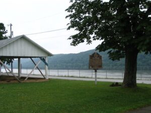
Manchester was founded in 1791 by Nathaniel Massie as a base to survey the land warrants of American Revolutionary War soldiers in the Virginia Military District. This bank of the Ohio River provided a secure site for the last civilian stockade built in Ohio. The natural protection of this fortification included marshland to the west and north and the river on the south. The nearby three islands provided a safe place for retreat in dangerous circumstances and also supplied an area to raise food in its rich bottomlands. The invention of the steam powered paddle wheel boat allowed the river to become the city’s main source of shipping and commerce in the nineteenth century. Manchester was an important port of call for provisions; the export of agricultural products; and the manufacture of goods such as pottery, furniture, and leather goods.
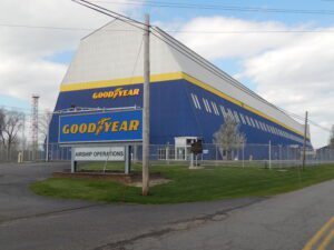
In March 1917, a month before U.S. entry into World War I, The Goodyear Tire & Rubber Company began construction of the hangar on land the firm purchased here in 1916. During World Wars I and II, the hangar was used for building and testing lighter-than-air craft for military uses, including intelligence-gathering and antisubmarine warfare. The first class of Navy airship pilots also trained at Wingfoot Lake. (Continued on other side)
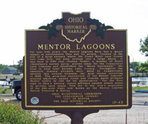
For over 200 years, the Mentor Lagoons have had a major impact on northeastern Ohio and its people. Located on the site of a large estuary where the Grand River once flowed into Lake Erie, the area evolved into a large marsh. It was here in 1797 that Charles Parker, a member of Moses Cleaveland’s survey party, platted lands for the Connecticut Land Company and established the “Marsh Settlement,” the first in what later became Lake County. Throughout the twentieth century, attempts were made to commercially develop this natural treasure, the most recent occurring in 1996. The proposed destruction of the Mentor Lagoons’ pristine lakefront, upland forest and riverine marsh prompted Mentor voters to call for its preservation. For the first time in Ohio’s history, voters affirmed eminent domain action to protect open space. This led to the city’s acquisition of the 450-acre tract, now known as the Mentor Lagoons Nature Preserve & Marina.
Known as the “Halfway House,” the Gooding House and Tavern was built by George B. Gooding halfway between the towns of Worthington and Delaware in 1827. Its location was influenced by construction of the Columbus and Sandusky Turnpike that was chartered by the State of Ohio the year before. Also known as the “Mud Pike,” the turnpike was slow and difficult for travelers and could take nearly a day to travel 10 miles. The Gooding House was the perfect place for stagecoach drivers to change teams of horses and for travelers to rest and have refreshments. George Gooding also prospered as a farmer with over 1,000 acres of land. This stately brick farmstead remained in the Gooding family for 175 years with each succeeding generation adding its imprint on the property. The Gooding House and Tavern was listed on the National Register of Historic Places in 2005 and restored in 2007.
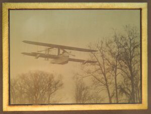
After Wilbur Wright died in 1912, Orville Wright continued to develop and fly airplanes for the Wright Company. Orville flew seaplanes along this part of the Great Miami River from 1913 to 1914. This area had three advantages: deep water formed by a hydraulic dam, freedom from man-made obstructions, and a 90 degree bend in the river that allow him to take off and land either north-south or east-west, depending on prevailing winds. In June and July 1913, Orville made more than 100 flights, frequently with passengers, in the Wright Model C-H “hydroplane.” In 1913 and 1914, Orville and Wright Co. chief engineer Grover Loening developed the Wright Model G “aeroboat.”