Intersection of State Route 554 and Depot Road, Springfield Township
Bidwell
, OH
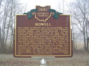
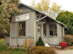
The village of Bidwell, once known as Heatly, was surveyed in 1881 after the arrival of the Columbus, Hocking Valley, and Toledo Railroad. A depot (Porter Station) was soon built on this site for passenger and freight service. By 1900, Heatly was renamed Bidwell, in honor of John Bidwell of California, a Prohibitionist candidate running for the United States presidency. By 1906, a thriving railroad business, coupled with the efforts of J.K. Powell, Charles Heatly, and E.T. Morrison, caused land speculation to boom. The village soon included the Powell Tile Factory, the Morrison General Store, the Heatly housing addition, a post office (1881), a two-room school, a Methodist Church (1892), Mt. Carmel Baptist Church (1903), (Continued)
Agricultural development and cultivation on steep lands led to severe soil erosion in the nation in the 1920s and 1930s. In response, the United States Department of Agriculture established the Soil Conservation Service (SCS) in 1935. The SCS established the North Appalachian Experimental Watershed (NAEW) in the hills of Coshocton County to study and develop methods of conserving soil and water resources. The Federal government and Coshocton County purchased 1,047 acres of land for the program and, in 1936, field research equipment was installed and buildings constructed. The Works Progress Administration (WPA) and Civilian Conservation Corps (CCC) provided labor near the program’s inception, as did the Civilian Public Service Agency during World War II. (Continued on other side)
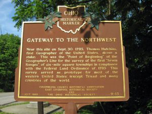
Near this site on Sept. 30, 1785, Thomas Hutchins, first Geographer of the United States, drove a stake: This was the “Point of Beginning” of the Geographer’s Line for the survey of the first “Seven Ranges” of six-mile square townships in compliance with the Federal Land Ordinance of 1785. This survey served as a prototype for most of the western United States (except Texas) and many countries of the world.
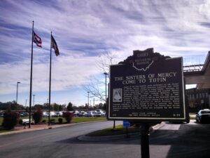
Pastor of St. Mary’s Church, Rev. Thomas F. Conlon met with the newly appointed bishop of the Toledo Diocese, Rt. Rev. Joseph Schrembs, to discuss building a charity hospital for the community. Community leaders and physicians promoted the necessity of a hospital that cared for all people regardless of race, creed, or color. Seven acres of land were purchased from Miss Emma J. Bowe on West Market Street for the construction of a four-story, fireproof brick building. Designed by local businessman George W. Netcher, the new hospital cost approximately $75,000. At the hospital’s dedication on October 26, 1913, Bishop Schrembs praised the people of Tiffin saying, “I appealed to the public-spirited citizens and my appeal did not fall upon deaf ears, as this building testifies.”
Legend has it that Mogadore’s first settler, Ariel Bradley, was a spy for George Washington in October, 1776. As a nine year old boy, Ariel crossed British lines on a supposed errand to the nearest grist mill and returned with troop positions and tent counts. In 1801, Ariel left Connecticut to make his new home in what would be Ohio. In 1807, he built a log cabin on a 146 acre plot of farm land that cost $335. Until 1825 the new community had been named Bradleyville, but Ariel did not want the area named after him. Martin Kent was building a residence and a sailor, John Robinson, climbed to the top of the framework, pulled a flask of whiskey from his pocket. Breaking the flask on the last beam of construction, Robinson shouted “Three cheers for Mogador,” which is a large city in Morocco, thusly christening the area Mogadore.
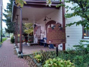
The Society of Separatists of Zoar built the Zoar Town Hall in 1887 when the village was formally incorporated. Established in 1817 by German religious dissidents, Zoar became one of the most successful experiments in communal living during the 19th century. Early hardships encouraged the Zoarites, in 1819, to establish a communal system to ensure economic and social security. The Society disbanded in 1898. The Zoar Historic District was added to the National Register of Historic Places in 1969.
Through the terms of his will, British absentee landowner Samuel Gist (c. 1723-1815) freed his 350 Virginia slaves and provided funds for their relocation, the purchase of land, and the establishment of schools and homes. The executors of Gist’s will acquired over 2,000 acres of land in Ohio, including two large tracts in Scott and Eagle townships in Brown County in 1819. In 1831 and 1835, an agent of the Gist estate purchased 207 acres in Highland County and divided the acreage into thirty-one lots. This Gist settlement in Eagle Township was the first to be purchased and settled. It was recorded at Brown County on August 4, 1819 as 1197 acres of land divided among “150 Negroes who were emancipated by the will of Samuel Gist”. In 2009, descendants of the freed Gist slaves still inhabited part of the original settlement.
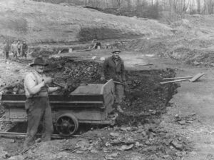
Agriculture dominated the economy of southeastern Ohio’s Morgan County until the 1940s when harvests dwindled, the population declined, and land values dropped. Surface mining the area’s rich underground coal deposits replaced agriculture as the major industry and revitalized the declining local economy. As the nation’s demand for electricity grew over the next half-century, so did the demand for coal as fuel for nearby power generation plants. During mining’s heyday in the 1960s to the late 1980s, American Electric Power’s former Central Ohio Coal Company subsidiary employed nearly 1,000 people. Nearby communities-such as Cumberland, Caldwell and Chandlersville-thrived. As time passed, however, the robust coal industry was hit hard by environmental regulations that reduced the market for the area’s high-sulfur coal. In turn, mine work forces shrank considerably and local businesses closed. (continued on other side)