The first Mt. Tabor Church, a log meetinghouse, was erected on this site in 1816. It stood on land originally selected by Griffith and Martha Evans for a graveyard at the death of their daughter circa 1812. Deeds show the Evans family gave two and one half acres of land “for the purpose of erecting a meetinghouse and establishing a burying site.” Camp meetings, religious gatherings popular in frontier Ohio, were held on the hillside west of the meetinghouse. Simon Kenton was converted at a Mt. Tabor camp meeting in 1819. The log meetinghouse burned in 1824 and was replaced with a brick church on the same spot. In 1881, the present brick church was completed and dedicated.
corner of South Michigan Avenue and East Indiana Street
Edgerton
, OH
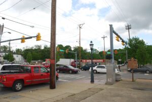
Edgerton was settled beside the St. Joseph River when the Lake Shore & Michigan Southern railroad was completed in 1854. The village was incorporated on December 4, 1865, and named for Alfred P. Edgerton, who donated the land for the park. He was an agent for Hicks & Company, a land speculation business. The firm of Von Behren & Shaffer built the town hall and opera house in 1884 for $7,998. The building and park became a hub of local activity. The park’s bandstand showcased the Edgerton Village Band and citizens gathered for picnics and festivities. (Continued on other side)
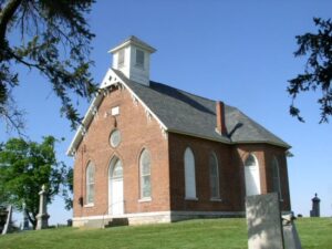
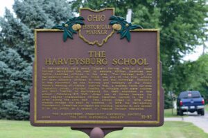
The Quaker village of Harveysburg was founded in 1829 on land originally a part of Colonel Abraham Buford’s Revolutionary War Land Grant. Levi Lukens, a Virginia Quaker, purchased the 1000 – acre survey in 1812 and sold a portion to Rhoden Ham in 1815. Ham then sold a portion of his holdings to William Harvey, a Quaker originally from North Carolina, who developed 47 lots for a village which thrived from its beginnings. Early businesses included grist mills, a tin shop, hardware store, blacksmith shop, a large pork packing plant, a bank, and a dry goods store owned by William Harvey. Its first post office opened in 1839. Harveysburg was incorporated in 1844. The village received its name from a merchant in Cincinnati who told William Harvey that he should add burg to his name and call the place Harveysburg.
First a farming community, later a railroad crossroads in southern Hancock County, Arlington was one of the county’s earliest settlements. Gen. William Hull opened a trail into the area during the War of 1812 as he crossed Buck Run at Eagle Creek. He led his army to the Blanchard River to establish Ft. Findlay. Robert Hurd owned extensive tracts of land in the area, and his sons were the first recorded settlers, building a log cabin near this site in 1834. The rich farmland and abundant water soon attracted other settlers to the vicinity of “Hurdtown.” The name was changed to “Arlington” when the village was formally surveyed in November, 1844.
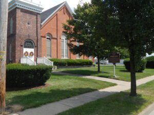
The Rev. Jacob Ward founded the Brunswick Methodist Episcopal Church in April 1817 with 13 members: Rhoda Stow, John and Lucy Stearns, John and Hannah Hulet, Samuel and Sarah Tillotson, Thomas and Phoebe Stearns, Solomon and Polly Harvey, Lydia Crittenden, and Olivia Ashley. In 1830, John and Lucy Stearns donated land for a cemetery, which included space for a church. A new church was completed in 1872. Bricks used for the building were fired locally and the first windows were glazed with clear glass and protected by shutters. In 1916, the church was extensively remodeled and redecorated. Stained glass replaced the clear glass, the church bell was relocated to the newly-added tower, and the main entrance was moved from the center of the building to the vestibule in the tower. (Continued on other side)
SW corner of Reading Road/US 42 and W Columbia Avenue
Reading
, OH
In 1794 Abraham Voorhees, a Revolutionary War veteran, brought his family from New Jersey to the Northwest Territory to settle on 640 acres of land, part of the Miami Purchase, for which he paid John Cleves Symmes “533 dollars 30/90ths” in United States Treasury Certificates. By 1798 the town was platted and lots were being sold. Official registration of the plat was completed in 1804, the town’s name being changed to Reading at the suggestion of Henry Redinbo, who had moved his family to the area from Reading, Pennsylvania, in 1795.
Anson Williams visited Ohio in 1834 before he moved to Orange Township. A former resident of New York State, Williams purchased this site and the surrounding 1,000 acres of U.S. Military District lands and hoped to find opportunity for himself and his family. He bought the land for $6.00 an acre from James D. Wolf, who owned the 4,000-acre section three of Orange Township. The Village of Williamsville was laid out with 80 lots in 1836 on both sides of the Columbus and Sandusky Turnpike. Williams built his home and a hotel with a store and tavern. A hotel and tavern, owned by George Gooding and where the stage changed horses, had already been established north of Williamsville. Competition may have led to Williamsville’s decline. A church was built in 1845 and remained until 1900. Anson died in 1847, and his wife Hannah passed away in 1851. Both are buried in nearby Williamsville Cemetery.
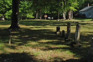
Deer Creek Quaker Cemetery was established on land donated by Isaac Coates, who brought his family from Chester County, Pennsylvania to settle in Lexington Township in 1820. The name Deer Creek comes from the nearby stream and it signifies the numerous deer that have abounded in the vicinity. The cemetery sits across from the former Deer Creek Quaker Meeting House. Isaac Coates is among the pioneers laid to rest here.