

, OH
One of America’s best-known sport shooters and entertainers of the late 1800s, Annie Oakley was born Phoebe Ann Mosey (or Mozee) north of Versailles in Darke County in 1860. She achieved local fame for her shooting ability as a hunter while still in her teens. By 1885 Oakley was a star performer in Buffalo Bill’s Wild West. With husband and manager Frank Butler, she refined a shooting act and image that appealed to late 19th century notions of a romanticized but vanishing West. Throughout her 30-year performing career, Oakley provided honest entertainment in a deception-prone industry while demonstrating widening opportunities for women. She retained her Ohio ties throughout her life and is interred at Brock Cemetery, eleven miles north of Greenville.
, OH
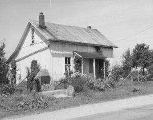
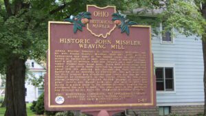
Johann Mischler (changed to John Mishler), 1852-1930, and his wife Rosina Beyeler Mischler, 1852-1927, were born in Switzerland and came to the United States in 1882. They moved to Smithville in 1887 where John, a weaver by trade, built a mill to produce rugs and carpets on a hand operated timber framed barn beam loom. Three belt driven looms were added in the early 1900s powered by steam and later diesel. About 1915, the weaving mill became the first business in Smithville to be operated by electricity. The mill wove cloth for fruit presses and dishcloths and towels and was the only producer of cheesecloth in the United States for the Swiss cheese industry. It produced 40,000 pounds of cloth per year. John’s son Daniel took over the mill in 1930 and moved it a block away to its present location. Charles Norris purchased the mill in 1983. Ten years later, it was purchased and restored by the Smithville Community Historical Society.
, OH
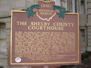
In 1819, the State of Ohio formally recognized Shelby County, named for Isaac Shelby, veteran of the American Revolution and former governor of Kentucky. The first county seat was located in Hardin, but was moved to Sidney in 1820 to centralize county government. The corner stone of the present courthouse was laid on July 4, 1881. George Maetzel from Columbus served as architect and superintendent of construction. Modeled after the county courthouse in Licking County, the project was completed in 1883 at a cost of $200,000. Materials, such as limestone, sandstone, and marble arrived by canal boat. The French Second Empire style building has four symmetrical sides facing the four points of the compass, each side with pillared porticoes approached by broad stone steps. A figure of Lady Justice holding the scales of equal justice surmounts each facade. The roof is classical mansard, and the center170-foot tower is of galvanized iron, encompassing four clocks.
, OH
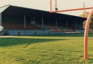
Opened in 1926, Tanks Memorial Stadium became the home of the Ironton Tanks semi-professional football team. The Tanks were formed in 1919 and through the years played other semi-professional teams as well as teams from the American Professional Football Association that became the National Football League in 1930. In twelve seasons the Tanks had a record of 85 wins, 19 losses, and 14 ties, including wins against the Chicago Bears and New York Giants. The Tanks disbanded in 1931, but five players moved on to the Portsmouth Spartans, which became the Detroit Lions, and other NFL teams picked up four other players. Tanks Memorial Stadium is one of the few remaining roofed high school football stadiums in the country.
, OH
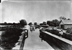
Digging of the Ohio-Erie Canal began in 1825, and the first canal boat navigated the Deep Cut at Licking Summit in 1831. The surrounding swamps were drained to create the Licking Reservoir, today known as Buckeye Lake, in order to supply adequate water for the canal going north to Coshocton and south to Circleville. After the canal route was established, the state engineers discovered that there was a ridge of hills located south of the proposed reservoir through which they would have to cut the canal. Since it was impossible to raise the level of the reservoir, the ridge had to be cut down to the level of the reservoir. This “Deep Cut” marks the deepest part of the canal at 32 feet and runs south from Millersport for nearly two miles. Unskilled laborers, primarily Irish immigrants, tirelessly dug the canal using picks, shovels, wheelbarrows, and oxen-cart.
, OH
Conceived by leaders of the automobile industry to encourage the building of “good roads,” the Lincoln Highway was established in 1913 as the first transcontinental automobile route in the United States. It traversed twelve states and 3,389 miles from New York to San Francisco. The first route across Ohio connected Van Wert, Delphos, Lima, Ada, Upper Sandusky, Bucyrus, Galion, Mansfield, Ashland, Wooster, Massillon, Canton, Minerva, Lisbon, and East Liverpool. By the 1930s much of the original route had become part of the Federal Highway System and U.S. Route 30–many miles of which have, in turn, been bypassed by modern four-lane highways.
, OH
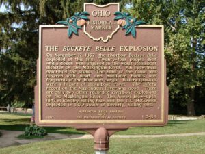
On November 12, 1852, the riverboat “Buckeye Belle” exploded at this site. Twenty-four people died and a dozen were injured in the worst steamboat disaster on the Muskingum River. An eyewitness described the scene: “The bank of the canal was covered with dead and mutilated bodies and fragments of the boat and cargo.” Boiler explosions were a hazard of steamboat travel. The safety record on the Muskingum River was good. There are only two other recorded riverboat explosions on the Muskingum River. The “Newark” blew-up in 1847 at Rokeby, killing four, and the “L.C. McCormick” exploded in 1879 south of Beverly, killing one.
, OH
Ripley was incorporated as the village of Staunton in 1812. Its name was changed in 1816 to honor General Eleazer Wheelock Ripley, a hero of the War of 1812. In the years before railroads, Ripley was a principal Ohio River shipping center. Also important were its extensive boat-building, tobacco, pork, and timber industries. Ripley too was the home of saw and planing mills, iron foundries, and a piano factory. Such varied commerce enabled Ripley to remain vibrant throughout the nineteenth century. Although noted as a port, Ripley is best remembered as an abolitionist stronghold. Many of its citizens, including Rev. John Rankin and John P. Parker, served as conductors on the famed “Underground Railroad.” The notoriety of Ripley’s anti-slavery network perhaps eclipsed that of nearby Cincinnati, earning the town a reputation as the “Black Hole of Abolitionism.” (Continued on side two)