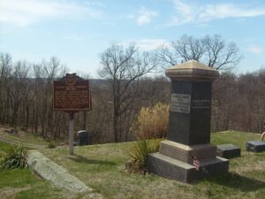
Fort Amanda State Memorial, OH 198, 1/4 mile S of Ft. Amanda Road, Lima
Lima
, OH
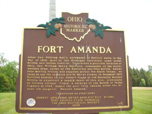
After Gen. William Hull’s surrender at Detroit early in the War of 1812, most of the Michigan Territory came under British and Indian control. To prevent a possible invasion of Ohio, Gen. William Henry Harrison, commander of the Northwestern Army, called up the Kentucky and Ohio militia. Rather than moving troops and supplies across the Black Swamp, he chose to use the Auglaize and St. Marys rivers. In November 1812 Harrison ordered Lt. Col. Robert Pogue of the Kentucky Mounted Militia to construct a supply depot at this site, previously an Ottawa village. Pogue, a veteran of the Battle of Fallen Timbers in 1794, named the post Fort Amanda after his 12-year-old daughter, Hannah Amanda. (continued on other side)
Constitution Park-Just N of Intersection of OH 725 and US 42
Spring Valley
, OH
In 1779 John Bowman’s forces followed the east bank to Glady Run, then north to the Indian village of Old Chillicothe. In 1780 and 1782 militia commanded by George Rogers Clark, and guided by Simon Kenton and Daniel Boone, crossed the river and camped two miles north of Caesar’s Creek, then marched on the villages near Springfield, Piqua, and Bellefontaine.
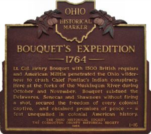
Lt. Col. Henry Bouquet with 1500 British regulars and American militia penetrated the Ohio wilderness to crush Chief Pontiac’s Indian conspiracy. Here at the forks of the Muskingum River during October and November, Bouquet subdued the Delawares, Senecas, and Shawnee without firing a shot, secured the freedom of every colonial captive, and obtained promises of peace–a feat unequaled in colonial American history.
Regular and militia troops under General James Wilkinson built this supply post and defensive fortification in March 1792 in preparation for Gen. “Mad Anthony” Wayne’s campaign against the Indians of the Northwest Territory, following disastrous expeditions in 1790 and 1791. Built near a “fine spring gushing out of the bank, ” the 120-foot square palisade fort had a four-sided bastion at each corner. Future U.S. president William Henry Harrison served in the detachment that built the fort. On November 6, 1792, Miami Chief Little Turtle and approximately 200 warriors attacked a force of Kentucky militia under Maj. John Adair camped outside the fort. Six Kentuckians and an unknown number of Indians died in the skirmish. The fallen soldiers were buried fifty paces west of the fort, beneath the “Whispering Oak.”
In Greenwood Cemetery, at the end of Greenwood Road
Racine
, OH
Born at Oak Grove, prospected in the California goldfields in 1849. During the Civil War he raised a militia company at Racine, and was later promoted Captain of Co. K, 18th O.V.I. After the war, he served on the Racine Village council, Sheriff of Meigs County, and was a member of the Ohio General Assembly. He was Secretary-Treasurer of the Ohio Commission for the Chichamauga Battleground National Park, and served 14 years as Postmaster of the U.S. House of Representatives.
The founder of Ravenna Township in 1799, Benjamin Tappan Jr. led a distinguished life of public service. An aggressive force in local politics, he served in the Ohio Senate from 1803 to 1805, as judge of the fifth circuit court of common pleas from 1816 to 1823, and as federal district judge from 1826 to 1833. Tappan served as aide-de-camp to Major General Elijah Wadsworth following the surrender of Detroit in the War of 1812, provisioning and arming local militia units defending the northwestern frontier against a possible British invasion. (continued on other side)
Plunging herds of buffalo seeking salt licks and grazing lands wore trails through the Ohio Country when it was an Indian no-man’s land. Later, Indians found the same trails suitable for their needs. The tawny paths were highways as well as highest ways. Indians found ridges and summits superior to valleys for trails because they were drier, windswept of snow, never clogged by flood debris and safer.
The Northwest Ordinance of 1787 defined the boundary of the northern and southern tier of states to be carved out of the Northwest Territory, as a line drawn east from the southernmost tip of Lake Michigan until it intersects Lake Erie. Controversy over the exact location of that line led to the 1834-1837 boundary dispute between the State of Ohio and Michigan Territory. Passions ran high as everyone on both sides of the boundary knew that a great port city (Toledo) would emerge in the disputed territory. President Andrew Jackson settled the dispute in 1836 when he signed an act that recognized the current border between Ohio and Michigan, giving Michigan 9,000 square miles of Upper Peninsula land and awarding the disputed strip of approximately 470 square miles to Ohio. Michigan then joined the nation as a state the following year.