In 1798, Judge Samuel Hinckley of Northampton, Massachusetts, drew the 72nd draft in the land lottery held by the Connecticut Land Company and received 15,305 acres in Township 4, Range 1, for which he paid $12,903.23, less than one dollar per acre. The area had been inhabited for many years by trappers, missionaries, and Native Americans. One of the earliest settlers was James McMullen, who acquired the first 160-acre parcel from Hinckley in 1801. Brookfield Township became the crown jewel of Hinckley’s holdings. Hinckley named Brookfield after a city in England and set aside land for the village green and the cemetery stating that they were for public use forever. During the mid-1820s the Overland Stage Line had a run through Brookfield, linking it to Salem, Warren, and Youngstown in Ohio and Erie, Pennsylvania and Dunkirk, New York. (Continued on other side)
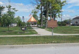
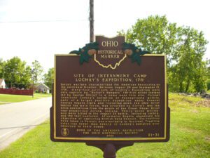
Border warfare characterized the American Revolution on the northwest frontier. Between August 26 and September 15, 1781, sixty-four survivors of Lochry’s Expedition were held captive by “Butler’s Rangers” (British-allied Indians led by George Girty) in a camp near this site. Colonel Archibald Lochry’s battalion of Pennsylvania militia, part of a larger punitive expedition under General George Rogers Clark and traveling down the Ohio River behind the main force, was attacked by Girty’s men ten miles downstream from the mouth of the Great Miami River near present-day Aurora, Indiana. Thirty-seven militiamen were killed in the August 24 battle, including Lochry, and the rest captured. Afterwards Rogers abandoned his objective of capturing British-held Detroit. The captives were taken to Detroit and eventually to Montreal. Tradition holds that fewer than twenty of Lochry’s battalion ever returned to their homes.
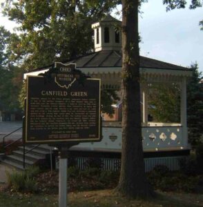
Canfield, named for the area’s primary landowner Judson Canfield, is one of the earliest examples of a New England town plan in both Ohio and the Western Reserve. It dates to April 20, 1798, when surveyor Nathaniel Church arrived from Connecticut to layout the town. Church and his team erected a log cabin and laid out roads and lots using a New England Green Plan that envisioned a communal ground at the center that would later be surrounded by various civil buildings. During the War of 1812, the Canfield Green was used as a drill ground for the Northern Ohio and Western Reserve militia, led by General Elijah Wadsworth. On August 23, 1812, General Wadsworth and the Canfield Dragoons left the Canfield Green heading for Cleveland to defend the United States and the Western Reserve from attacks by the British and their Native American allies. (Continued on other side)
Lucas County was named for Governor Robert Lucas who championed Ohio’s cause in the “Toledo War,” a boundary dispute arising when both Ohio and the Michigan Territory claimed this area. The Ohio legislature created Lucas County on June 20, 1835. The first court session convened in a Toledo schoolhouse during the pre-dawn hours of September 7 to avoid the Michigan militia.
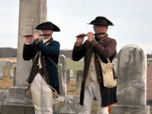
Field Musician Richard W. Thompson. Tunes played on fife and drum regulated a soldier’s life in camp and his actions on the battlefield. Heard over the roar of battle and through the haze of smoke, fifes and drums – field music – communicated orders to massed troops quickly. Richard Willoughby Thompson (c. 1742-1837), buried in Fancher Cemetery, was a field musician during the American Revolution and the War of 1812. According to his grandson Henry’s recollections from the 1920s, Thompson was born in Dublin, Ireland, and enlisted in the British army, where his service culminated in his capture while picking blackberries. He switched allegiances, joined the colonials, and was sent to Virginia. Thompson was appointed the Fife Major of the 5th Virginia Regiment and remained a Fife Major as Virginia units organized during the war. (Continued on other side)
Underground Railroad crossings, agents, and conductors were common along the Ohio River between Washington County, Ohio and Wood County, Virginia. At Constitution, six miles upriver from Belpre, Judge Ephraim Cutler listened for hoot owl calls that signaled when a boatload of runaway slaves was crossing from Virginia to the Ohio shore. “Aunt Jenny,” a slave woman in Virginia, used a horn signal to alert abolitionist John Stone in Belpre when fugitive slaves were crossing. At Little Hocking, eight miles downriver from Belpre, slaves crossing from Virginia looked for a lantern signal to guide them to the Horace Curtis Station on the Ohio River shore. Runaway slaves were also assisted by Thomas Vickers at Twin Bridges, James Lawton at Barlow, and others as they traveled northward by various routes through Morgan County to Putnam in Muskingum County where the Underground Railroad merged with the Muskingum River Corridor.
Born in Kentucky in 1793, his family moved to the Ohio country in 1797. Taught by his mother and in a log-cabin school near Dayton, he began teaching here by 1809. Purchasing land here in 1811, he served at Fort Greenville in the War of 1812. He married Priscilla Knight in 1815 and fathered eleven children. He held offices of assessor, appraiser, constable, trustee, justice of the peace, and attained the rank of Brigadier General in the Ohio Militia. He died in 1883 and is buried here in Lostcreek Cemetery.
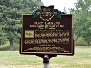
During the American Revolution, Fort Laurens became the only Continental military fort in what would later be Ohio. Continental army troops and militia, led by General Lachlan McIntosh, built the fort between November-December 1778. Named for the president of the Continental Congress, Henry Laurens, the army intended to use the fort to launch an offensive against British-held Fort Detroit, observe enemy movements, and stage attacks on British-allied Indian villages. To fulfill terms in the “Treaty with the Delaware” (1778), McIntosh chose a site about two miles south of the “Great Crossing” on the Tuscarawas River in friendly Lenape (Delaware) territory. (Continued on other side)