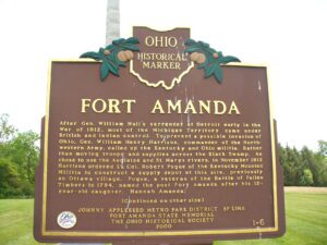
Fort Amanda State Memorial, OH 198, 1/4 mile S of Ft. Amanda Road, Lima
Lima
, OH
After Gen. William Hull’s surrender at Detroit early in the War of 1812, most of the Michigan Territory came under British and Indian control. To prevent a possible invasion of Ohio, Gen. William Henry Harrison, commander of the Northwestern Army, called up the Kentucky and Ohio militia. Rather than moving troops and supplies across the Black Swamp, he chose to use the Auglaize and St. Marys rivers. In November 1812 Harrison ordered Lt. Col. Robert Pogue of the Kentucky Mounted Militia to construct a supply depot at this site, previously an Ottawa village. Pogue, a veteran of the Battle of Fallen Timbers in 1794, named the post Fort Amanda after his 12-year-old daughter, Hannah Amanda. (continued on other side)
You are standing on the famous portage, carrying-place between the Cuyahoga and Tuscarawas rivers. The two streams and the portage across the watershed formed an early route between Lake Erie and the Ohio River. First the Indians, then French and English traders and trappers, and finally American settlers and travelers carried their canoes and packs across this narrow strip of land in passing, by way of the rivers, between northern and southern Ohio. The portage was a part of the defined boundaries in the treaties with the Indians made at Fort McIntosh (1785), Fort Harmar (1789), and Green Ville (1795). Use of the portage was discontinued in 1827 when the Ohio and Erie Canal was built along the old trail. Today, modern Akron streets–Portage Path and Manchester Road–follow the approximate route of the original portage.
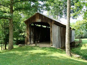
This covered bridge, spanning Salt Creek in Perry Township, Muskingum County was erected in the 1870s. It is a splendid example of an Ohio covered bridge built with Warren type trusses. It is being preserved as an important illustration of the sound, fine craftsmanship of the early bridge builders of Ohio. This plaque has been erected to give these men the honor they greatly deserve.
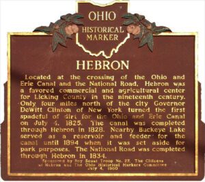
Located at the crossing of the Ohio and Erie Canal and the National Road, Hebron was a favored commercial and agricultural center for Licking County in the nineteenth century. Only four miles north of the city Governor DeWitt Clinton of New York turned the first spadeful of dirt for the Ohio and Erie canal on July 4, 1825. The canal was completed through Hebron in 1828. Nearby Buckeye Lake served as a reservoir and feeder for the canal until 1894 when it was set aside for park purposes. The National Road was completed through Hebron in 1834.
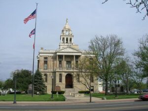
Opened on May 1, 1885, this is the third Fayette County Court House building. Ohio artist Archibald Willard, who is best known for the patriotic painting, “The Spirit of ’76,” was commissioned by the firm Cooks Brothers to do painting and fresco work for the interior walls of the courthouse. Willard did not sign his work and the artist’s identity remained a mystery for nearly 75 years until confirmation was made in August 1956. The artist’s name was cleverly disguised in the delivery address of the letter in “The Spirit of the U.S. Mail” mural. The other primary murals, “Spirit of Electricity” and “Spirit of the Telegraph,” adorn the third floor corridor.
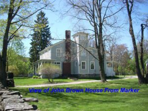
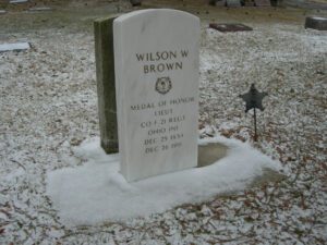
Medal of Honor winner, who is buried here. He joined the famous Andrews Raiders to wreck Confederate supply lines. The raiders captured a locomotive, “The General,” at Big Shanty, Georgia, on April 12, 1862. Brown served as the engineer and was captured after the “General” ran out of fuel. He escaped on October 16 and made his way back to Union lines after enduring great hardships.
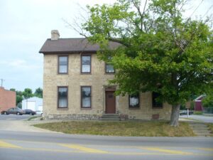
The Smith Tannery is the oldest original structure remaining in Greenfield. Built in 1821 by Revolutionary War veteran William Smith and his son Samuel, the tannery became a noted station on the fabled “Underground Railroad.” The structure, which also served as the family residence, was the birthplace of Dr. Samuel M. Smith, Surgeon General of Ohio during the Civil War, and Dr. William R. Smith, who personally notified Abraham Lincoln of his nomination to the presidency in 1864. The Smiths were active members of the Abolition Society of Paint Valley, which was established in 1833 in Greenfield and reorganized in 1836 as the Greenfield Anti-Slavery Society. In 1844, the Society assisted the efforts of Frederick Douglass, one of the nation’s leading abolitionists. The Society provided an important junction on the Underground Railroad, assisting many fugitive slaves to gain freedom, including, it is said, Eliza Jane Harris of Uncle Tom’s Cabin fame. The Smith Tannery was named to the National Register of Historic Places in 1978.
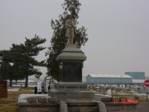
In memory of William Bensinger and John R. Porter who are buried here. They joined the famous Andrews Raid to wreck the Confederate supply lines. The Raiders captured a locomotive, “The General,” at Big Shanty, Georgia on April 12, 1862. Private Porter missed the great locomotive chase which followed. Pvt. Bensinger was aboard when “The General” ran out of fuel and was captured. Both men received the Congressional Medal of Honor.