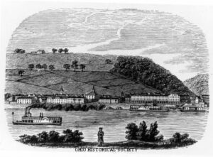
Ripley was incorporated as the village of Staunton in 1812. Its name was changed in 1816 to honor General Eleazer Wheelock Ripley, a hero of the War of 1812. In the years before railroads, Ripley was a principal Ohio River shipping center. Also important were its extensive boat-building, tobacco, pork, and timber industries. Ripley too was the home of saw and planing mills, iron foundries, and a piano factory. Such varied commerce enabled Ripley to remain vibrant throughout the nineteenth century. Although noted as a port, Ripley is best remembered as an abolitionist stronghold. Many of its citizens, including Rev. John Rankin and John P. Parker, served as conductors on the famed “Underground Railroad.” The notoriety of Ripley’s anti-slavery network perhaps eclipsed that of nearby Cincinnati, earning the town a reputation as the “Black Hole of Abolitionism.” (Continued on side two)
SE of intersection of Paige Street & N Lynn Street
Bryan
, OH
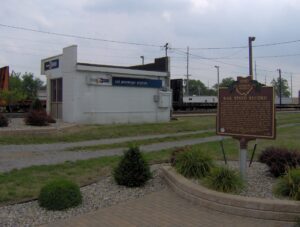
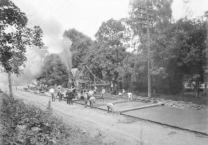
In 1966 the New York Central Railroad Company (A.E. Perlman, President) proposed a test of existing rail passenger equipment to determine the feasibility of operating high-speed passenger service between cities up to 300 miles apart. The site chosen for the test was near Bryan, Ohio on the longest multiple track straight railroad line in the world. This sixty-seven mile straight trackage from Toledo, Ohio to Butler, Indiana was originally constructed by the Northern Indiana Railroad Company of Ohio incorporated March 3, 1851. On July 23, 1966 the New York Central Technical Research Department ran their Budd RDC-3 passenger car number M-497 fully instrumented for stress analysis, and propelled by two roof-mounted jet aircraft engines. The speed of 183.85 miles per hour was attained, the highest recorded on a railroad in North America at that time and to this day.
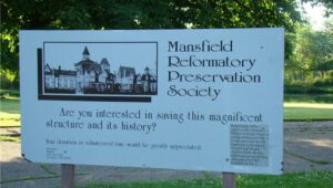
Designed by architect Levi T. Scofield, the Ohio State Reformatory opened its doors in 1896 as a facility to rehabilitate young male offenders through hard work and education. A self-sufficient institution with its own power plant and working farm, the reformatory produced goods in its workshops for other state institutions and provided opportunities for inmates to learn trades. As social attitudes towards crime hardened in the mid-twentieth century, it became a maximum-security facility. The six-tier East Cell Block is the largest known structure of its kind. Considered substandard by the 1970s, The Ohio State Reformatory closed in 1990. It has served since as a setting for several major motion pictures. This Mansfield landmark was added to the National Register of Historic Places in 1983.
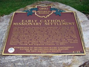
The Society of the Precious Blood, established in Italy in 1815, began its American ministry here in Peru in January 1844, led by Swiss missionary Father Francis de Sales Brunner. Continuing the work begun by the Redemptorists at St. Alphonse in 1833, the Missionaries of the Precious Blood, or “Sanguinists,” brought spiritual support and education to German immigrants in northern Ohio. In July 1844 the Sisters of the Precious Blood, established in Switzerland in 1834, began their ministry of prayer and education here. The priests, brothers, and sisters attended to the needs of parishes across northern Ohio, and between 1844 and 1856 established nine major foundations throughout Seneca, Mercer, Putnam and Auglaize Counties in Ohio.
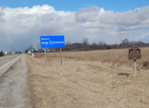
After the War of 1812, the United States Congress proposed two million acres of military bounty land for the Michigan Territory. To survey the land, the meridian had to first be established. U.S. Surveyor General Edward Tiffin created the meridian based on the western line of the Treaty of Detroit (1807). He contracted with Deputy Surveyor Benjamin Hough in April 1815 to begin the survey for $3 per mile. Taking a reading from Polaris (the North Star), Hough, Alexander Holmes, and 11 crew members surveyed the line due north from Fort Defiance. The difficult terrain they encountered temporarily halted all surveys in the territory and ultimately led to the bounty land being transferred to the Illinois and Missouri Territories.
Colonel Ebenezer Zane, one of the founders of Wheeling, laid out the village that became Bridgeport in 1806 on the site of Fort Kirkwood (1789). Originally named Canton, it acquired its present name after the bridge to Wheeling Island was built. The arrival of the National Road in 1818 made the growing town a major portal into the state of Ohio for westbound emigrants, adding to its importance as a port for Ohio River traffic. With the advent of railroads and, later, transcontinental highways, Bridgeport continues to serve as Ohio’s “Gateway to the West.”
A migration of Indians throughout Ohio began due to unstable conditions created by the American Revolution. The massacre of Christian Indians at the Moravian mission of Gnadenhutten in 1782 and Colonel William Crawford’s expedition against Wyandot and Delaware towns along the Sandusky fueled insecurities. Delaware, including a small group of Mingo Indians, abandoned the village of Helltown, five miles southwest of this site, and settled Greentown as early as 1783. Greentown, situated on an elevation on the Black Fork beyond the clearing behind this site, was presumably named for British loyalist, Thomas Green. John Chapman (Johnny Appleseed) had an amicable relationship with the Delaware, owned land throughout the Black Fork Valley, and was known to visit Greentown on his travels throughout Ohio. Other visitors to the village included the Shawnee Prophet; Munsee Delaware leader, Captain Pipe; and local preacher, James Copus.
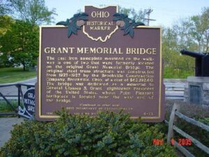
The cast iron nameplate mounted on the walkway is one of two that were formerly located on the original Grant Memorial Bridge. The original steel truss structure was constructed from 1925-1927 by the Brookville Construction Company, Brookville, Ohio, at a cost of $62,192.60. The Bridge was dedicated as a memorial to General Ulysses S. Grant, eighteenth President of the United States, whose Point Pleasant birthplace is located near the west end of the bridge.