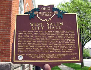
The West Salem City Hall reflects a late-1800s municipal trend to house many civic functions under one roof. The fire station, jail, and council chambers occupied the ground level, while the second floor hosted a public auditorium, or “opera house.” Designed by native son William K. Shilling, later an internationally prominent architect, the Romanesque-style building was completed in 1899 at a cost of $9,077 and soon became the center of civic life in West Salem. Band concerts, vaudeville shows, town meetings, and graduation ceremonies were conducted in the opera house during its heyday before World War II. During the Cold War it was designated as a Civil Defense emergency field hospital. It remains a focal point of the West Salem community.
War of 1812. Victoriously defended by Major George Croghan. Battle of Fort Stephenson. August 2, 1813. Built on this spot 1812-1813 and named for Col. Mills Stephenson, one of its builders.
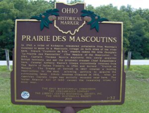
In 1742, a tribe of Kickapoo requested permission from Montreal’s Governor to move to a Mascoutin village on both sides of the river here. French “Coureurs de Bois” traders named the wide floodplain “La Prairie des Mascoutins” (The Meadow of the Mascoutin). In 1764, Captain Thomas Morris explored this newly acquired British territory, and met the prophetic dreamer Chief Katapelleecy here. General Anthony Wayne’s troops victoriously returned from The Battle of Fallen Timbers in 1794 and burned “Prairie de Masque.” The Treaty of Detroit in 1807 created a hunting reservation to the east, allowing settlers to acquire the surrounding lands. Ethnic tensions climaxed in 1812, when an American Captain Logan was mortally wounded near here. The Indian Removal Act of 1830 caused the remaining tribes to move west.
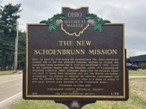
Here, on April 10, 1779 during the Revolutionary War, David Zeisberger founded one of the five Delaware Christian missions to occupy the Tuscarawas Valley between May 3, 1772 and September 8, 1781. Living at the Lichtenau mission near the Delaware capital of Goschachgunk (presently Coshocton, Ohio), Zeisberger feared that the Delaware nation was about to break their neutrality and join the British led Indians. Accordingly, he decided to disperse his Christian congregation and move his converts thirty-five miles up river to a place of safety in this large alluvial plain adjacent to the Tuscarawas River.
Born at Wallingford, Connecticut. Served during the Revolutionary War. Proprietor, Agent, and Surveyor of the Connecticut Land Company. Appointed Judge of Trumbull County by Territorial Governor Arthur St. Clair, 1800. State Senator, Trumbull County, 1815-1816. Poland Justice of the Peace, twenty years. Moderator of St. James Episcopal Church, Boardman, 1809. First Worshipful Master of Erie Lodge No. 47, Warren, 1803, oldest lodge in the Connecticut Western Reserve and one of six lodges to form the Grand Lodge of Free and Accepted Masons of Ohio, 1809.
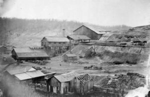
To furnish the needs of the early settlers, then to furnish ordnance for a nation at war, and finally to furnish merchant iron to the steel mills, 100 iron producing blast furnaces were built within these 1,800 square miles of the lower coal measures to become known as the Hanging Rock Region. Lawrence County, centrally located within the Region, had 23 blast furnaces constructed between 1826 and 1909.
Its location and the tides of war established Gallipolis, then a town of some 3,000, as a point of strategic military importance to the Union upon the outbreak of the conflict in 1861. It was destined during the next four years to play a role without counterpart in Ohio. Here through this troop concentration area passed thousands of soldiers to the great campaigns. Here the traditional peacetime activity of the town, long a depot of supplies for the Kanawha Valley, was turned to military purposes for maintaining armies in the field. Here riverside warehouses held vast military stores to be transported by steamboat. Here newly-mustered troops set up Camp Carrington in a wheat field on the upper side of town. Here the women of Gallipolis helped minister to thousands of wounded and sick in an army hospital
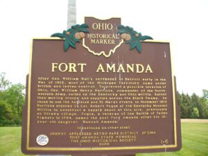
Fort Amanda State Memorial, OH 198, 1/4 mile S of Ft. Amanda Road, Lima
Lima
, OH
After Gen. William Hull’s surrender at Detroit early in the War of 1812, most of the Michigan Territory came under British and Indian control. To prevent a possible invasion of Ohio, Gen. William Henry Harrison, commander of the Northwestern Army, called up the Kentucky and Ohio militia. Rather than moving troops and supplies across the Black Swamp, he chose to use the Auglaize and St. Marys rivers. In November 1812 Harrison ordered Lt. Col. Robert Pogue of the Kentucky Mounted Militia to construct a supply depot at this site, previously an Ottawa village. Pogue, a veteran of the Battle of Fallen Timbers in 1794, named the post Fort Amanda after his 12-year-old daughter, Hannah Amanda. (continued on other side)