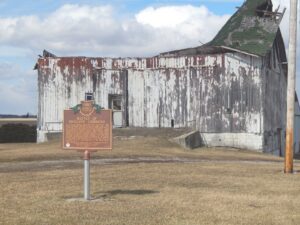
The Northwest Ordinance of 1787 defined the boundary of the northern and southern tier of states to be carved out of the Northwest Territory, as a line drawn east from the southernmost tip of Lake Michigan until it intersects Lake Erie. Controversy over the exact location of that line led to the 1834-1837 boundary dispute between the State of Ohio and Michigan Territory. Passions ran high as everyone on both sides of the boundary knew that a great port city (Toledo) would emerge in the disputed territory. President Andrew Jackson settled the dispute in 1836 when he signed an act that recognized the current border between Ohio and Michigan, giving Michigan 9,000 square miles of Upper Peninsula land and awarding the disputed strip of approximately 470 square miles to Ohio. Michigan then joined the nation as a state the following year.
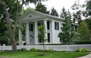
Theodore Dreiser wrote in 1900 his famous novel, Sister Carrie, in this house. It was built in 1835 and altered to Greek Revival Style in 1844. Dreiser acquired it in 1899. The house possesses most of the features typical of the American “classic temple” including four Doric columns rising the full length of the structure. In 1967 the house is owned by the William M. Hankins family.
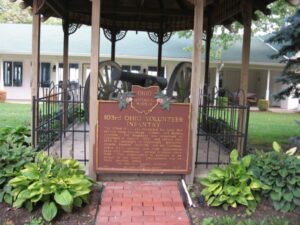
The 103rd O.V.I. was recruited for Civil War service from Cuyahoga, Lorain, and Medina counties. The Regiment was organized at Cleveland in August, 1862, and served until 1865 in campaigns at Cincinnati, Knoxville, Atlanta, Franklin, Nashville, and the Carolinas.103rd O.V.I. veterans and their descendants have held continuous, annual reunions since 1867. The organization is believed to be unique in the nation. Descendants live on these grounds today.
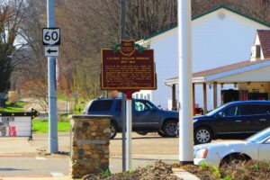
Colonel William Simmons (1757-1823) served in the Continental Army under the command of General Washington. Appointed as Accountant of the War Department by Washington and served under Presidents Adams, Jefferson and Madison. For his services in the Continental Army, received a land grant in the northeast section of Jefferson Township in Coshocton County.
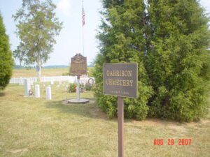
Descendants of Lemuel Garrison Sr., a Revolutionary War soldier, were among the first Europeans to own and settle land at Garrison Corner (intersection of State Route 123 and Shawnee Trace) . Garrison Cemetery burials took place from ca. 1837 to 1936. The cemetery has 327 lots. Eighty-six burials are documented including veterans John J. Garrsion, Benjamin Garritson, James Knicely, Nicodemus Rude, and William Rude. (continued on other side)
The inn was built 1800-01 by Peter Wickerham, a Revolutionary War veteran. It was used as an overnight stagecoach stop and tavern on Zane’s Trace until ca. 1850. Runaway slaves were hidden here when the “Underground Railroad” was in operation. Confederate soldiers, commanded by General John Hunt Morgan, slept in the inn on the night of July 15, 1863, when “Morgan’s Raiders” passed through Adams County.
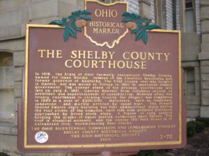
In 1819, the State of Ohio formally recognized Shelby County, named for Isaac Shelby, veteran of the American Revolution and former governor of Kentucky. The first county seat was located in Hardin, but was moved to Sidney in 1820 to centralize county government. The corner stone of the present courthouse was laid on July 4, 1881. George Maetzel from Columbus served as architect and superintendent of construction. Modeled after the county courthouse in Licking County, the project was completed in 1883 at a cost of $200,000. Materials, such as limestone, sandstone, and marble arrived by canal boat. The French Second Empire style building has four symmetrical sides facing the four points of the compass, each side with pillared porticoes approached by broad stone steps. A figure of Lady Justice holding the scales of equal justice surmounts each facade. The roof is classical mansard, and the center170-foot tower is of galvanized iron, encompassing four clocks.
In the 1820s a general store and grist mill were established on this site, where the famous Scioto-Sandusky Indian trail neared the Sandusky River. The settlement was first known as McNutt’s, later as Swope’s Corners. The village of Fort Seneca was surveyed January 14, 1836. Its name was derived from Gen. Harrison’s War of 1812 fort, which was located a few miles downstream.