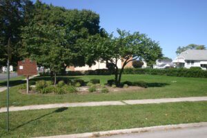
This monument marks the square of the village of Risdon founded 1832. The land was owned by John Gorsuch, who settled here with his family in a clearing along the Portage River in 1831. He had a plat of the area made by David Risdon, Seneca County surveyor, after who the town was named. This plat was officially recorded September 13, 1832. The village of Risdon had the first church and post office, and has the oldest house in Fostoria.
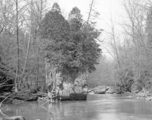
Near this site in October 1786 General Benjamin Logan with an army of 700 Kentucky volunteers camped on their way to destroy seven Indian towns in the Mad River Valley. During the night a renegade deserted the camp to warn the Indians. The army burned 200 cabins and 15,000 bushels of corn before returning. Later this site became an important survey point.
You are standing on the famous portage, carrying-place between the Cuyahoga and Tuscarawas rivers. The two streams and the portage across the watershed formed an early route between Lake Erie and the Ohio River. First the Indians, then French and English traders and trappers, and finally American settlers and travelers carried their canoes and packs across this narrow strip of land in passing, by way of the rivers, between northern and southern Ohio. The portage was a part of the defined boundaries in the treaties with the Indians made at Fort McIntosh (1785), Fort Harmar (1789), and Green Ville (1795). Use of the portage was discontinued in 1827 when the Ohio and Erie Canal was built along the old trail. Today, modern Akron streets–Portage Path and Manchester Road–follow the approximate route of the original portage.
Oldest Religious Congregation in north-central Ohio. First Methodist Sermon preached at the “spring” in 1809 by Rev. James Copus. Services then conducted in blockhouse, 1811; in first court house, 1813; at church home of Dr. William B. James, 1814; first church building located N.W. corner Park Avenue East and Adams, 1820; present site in 1870. All land donated by General James Hedges, a distinguished member.
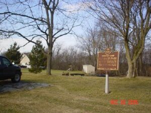
Constitution Park-Just N of Intersection of OH 725 and US 42
Spring Valley
, OH
In 1779 John Bowman’s forces followed the east bank to Glady Run, then north to the Indian village of Old Chillicothe. In 1780 and 1782 militia commanded by George Rogers Clark, and guided by Simon Kenton and Daniel Boone, crossed the river and camped two miles north of Caesar’s Creek, then marched on the villages near Springfield, Piqua, and Bellefontaine.
The Northwest Ordinance of 1787 defined the boundary of the northern and southern tier of states to be carved out of the Northwest Territory, as a line drawn east from the southernmost tip of Lake Michigan until it intersects Lake Erie. Controversy over the exact location of that line led to the 1834-1837 boundary dispute between the State of Ohio and Michigan Territory. Passions ran high as everyone on both sides of the boundary knew that a great port city (Toledo) would emerge in the disputed territory. President Andrew Jackson settled the dispute in 1836 when he signed an act that recognized the current border between Ohio and Michigan, giving Michigan 9,000 square miles of Upper Peninsula land and awarding the disputed strip of approximately 470 square miles to Ohio. Michigan then joined the nation as a state the following year.
As a member of the Connecticut Land Company, Judge Samuel Hinckley of North Hampton, Massachusetts purchased township 4N Range 13W of the Western Reserve in 1795 for a sum equivalent to 23 cents an acre. The township remained unsettled until Abraham Freeze was commissioned by Judge Hinckley in 1819 to survey the township into 100 plots of 160 acres each. In return for having the township, founded in 1825, named “Hinckley,” the judge gave land for two burying grounds and one-half acre for a public square. In 1919, upon the 101st anniversary of the “Great Hinckley Hunt,” where men from surrounding counties gathered on Christmas Eve to rid the township of wild animals, Judge Amos Webber spoke for the deceased Judge Hinckley: “When I last saw this country, it was a howling wilderness – by industry and frugality you and your ancestors have made these ever lasting hills and pleasant valleys blossom as the rose.”
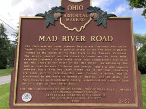
The first overland route between Dayton and Cincinnati was cut by Daniel Cooper in 1795 to provide access to the new town of Dayton, located at the mouth of the Mad River in the Symmes Purchase. The survey, entered into the record by Cooper and Dr. John Hole, extended Harmer’s Trace north from near Cunningham’s Station on the Mill Creek to the mouth of the Mad River, establishing the earliest road between Cincinnati and Dayton. This five-mile segment between David Road and State Route 725 is the last remaining traceable portion retaining this name. Cooper, a miller, was instrumental in the early settlement of Dayton, and Dr. Hole, the first physician in Montgomery County, established his cabin in 1796 on this part of Mad River Road.