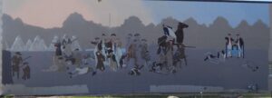
Native Americans inhabited and used much of the land in the Ohio valley as hunting grounds. As American settlers pushed west, conflicts resulted and attempts at peaceful settlement failed. Under political pressure, President George Washington resolved to subdue Indian resistance to American expansion in the Ohio country and appointed General Arthur St. Clair to lead the expedition. St. Clair’s troops camped on the Wabash River (just east of the Ohio-Indiana state line) after an exhausting two-month trek. The ill-prepared soldiers were no match for the forces of Miami, Shawnee, and Delaware Indians who attacked them at dawn of November 4, 1791. By the day’s end, warriors led by Little Turtle and Blue Jacket had killed or wounded nearly three-quarters of the American force-the worst-ever defeat of the U.S. Army by Native Americans in a single battle.
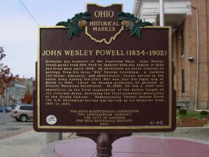
Scientist and explorer of the American West, John Wesley Powell moved from New York to Jackson with his family in 1838 and lived here until 1846. He developed an early interest in geology from his tutor “Big” George Crookham, a Jackson salt boiler, educator, and abolitionist. Powell served in the Union Army during the Civil War and lost his right arm at Shiloh in 1862. Later he became professor of geology at Illinois Wesleyan University. In 1869, he led a nine-man expedition in the first exploration of the entire length of the Colorado River, providing the first scientific description of the Grand Canyon. Subsequently Powell helped found the U.S. Geological Survey and served as its director from 1881 to 1894.
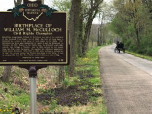
Republican congressman William M. McCulloch was one of the architects of the landmark Civil Rights Act of 1964, the first of three laws to recommit the nation to the cause of civil rights in the 1960s. “Bill” McCulloch was born near Holmesville to James H. and Ida McCulloch on November 24, 1901. Raised on the family farm, he attended local public schools, the College of Wooster, and, in 1925, earned his law degree from the Ohio State University. He married his childhood sweetheart Mabel Harris McCulloch (1904-1990) in 1927, after settling in Jacksonville to start his career during the Florida land-boom of the 1920s. It was in Jacksonville that the Deep South’s racial intolerance seared him. (Continued on other side)
SW corner of W Main Street and S Broadway Street (Public Square)
Greenville
, OH
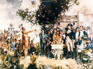
Following General Anthony Wayne’s victory at Fallen Timbers, members of the western tribes assembled at Fort Greene Ville to settle on terms of peace. Representatives of the Wyandot, Delaware, Shawnee, Ottawas, Chippewa, Ottawa, Patawatimi, Miami, Eel River, Wea, Piankeshaw, Kickapoo, and Kaskaskia signed the treaty on August 3, and agreed to cede claims to lands east of the Cuyahoga River to Fort Laurens in Tuscarawas County and south of a line running west to Fort Recovery. In return, the United States offered payment and annuities in the form of goods and ceded claim to most land north and west of the treaty line. This treaty marked the end of the Indian Wars in the Ohio Country, forsaking boundary violations by both parties, and established the official western border of the United States, opening much of Ohio for settlement.
A migration of Indians throughout Ohio began due to unstable conditions created by the American Revolution. The massacre of Christian Indians at the Moravian mission of Gnadenhutten in 1782 and Colonel William Crawford’s expedition against Wyandot and Delaware towns along the Sandusky fueled insecurities. Delaware, including a small group of Mingo Indians, abandoned the village of Helltown, five miles southwest of this site, and settled Greentown as early as 1783. Greentown, situated on an elevation on the Black Fork beyond the clearing behind this site, was presumably named for British loyalist, Thomas Green. John Chapman (Johnny Appleseed) had an amicable relationship with the Delaware, owned land throughout the Black Fork Valley, and was known to visit Greentown on his travels throughout Ohio. Other visitors to the village included the Shawnee Prophet; Munsee Delaware leader, Captain Pipe; and local preacher, James Copus.
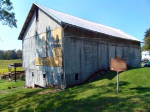
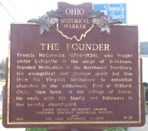
Francis McCormick (1764-1836), who fought under Lafayette at the siege of Yorktown, founded Methodism in the Northwest Territory. His evangelical and pioneer spirit led him from his Virginia birthplace to establish churches in the wilderness, first at Milford, Ohio, then here, at his village of Salem. He rests with his family and followers in the nearby churchyard.
Ripley was incorporated as the village of Staunton in 1812. Its name was changed in 1816 to honor General Eleazer Wheelock Ripley, a hero of the War of 1812. In the years before railroads, Ripley was a principal Ohio River shipping center. Also important were its extensive boat-building, tobacco, pork, and timber industries. Ripley too was the home of saw and planing mills, iron foundries, and a piano factory. Such varied commerce enabled Ripley to remain vibrant throughout the nineteenth century. Although noted as a port, Ripley is best remembered as an abolitionist stronghold. Many of its citizens, including Rev. John Rankin and John P. Parker, served as conductors on the famed “Underground Railroad.” The notoriety of Ripley’s anti-slavery network perhaps eclipsed that of nearby Cincinnati, earning the town a reputation as the “Black Hole of Abolitionism.” (Continued on side two)
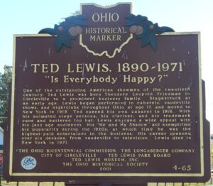
One of the outstanding American showmen of the twentieth century, Ted Lewis was born Theodore Leopold Friedman in Circleville to a prominent business family. Stagestruck at an early age, Lewis began performing in cabarets, vaudeville shows, and nightclubs throughout Ohio at age 17, and moved to New York in 1915. Ted opened his own cabaret in 1918. With his animated stage persona, his clarinet, and his trademark cane and battered top hat, Lewis enjoyed a wide appeal with his jazz age audiences. His “Me and My Shadow” act exemplified his popularity during the 1920s, at which time he was the highest-paid entertainer in the business. His career spanned over six decades, from vaudeville to television. Lewis died in New York in 1971.