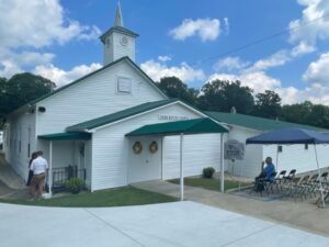
Union Baptist Church, established in 1819, is one of Ohio’s early Black churches. Its pastor and members were active on the Underground Railroad from that early date. Between the 1840s-1860s Black churches along the route to and from nearby Poke Patch assisted over 200 escaped slaves. Members met in their homes until able to obtain a log cabin (circa 1879) on a Blackfork farm. In 1919, a larger church was built on land given by The Cambria Clay Products Company. The adjacent cemetery has over fifty veterans from the Civil, Spanish American, both World, Korean, and Vietnam wars. Donald Russell Long, laid to rest in 1966, received a posthumous Congressional Medal of Honor. Union Baptist Church, the historic foundation of the Poke Patch-Blackfork community, celebrates an annual Church Anniversary to honor its legacy.
Orrville was founded in 1852 at the railroad crossing that would later serve the Pittsburgh, Fort Wayne and Chicago and the Columbus, Mount Vernon and Cleveland railroads. The town was named in honor of Judge Smith Orr, who was instrumental in bringing the railroad to Wayne County. Orr persuaded landowner Robert Taggart to partition ten acres into town lots. After buying out the land owned by fellow settlers Christian Horst, David Rudy, and Peter Perrine, Orr engaged Jesse Straughan to create the first plat map that centered the newly-formed town on the railroad crossing. Incorporated on May 9, 1864, Orrville prospered and attracted manufactories of all kinds. Orrville was the largest manufacturing town in Wayne County by 1873.
The township of Kinsman was purchased by John Kinsman of Lisbon, Connecticut, in 1799 from the Connecticut Land Company. Kinsman has been the home of many notable citizens, some of whom include: Philip P. Bliss (1838-1876) and James McGrannahan (1840-1907) were hymn composers and religious musical directors for the nationally-known evangelical Dwight L. Moody Revival Meetings held in Kinsman for thirty years in the late 1800s. Clarence Darrow (1857-1938) was a famous labor and criminal lawyer who grew up in Farmdale and in the “octagon house” in Kinsman. Darrow in probably best known for his work as a defense attorney in the Scopes Trial. (continued on reverse side)
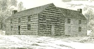
With the Division Act of 1800, the U.S. Congress divided the Northwest Territory at a line essentially the present boundary of Indiana and Ohio. The Indiana Territory stood west of the line. The name Northwest Territory was retained for the land east of the line and Chillicothe became its capital. The legislature for the territory convened in Chillicothe in November 1800. Since there were no public buildings in which the legislature could meet, its session was held in a two-story log house that stood on this site called “Abrams’ Big House.” It was so called for its owner, Basil Abrams. During the War of 1812, the building served as the barracks for the 19th U.S. Regiment of Infantry. Thereafter, it was known as the “old barracks” until it was razed circa 1840.
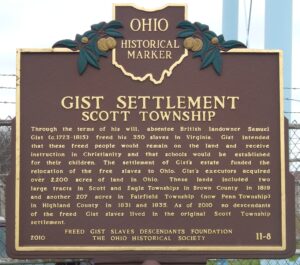
Through the terms of his will, absentee British landowner Samuel Gist (c. 1723-1815) freed his 350 slaves in Virginia. Gist intended that these freed people would remain on the land and receive instruction in Christianity and that schools would be established for their children. The settlement of Gist’s estate funded the relocation of the freed slaves to Ohio. Gist’s executors acquired over 2,200 acres of land in Ohio. These lands included two large tracts in Scott and Eagle Townships in Brown County in 1819 and another 207 acres in Fairfield Township (now Penn Township) in Highland County in 1831 and 1835. As of 2010, no descendants of the freed Gist slaves lived in the original Scott Township settlement.
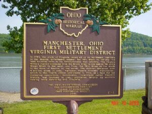
In 1784, the state of Virginia ceded all of its Northwest Territory to the federal government except for this tract to satisfy the land bounties owed to its Revolutionary War soldiers. The Virginia Military District extended from the Scioto River in the east to the Little Miami River in the west, and from the Ohio River on the south to the town of Kenton in the north. The District contained over 4 million acres of land. Nathaniel Massie founded Manchester, which is the fourth oldest settlement in Ohio, as a base for his surveying operations. Manchester, sometimes called Massie’s Station, was founded in 1791, populated largely by settlers coming from Kentucky and Virginia.
Following the American Revolution, the new Federal government, in need of operating funds, sold millions of acres of western lands to land companies. One such company, the Ohio Company of Associates, brought settlement to Marietta in 1788. Two years later, despite warnings of Native American hostility, an association of 36 Company members moved north from Marietta to settle “Big Bottom,” a large area of level land on the east side of the Muskingum River. The settlers were acquainted with Native American warfare, but even so, built an unprotected outpost. They did not complete the blockhouse, put pickets around it, or post a sentry. On January 2, 1791, a war party of 25 Delaware and Wyandot Indians from the north attacked the unsuspecting settlers, killing nine men, one woman, and two children. War raged throughout the Ohio Country until August 1794 when the tribes were defeated at the Battle of Fallen Timbers.
The surrounding 132 acres of land served as the Knox County Poor Farm (aka Knox County Infirmary and County Home) from 1842 to 1955. The farm was nearly self-sustaining. Able residents grew their own food, raised livestock, and did various chores as partial compensation for their care. In 1874, a fire in the original wood farmhouse resulted in one death. Public outrage and concerns for residents’ safety compelled the county commissioners to build a new “fireproof” poorhouse. The four-story brick building was constructed from 1875-1877. It is believed to be the last building designed by architect William Tinsley, utilizing a version of the Kirkbride Plan. This plan, conceived by Dr. Thomas Story Kirkbride, improved the layout of institutions and infirmaries for the well-being of their charges. (Continued on other side)