The completion of the Miami and Erie Canal passing through Napoleon in 1843 provided a way to receive manufactured goods, export farm products, and power local mills. The early industries of Napoleon utilized the canal as a source of reliable water power, which led to the development of a mid-19th-century industrial waterfront. Some of the local businesses that relied on the canal were Sayger’s Saw-mill (1843), John Ritter Flouring Mill (1850), Augustin Pilliod’s Napoleon Flouring Mill (1853), and the Napoleon Woolen Mill (1863). These mills used flumes, or artificial channels, to divert canal water to their water wheels. These brick-arch flumes were instrumental in bringing Napoleon into the national economy.
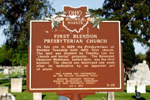
On this site in 1829 the Presbyterians of Blendon Township built their first church. The land was donated by Timothy Lee for “church and burial” purposes. The Reverend Ebenezer Washburn, buried here, was the first minister. The church was destroyed one week after its dedication by an apparent act of arson.
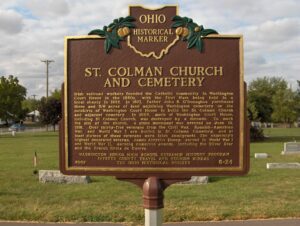
Irish railroad workers founded the Catholic community in Washington Court House in the 1850s, with the first Mass being held in a local shanty in 1852. In 1871, Father John B. O’Donoghue purchased three and 5/8 acres of land adjoining Washington cemetery on the outskirts of Washington Court House to build the St. Colman Church and adjacent cemetery. In 1885, much of Washington Court House, including St. Colman Church, was destroyed by a tornado. To mark the site of the church, a stone monument was erected on June 19, 1916. Over thirty-five veterans from the Civil War, Spanish-American War, and World War I are buried in St. Colman Cemetery, and at least sixteen of these veterans were Irish immigrants. The cemetery’s highest decorated veteran, James Aloysius Ducey, served in World War I and World War II, earning numerous awards, including the Silver Star and the French Croix de Guerre.
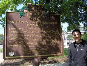
A progressive farmer, physician, and legislator, Norton S. Townshend lived in Avon from 1830 until his death. His introduction of field drainage tile significantly increased the productivity of Avon farmland. A well-educated country doctor, he served this district as a U.S. congressman (1851-1853) and later as an Ohio state senator. As a legislator Townshend, a member of the antislavery “Free Soil” Party, espoused civil rights for women and free blacks. Later he was instrumental in the founding of the Ohio Agricultural and Mechanical College in Columbus, serving on the first board and as its first professor of agriculture. In 1878, this land-grant college became Ohio State University, where Townshend Hall stands in honor of his founding role. He is interred in Avon’s mound cemetery.
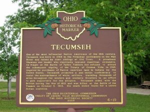
One of the most influential Native Americans of the 19th century, Tecumseh was born in 1768 in the Pickaway settlements on the Mad River and raised by older siblings at Old Town. A prominent Shawnee war leader who vigorously opposed American expansion, he fought at the Battle of Fallen Timbers but refused to attend the subsequent signing of the Treaty of Greene Ville in 1795. Angered by purchases of Native American land in Indiana by the United States, Tecumseh promoted a pan-Indian confederacy to resist the encroachment of white settlers, traveling thousands of miles throughout the western and southern frontiers in an effort to gain supporters for the alliance. Tecumseh sided with the British during the War of 1812 and was killed at the Battle of the Thames on October 5, 1813. His death ended hopes for a united Indian coalition.
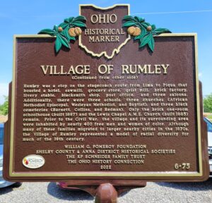
The Temple of Rumley Church is of one of two remaining buildings in what once was Rumley, a thriving African American community in Shelby County. On May 19, 1837, the village was surveyed for Amos Evans, who built his hewed log dwelling and store. Brothers Joel and George Goings (aka. Goens), freed black men from Monongalia County, Virginia, purchased 80 acres of land that same year. They settled with their families near Rumley in Van Buren Township along with other free men and women of color, including former slaves. Joel Goings erected the first brick house in 1841, using bricks from his own brickyard. By 1846, the Rumley community stretched over 7,000 acres and included the Collins, Redman, Williams, Davis, Lett, and Brown families. (Continued on other side)
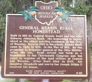
Built in 1816 by General Reasin Beall and his wife Rebecca Johnston Beall, the homestead is recognized as the oldest existing residence in the City of Wooster. Born in 1769 in Maryland, Reasin Beall came to Ohio in 1801. In the War of 1812, he was promoted to brigadier general of the Ohio militia. After the war, Beall served one term as a Republican to the Thirteenth Congress and ten years as a register of the land offices at Canton and Wooster. After Beall died in 1843, his daughter Elizabeth and son-in-law Joseph Stibbs II received his house.
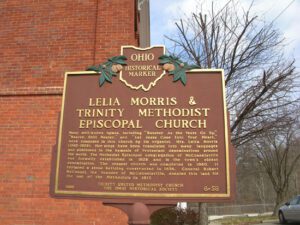
Many well-known hymns, including “Sweeter As the Years Go By,” “Nearer, Still Nearer,” and “Let Jesus Come Into Your Heart,” were composed in this church by its organist, Mrs. Lelia Morris (1862-1929). Her songs have been translated into many languages and published in the hymnals of Protestant denominations around the world. The Methodist Episcopal congregation of McConnelsville was formally established in 1826 and is the town’s oldest denomination. The present church was completed in 1860. It replaced a stone building constructed in 1836. General Robert McConnel, the founder of McConnelsville, donated this land for the use of the Methodists in 1817.