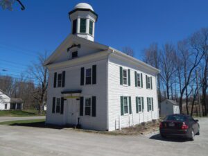
The most notable feature of Mantua Center is the “Village Green,” which harkens back to the New England heritage of Mantua Center’s early settlers. The Green sets upon land donated by Hezekiah Nooney Sr. and was important to both the social and commercial interests of the town. The businesses located here were a furniture and cabinet maker’s shop, harness shop, blacksmith shop, post office, tannery, ashery, dry goods store, and distillery. The Methodist Episcopal Church, now the Mantua Civic Center, stands at the southwest corner of the green. Eastlawn cemetery, with a burial that dates to 1816, sits along the south border. The cemetery serves as the final resting place for soldiers of several wars, including the American Revolution, as well as many other early citizens. In 1835 Horace Sizer constructed the stone wall around the cemetery adjacent to Mantua Center Road. [continued on other side]
In 1805, for $1.50 an acre, Jacob Miller purchased this property in the Congressional Land Office in Chillicothe, capital of the new state of Ohio. He and Somerset co-founder John Finck then each built a tavern on either side of town along the Zane’s Trace, laid out along existing Indian trails in 1796-1797 and Ohio’s first major thoroughfare. Finck built his home and tavern in 1807 and Miller his shortly after. From 1800 to 1815, Zane’s Trace saw significant traffic between the established eastern states and the newly opened Northwest Territory. A perpetual stream of emigrants rolled westward, giving constant occupation to hundreds of tavern-keepers. Besides operating his tavern and farming, Jacob Miller was a public servant. In 1809, he was appointed Overseer of the Poor as there was a need to “bind out” poor children to families who could take care of them. [continued on other side]
When inventor and entrepreneur Garrett Augustus Morgan sold his Traffic Signal patent to General Electric in 1923, he used the $40,000 to purchase a 121-acre farm in Huron County in 1924. Advertising “a village of our own,” Morgan established the Wakeman Country Club — one of Ohio’s early African American recreation clubs — and offered 247 lots for $60 each in “Wakeman Heights.” Located near the intersection of State Route 60 and Chenango Road, the development provided country pleasures to Blacks excluded from the Country Club lifestyle. Club membership, included in the purchase of a lot, offered fishing, hunting, swimming, and horseback riding. A restaurant, dance hall, and amphitheater provided cultural and boxing events. The club waned during World War II and no buildings from the once-thriving Wakeman Country Club remain.
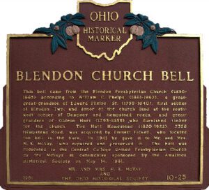
This bell came from the Blendon Presbyterian Church (1830-1865) according to William C. Phelps (1881-1967), a great-great-grandson of Edward Phelps Sr. (1759-1840), first settler of Blendon Twp. and donor of the church land at the southwest corner of Dempsey and Hempstead roads, and great-grandson of Gideon Hart (1795-1859) who furnished timber for the church. The Hart Homestead (1820-1922), 7328 Hempstead Road, was acquired by Emmett Fickell, who located the bell in the barn. In 1941 he gave it to Mr. and Mrs. M.R. McVay, who repaired and preserved it. The bell was presented to the Central College United Presbyterian Church by the McVays at ceremonies sponsored by the Amalthea Historical Society on May 14, 1981.
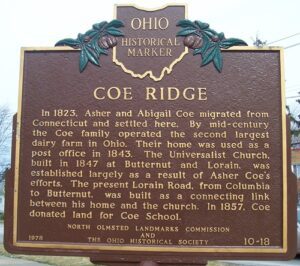
In 1823, Asher and Abigail Coe migrated from Connecticut and settled here. By mid-century the Coe family operated the second largest dairy farm in Ohio. Their home was used as a post office in 1843. The Universalist Church, built in 1847 at Butternut and Lorain, was established largely as a result of Asher Coe’s efforts. The present Lorain Road, from Columbia to Butternut, was built as a connecting link between his home and the church. In 1857, Coe donated land for Coe School.
Rossville was settled in April 1801 shortly after the U.S. Government initiated land sales west of the Great Miami River. Its original proprietors–John Sutherland, Henry Brown, Jacob Burnet, James Smith and William Ruffin–named the town in honor of Pennsylvania Senator James Ross (1762-1847), who favored Ohio statehood and advocated free navigation of inland rivers. These founders envisioned Rossville as a shipping port for the rapidly growing population of farmers settling west of the Great Miami. The most practical outlet for their products was by flatboat down the Great Miami, Ohio, and Mississippi rivers to New Orleans. The town of Rossville was founded in 1804, the year after the Louisiana Purchase, which made the Mississippi River a United States possession. (Continued on other side)
In the first years of the twentieth century, Athens’ citizens formed a new National Guard company. The guardsmen initially held drill at the Campbell Block on Court Street, but soon the Athens Commercial Club began advocating for an armory from the Ohio National Guard. In 1912, the Armory Board approved the request. Plans were drawn up for the armory and the Guard purchased land from the Athens Brick Company at the foot of Shale Hill. Construction began in the spring of 1915 and the Armory opened in December. In March of 1917, the city held a dedication ceremony and parade. Before World War I, the Athens Armory housed Company L and the Machine Gun Company, both part of the 7th Infantry Regiment, Ohio National Guard. (Continued on other side)
Union Baptist Church, established in 1819, is one of Ohio’s early Black churches. Its pastor and members were active on the Underground Railroad from that early date. Between the 1840s-1860s Black churches along the route to and from nearby Poke Patch assisted over 200 escaped slaves. Members met in their homes until able to obtain a log cabin (circa 1879) on a Blackfork farm. In 1919, a larger church was built on land given by The Cambria Clay Products Company. The adjacent cemetery has over fifty veterans from the Civil, Spanish American, both World, Korean, and Vietnam wars. Donald Russell Long, laid to rest in 1966, received a posthumous Congressional Medal of Honor. Union Baptist Church, the historic foundation of the Poke Patch-Blackfork community, celebrates an annual Church Anniversary to honor its legacy.