Ephraim Root (1762-1825), a wealthy Connecticut lawyer, was one of 57 investors in the Connecticut Land Company and served as its secretary and agent. In 1795, this group purchased three million acres of land in the Western Reserve. Root held interest in 100,000 acres, including Township 2 in Range VIII, which he named Rootstown. In 1800, Root traveled by horseback with his helper Henry Davenport and surveyor Nathaniel Cook to divide the township into 48 sections, reserving Lot 6 for his own use.
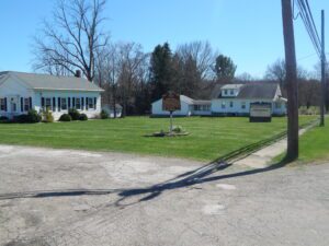
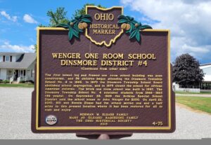
Dinsmore Township School District #4 was formed in 1865following a decision by the township’s board of education that a school would be built in the center of every four sections of land, or every four square miles. This placement of school buildings gave township children the opportunity to attend school close to home and the chance at receiving a public education up to the eighth grade, Nine districts were created for the children of white households, and an additional district was formed to educate the children of the African American families, for a total of ten districts in the township. On June 11, 1866, the Dinsmore Township School Board purchased land from George Wenger to build the District #4 school near the intersection of Ohio Route 274 and Wenger Road. (Continued on other side)
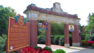
Manasseh Cutler, Rufus Putnam, Winthrop Sargeant, and Benjamin Tupper of the Ohio Company conceived Ohio University, which was encouraged by the Ordinance of 1787 and the Northwest Territorial Legislature in 1799, incorporated as the American Western University in 1802, and chartered by the Ohio State Legislature on February 18, 1804. The university is the first institution of higher learning in the Northwest Territory, second west of the Allegheny Mountains, and the first in the United States to be endowed with land by the government with proceeds used to pay for its operations-revenue from two townships was set aside to support the university. Opened on June 1, 1809, as an academy with three students, Ohio University awarded its first undergraduate degrees in 1815.
Frances Rappaport Horwich was born in Ottawa on July 16, 1907, the daughter of Sam Rappaport, an Austrian immigrant who operated a general store, and Rosa Gratz Rappaport, a Russian immigrant. The youngest of six children, she attended the Ottawa elementary school and graduated from Ottawa High School in 1924. After high school, she attended the University of Chicago where she earned a bachelor’s degree in philosophy and taught first grade for three years. “Miss Frances,” as she was called, then earned a master’s degree from Columbia University in 1933 and a Ph.D. in 1942 from Northwestern University. From 1942 to 1952, she was involved in teaching and education development. The basic education she received in the Ottawa schools enabled her to achieve great skills and abilities. [continued on other side]
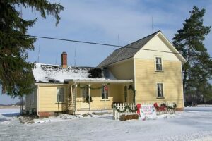
Heritage Farm is a typical mid-19th century farm of the Ohio Western Reserve and has been restored and preserved. The original parcel of land consisted of 325 acres, which was purchased by David Berdan in 1818. The farmstead has been home to Abram and Sarah Berdan, William and Rachel Pitkin, George and Julia Tibbitts, and Peter and Mary Groening. The Heritage Farm Museum site consists of 4 acres with a house, privy, carriage house, corncrib, granary, equipment shed, barn, milk house, and chicken house, and was open to the public on July 1, 2000.
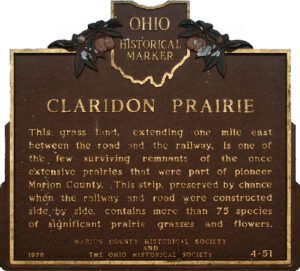
This grass land, extending one mile east between the road and the railway, is one of the few surviving remnants of the once extensive prairies that were part of pioneer Marion County. This strip, preserved by chance when the railway and road were constructed side by side, contains more than 75 species of significant prairie grasses and flowers.
This congregation was organized January 9, 1820 by 11 charter members. In 1837 the structure was completed on land reserved for religious purposes on the first Maumee plat. A British gun battery stood on the site in the War of 1812. Additions to the building were made in 1922, 1951, and 1968. Dr. Horatio Conant, pioneer teacher, merchant, physician, and politician, was for 59 years a member and officer.
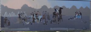
Native Americans inhabited and used much of the land in the Ohio valley as hunting grounds. As American settlers pushed west, conflicts resulted and attempts at peaceful settlement failed. Under political pressure, President George Washington resolved to subdue Indian resistance to American expansion in the Ohio country and appointed General Arthur St. Clair to lead the expedition. St. Clair’s troops camped on the Wabash River (just east of the Ohio-Indiana state line) after an exhausting two-month trek. The ill-prepared soldiers were no match for the forces of Miami, Shawnee, and Delaware Indians who attacked them at dawn of November 4, 1791. By the day’s end, warriors led by Little Turtle and Blue Jacket had killed or wounded nearly three-quarters of the American force-the worst-ever defeat of the U.S. Army by Native Americans in a single battle.