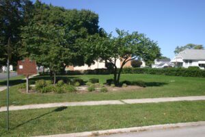
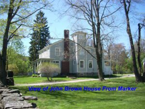
This monument marks the square of the village of Risdon founded 1832. The land was owned by John Gorsuch, who settled here with his family in a clearing along the Portage River in 1831. He had a plat of the area made by David Risdon, Seneca County surveyor, after who the town was named. This plat was officially recorded September 13, 1832. The village of Risdon had the first church and post office, and has the oldest house in Fostoria.
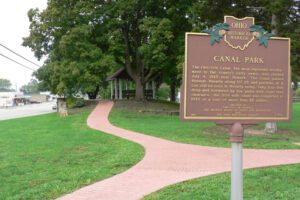
The Ohio-Erie Canal, the most important development in the county’s early years, was started July 4, 1825 near Newark. The canal passed through Waverly along US 23 and portions of it can still be seen in Waverly today. Only four feet deep and bordered by tow paths with eight feet clearance, the 309 mile canal was completed in 1833 at a cost of more than $7 million.
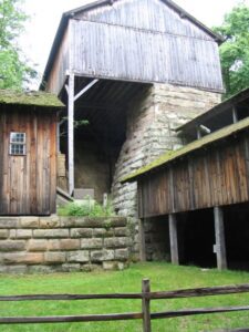
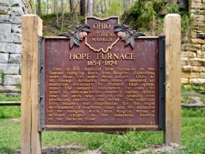
One of 69 charcoal iron furnaces in the famous Hanging Rock Iron Region. Extending more than 100 miles, from Logan, Ohio, to Mt. Savage, Kentucky, this area contained all materials necessary to produce high grade iron. The industry flourished for over fifty years in the mid-nineteenth century, during which time the area was one of the leading iron producing centers of the world. The charcoal iron industry was an important factor in the development of southern Ohio, and the romance of the Hanging Rock Iron Region forms a brilliant chapter in the industrial history of the Buckeye State.
One of the 69 charcoal iron furnaces in the famous Hanging Rock Iron Region. Extending more than 100 miles from Logan, Ohio to Mt. Savage, Kentucky this area contained all materials necessary to produce high grade iron. The industry flourished for over 50 years in mid-nineteenth century during which time the area was one of the leading iron producing centers of the world. The charcoal iron industry was responsible for the rapid development of southern Ohio and the romance of the Hanging Rock Iron Region forms a brilliant chapter in the industrial history of the Buckeye State.
You are standing on the famous portage, carrying-place between the Cuyahoga and Tuscarawas rivers. The two streams and the portage across the watershed formed an early route between Lake Erie and the Ohio River. First the Indians, then French and English traders and trappers, and finally American settlers and travelers carried their canoes and packs across this narrow strip of land in passing, by way of the rivers, between northern and southern Ohio. The portage was a part of the defined boundaries in the treaties with the Indians made at Fort McIntosh (1785), Fort Harmar (1789), and Green Ville (1795). Use of the portage was discontinued in 1827 when the Ohio and Erie Canal was built along the old trail. Today, modern Akron streets–Portage Path and Manchester Road–follow the approximate route of the original portage.
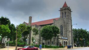
Oldest Religious Congregation in north-central Ohio. First Methodist Sermon preached at the “spring” in 1809 by Rev. James Copus. Services then conducted in blockhouse, 1811; in first court house, 1813; at church home of Dr. William B. James, 1814; first church building located N.W. corner Park Avenue East and Adams, 1820; present site in 1870. All land donated by General James Hedges, a distinguished member.
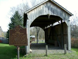
This covered bridge, over Middle Run, Elkrun Township, Columbiana County, is the shortest covered bridge in the United States still standing on a once-used public highway, having a clear span of 19 feet and 3 inches. It is an example, rarely found covered, of the simplest, most basic truss design, the two-panel king post truss. It has withstood the rigors of time and traffic since the 1870s and stands in eloquent testimony of the fine craftsmanship of the early Ohio bridge builders.
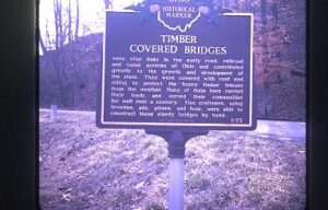
This bridge, spanning Brush Creek in Brush Creek Township, Scioto County, was erected in 1874 by the Smith Bridge Company of Toledo, Ohio. Robert W. Smith was granted patents for timber trusses in 1867 and 1869, and the design for this bridge is a Smith patented truss. The supplemental arches were added in 1896. Original length of 200 feet had been shortened to its present 171 feet. This plaque has been erected to give due honor to these early timber covered bridge builders and to the men of the community who so ably assisted them. [This side of the marker contains a bridge illustration in the upper left corner]