Colonel Ebenezer Zane, one of the founders of Wheeling, laid out the village that became Bridgeport in 1806 on the site of Fort Kirkwood (1789). Originally named Canton, it acquired its present name after the bridge to Wheeling Island was built. The arrival of the National Road in 1818 made the growing town a major portal into the state of Ohio for westbound emigrants, adding to its importance as a port for Ohio River traffic. With the advent of railroads and, later, transcontinental highways, Bridgeport continues to serve as Ohio’s “Gateway to the West.”
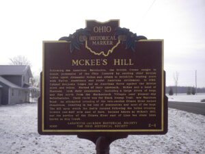
Following the American Revolution, the British Crown sought to retain possession of the Ohio Country by sending chief British Indian Agent Alexander McKee and others to establish trading posts with Native Americans and resist American settlement. In 1786, Colonel Benjamin Logan led an American force against the British posts and tribes. Warned of their approach, McKee and a band of Shawnee, took their possessions, including a large drove of hogs, and fled north from the Mackachack Villages near present-day Bellefontaine. Their route was the Black Swamp Trail, now Napoleon Road. An attempted crossing of the rain-swollen Ottawa River turned disastrous, resulting in the loss of possessions and most of the hogs. The hill upon which the party camped following the failed crossing, located one half mile east of here, became known as McKee’s Hill, and the portion of the Ottawa River east of Lima has since been known as Hog Creek.
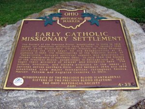
The Society of the Precious Blood, established in Italy in 1815, began its American ministry here in Peru in January 1844, led by Swiss missionary Father Francis de Sales Brunner. Continuing the work begun by the Redemptorists at St. Alphonse in 1833, the Missionaries of the Precious Blood, or “Sanguinists,” brought spiritual support and education to German immigrants in northern Ohio. In July 1844 the Sisters of the Precious Blood, established in Switzerland in 1834, began their ministry of prayer and education here. The priests, brothers, and sisters attended to the needs of parishes across northern Ohio, and between 1844 and 1856 established nine major foundations throughout Seneca, Mercer, Putnam and Auglaize Counties in Ohio.
On this site the Ohio & Erie Canal flowed south and down-level under the Market Street Bridge. Nearby Pawpaw Creek and the canal culturally divided the Swiss settlers to the west in Basil and the Virginia pioneers to the east in New Market (Baltimore by 1833). In March 1825, the “Twin Cities” were “dedicated” one day apart and energized a feud that often erupted at the bridge where “the boys of one village entered the other at their peril and where the worst of the intervillage fights were held.” The rivalry stretched well into the twentieth century and was arguably terminated with an uneasy consolidation of the two towns in 1947.
SW corner of W Main Street and S Broadway Street (Public Square)
Greenville
, OH
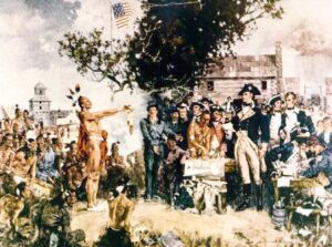
Following General Anthony Wayne’s victory at Fallen Timbers, members of the western tribes assembled at Fort Greene Ville to settle on terms of peace. Representatives of the Wyandot, Delaware, Shawnee, Ottawas, Chippewa, Ottawa, Patawatimi, Miami, Eel River, Wea, Piankeshaw, Kickapoo, and Kaskaskia signed the treaty on August 3, and agreed to cede claims to lands east of the Cuyahoga River to Fort Laurens in Tuscarawas County and south of a line running west to Fort Recovery. In return, the United States offered payment and annuities in the form of goods and ceded claim to most land north and west of the treaty line. This treaty marked the end of the Indian Wars in the Ohio Country, forsaking boundary violations by both parties, and established the official western border of the United States, opening much of Ohio for settlement.
With the signing of the Treaty of Paris in 1783, England lost the American Revolution and ceded to its former colonies land from the Atlantic Ocean to the Mississippi River. By this time, pioneer settlers had reached the eastern bank of the Ohio River, but the Ohio Country, located west and north of the river, was still considered Indian Territory. The Indian tribes desperately defended their hold on this land. On August 20, 1794, United States forces led by Major General Anthony Wayne defeated an Indian alliance at the Battle of Fallen Timbers fought near modern-day Toledo. One year later, on August 3, 1795, the largest assemblage of northwestern Indian representatives at a peace settlement signed the Treaty of Greene Ville, which effectively ceded all land south of the Greene Ville Treaty line to the Americans. The Fort Laurens site was a reference point in the Treaty line. The Ohio Country was then rapidly settled, and in 1808, Tuscarawas County was organized.
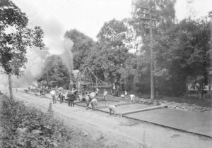
On this site, the Miami and Erie Canal, that came north from Cincinnati and the Ohio River, intersected with the Wabash and Erie Canal that came from Fort Wayne and Evansville, Indiana. From this point, which became the town of Junction, the canals proceeded as one to Defiance, Toledo, and Lake Erie. From the 1830s to the 1870s, the canals played a key role in the settling of Paulding County, an area that was once a part of the Great Black Swamp. They held the promise of easier and quicker passenger transportation and commodity shipping and Junction became a landmark for fugitive slaves escaping to Canada. Once a thriving and growing community, the village of Junction became a forgotten historical note with the passing of the canal era and the coming of the railroads. Today, the Buckeye Trail and North County Trail follow the canal path through Paulding County.
Early in the War of 1812, Gen. Wm. Hull, commander of Ohio troops, ordered Col. James Findlay to open a road from Ft. McArthur on the Scioto River to Blanchard’s Fork. Under Findlay, a stockade 50 yards square, with a blockhouse at each corner, was erected here and named in his honor. The fort was used as a supply depot.