Evansport is named after brothers Amos and Albert G. Evans who, with Jacob Coy, had the village surveyed next to the Tiffin River on December 14, 1835. The “port” suffix in Evansport’s name reflects the river’s significance as a transportation thoroughfare. Evansport’s early growth was spurred by its mills powered by the Tiffin River. The mills provided settlers with lumber for buildings and supplied flour and cornmeal for sustenance and commerce. Settlers who poured into Williams County’s northern townships in the 1830s agitated debate about moving the county seat to a more centralized location. Evansport was platted as a possible site for the county seat. The Williams County seat was moved to Bryan in 1840 and in 1845 Defiance County was created, leaving Evansport on the Williams-Defiance county line.
Completed in 1837, the limestone lock nine served as a catalyst for the growth of Piqua. The lock helped connect the village to Cincinnati (1837) and Toledo (1845) by way of the Miami and Erie Canal. German immigrants traveled up the canal from Cincinnati and settled within a five-block area of the lock. Industries used the lock as a source of water power and developed products as diverse as flannel, flour, and flax seed. Lock nine remained as a functioning part of the canal until its destruction during the flood of 1913.
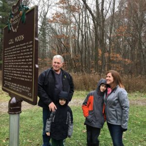
Two Deputy U.S. General Land Office Surveyors traversed Goll Woods: Benjamin Hough in 1815 and Captain James Riley in 1821. Hough (1772-1819) established the Michigan Meridian in 1815 and was county and state office holder in Ohio. Riley’s life was more tumultuous. Riley (1777-1840) captained the merchant ship Commerce, which wrecked off the Saharan coast in 1815. Riley and crew were enslaved for four months until ransomed by British diplomat William Willshire. In 1817, Riley published a famous account of his time in North Africa, and, in 1819, was appointed a surveyor by Surveyor General Edward Tiffin. Moving to Northwest Ohio, Riley named the village he founded in 1822, Willshire, for his deliverer. Riley returned to New York in 1826 and to the sea, where he died. Riley’s book went through more than twenty editions by 1860 and Abraham Lincoln credited the account as one that influenced him deeply.
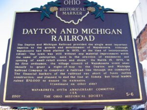
The Dayton and Michigan Railroad provided the single most important impetus to the growth and development of Wapakoneta. Although Wapakoneta had been platted in 1833, at the time of incorporation (1848), “the town was still without any material improvement worth the name of enterprise, save in the erection of residences and opening of small retail stores and shops.” On March 15, 1854, in its first ordinance, the village council of Wapakoneta voted unanimously to grant a right-of-way to the Dayton and Michigan Railroad Company to construct a railroad line through the community. The financial backers of the railroad ran short of funds during construction, and planned to end the line at Sidney, but local leaders raised $70,000 to ensure its extension. (Continued on other side)
The Carthagena Black Cemetery (Union Cemetery) is a remnant of approximately 70 documented rural black and mulatto settlements established in Ohio before the Civil War. In the charged atmosphere following race riots in Cincinnati in 1829, Quaker abolitionist Augustus Wattles led 15 black families north in 1835. In 1837 Wattles purchased 189 acres where the cemetery is located. Headstones date from 1840, the year mulatto Charles Moore, platted the Village of Carthagena. Wattles and mulatto clergymen Sam Jones and Harrison Lee were Underground Railroad conductors. Wattles moved to Kansas in 1855. By 1860, more than 100 black and mulatto families, totaling 600 people, owned over 10,000 acres. (Continued on other side)
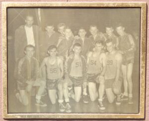
Team photograph here Standing, L to R: Coach C. Norris Simpson, Donald Alt, Bill Ziegler, Roy Meyer, Jerry Kuhlman, Karl Inkrott, Vern Schroeder, Mel Lammers Kneeling, L to R: Joe Lammers, Junior McDonald, Frank Schroeder, Ralph (Skip) Meyer, Dick Barlage Team manager: Charles Warnimont Cheerleaders: Betty Lou Meyer, Agnes Riepenhoff, Clara Schroeder, Audrey Wischmeyer School colors: Blue and Gold “You have got to have the boys and I had the boys” –Coach C. Norris Simpson
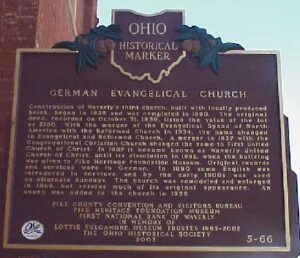
Construction of Waverly’s third church, built with locally produced brick, began in 1859 and was completed in 1860. The original deed, recorded on October 31, 1859, listed the value of the lot as $180. With the merger of the Evangelical Synod of North America with the Reformed Church in 1934, the name changed to Evangelical and Reformed Church. A merger in 1957 with the Congregational Christian Church changed the name to First United Church of Christ. In 1987 it became known as Waverly United Church of Christ, until its dissolution in 1992, when the building was given to Pike Heritage Foundation Museum. Original records and services were in German. In 1890 some English was introduced in services, and by the early 1900s was used on alternate Sundays. The church was remodeled and enlarged in 1869, but retains much of its original appearance. An annex was added to the church in 1959.
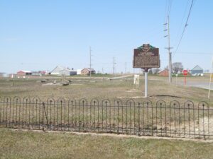
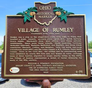
The Temple of Rumley Church is of one of two remaining buildings in what once was Rumley, a thriving African American community in Shelby County. On May 19, 1837, the village was surveyed for Amos Evans, who built his hewed log dwelling and store. Brothers Joel and George Goings (aka. Goens), freed black men from Monongalia County, Virginia, purchased 80 acres of land that same year. They settled with their families near Rumley in Van Buren Township along with other free men and women of color, including former slaves. Joel Goings erected the first brick house in 1841, using bricks from his own brickyard. By 1846, the Rumley community stretched over 7,000 acres and included the Collins, Redman, Williams, Davis, Lett, and Brown families. (Continued on other side)