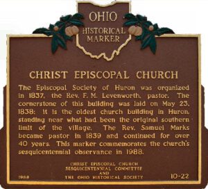
The Episcopal Society of Huron was organized in 1837, the Rev. F. M. Levenworth, pastor. The cornerstone of this building was laid May 23, 1838; it is the oldest church building in Huron, standing near what had been the original southern limit of the village. The Rev. Samuel Marks became pastor in 1839 and continued for over 40 years. This marker commemorates the church’s sesquicentennial observance in 1988.
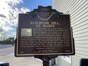
Established in 1823, the pioneer settlement of St. Marys became a thriving 19th century milling center following completion of the Miami & Erie Canal in 1845. The Reservoir Mill, built by Scott, Linzee & Co. in 1847, led this period of industrial growth as the first mill in St. Marys powered by the canal’s water. Robert B. Gordon purchased it in 1855 and in 1896 the mill passed to his son, Robert B. Gordon Jr., who formed the firm Gordon, Hauss & Folk. Producing “Purity” and “Pride of St. Marys” flour, Gordon, Hauss & Folk owned the mill until 1955. The mill was used as a grain elevator until 1972, then as a storage facility for the next 40 years. (Continued on other side)
The most notable feature of Mantua Center is the “Village Green,” which harkens back to the New England heritage of Mantua Center’s early settlers. The Green sets upon land donated by Hezekiah Nooney Sr. and was important to both the social and commercial interests of the town. The businesses located here were a furniture and cabinet maker’s shop, harness shop, blacksmith shop, post office, tannery, ashery, dry goods store, and distillery. The Methodist Episcopal Church, now the Mantua Civic Center, stands at the southwest corner of the green. Eastlawn cemetery, with a burial that dates to 1816, sits along the south border. The cemetery serves as the final resting place for soldiers of several wars, including the American Revolution, as well as many other early citizens. In 1835 Horace Sizer constructed the stone wall around the cemetery adjacent to Mantua Center Road. [continued on other side]
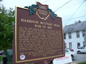
The first road through Marion County followed the Scioto Trail of the Native Americans. This 120-foot wide strip through Wyandot territory led from Lower Sandusky (Fremont) to the Greenville Treaty Line. A confederation of Ohio tribes ceded it to the United States at the Treaty of Brownsville, Michigan, in 1808. During the War of 1812, the troops of General William Henry Harrison’s Army of the Northwest traveled this road en route to Fort Meigs and the British fort at Detroit, using it to transport supplies to the army and to the chain of forts and blockhouses that protected the road. After the American victory, this area was opened for settlement by the 1817 Treaty of the Maumee Rapids, and soldiers who discovered the area while traveling the Military Road were among the first settlers. (continued on other side)
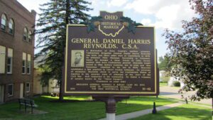
A descendent of Knox County’s earliest pioneers, Confederate Brigadier General Daniel Harris Reynolds was born just three miles west of Centerburg in 1832. He attended Ohio Wesleyan University in Delaware, where he became a close friend of Otho Strahl, another Ohio born Confederate general. Reynolds taught school in Ohio before studying law in Iowa and then Tennessee. Admitted to the bar in 1858, Reynolds established a law practice in Chicot County Arkansas. An advocate of secession, Reynolds chose to serve the Confederate States of America in his adopted state of Arkansas at the start of the Civil War. Well respected in his community, he raised a company of cavalry known as the “Chicot Rangers.” (Continued on other side)
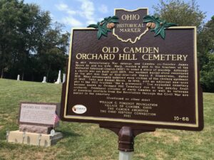
In 1817, Revolutionary War veteran and Camden co-founder James Moore Sr. and his wife, Mary, deeded a plot to the trustees of the Methodist Episcopal Church (MEC) to erect a place of worship. Although a church was not built until 1825, the earliest burial stone recovered on the plot was that of five-year-old Simon P. Zimmerman, dated 1818. Many subsequently interred were victims of the cholera epidemic of 1849. Felix and Rachel Marsh, in 1852, sold an adjacent one-acre plot to the MEC trustees “for a graveyard.” The expanded cemetery became known as Orchard Hill Cemetery due to the nearby fruit orchards. Prominent citizens of early Camden as well as veterans of American conflicts from the Revolution through the Civil War are buried in the cemetery. (Continued on the other side)
In recognition of its noteworthy representation of the history, culture, and architecture of the Western Reserve, Burton Village’s Historic District was placed on the National Register of Historic Places in 1974. The Historic District, an area of approximately 20 acres surrounding the Village Green and along streets at the north end of the Green, includes 15 buildings of historical significance built between 1815 and 1891. Preserved within the District are commercial and public buildings and private dwellings that reflect the cultural and architectural development of a village of the Western Reserve of Ohio during the 19th century. Buildings in the predominant architectural styles of the 19th century are all represented in the Historic District, including Western Reserve, Greek Revival, Second Empire, Italianate, and Queen Anne. [Continued on other side]
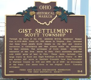
Through the terms of his will, absentee British landowner Samuel Gist (c. 1723-1815) freed his 350 slaves in Virginia. Gist intended that these freed people would remain on the land and receive instruction in Christianity and that schools would be established for their children. The settlement of Gist’s estate funded the relocation of the freed slaves to Ohio. Gist’s executors acquired over 2,200 acres of land in Ohio. These lands included two large tracts in Scott and Eagle Townships in Brown County in 1819 and another 207 acres in Fairfield Township (now Penn Township) in Highland County in 1831 and 1835. As of 2010, no descendants of the freed Gist slaves lived in the original Scott Township settlement.