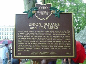
Labeled “Union Square” on the first village maps, block 12 of the City of Bellaire was formed by joining portions of the Harris and Rodefer Farms in 1857. Used for tent shows, circuses, political meetings, and playing baseball, the land during the Civil War was used as a canteen for feeding Union recruits from nearby Camp Jefferson. Stonemasons cut sandstone blocks here that make up “Great Stone Viaduct” railroad bridge. A steam derrick and stable for horses that helped to move the sandstone to the bridge’s construction site were also placed temporarily on this land. In 1882, a monument was erected to honor Civil War veterans as “Union Square” became a city park. Former President Theodore Roosevelt delivered a speech here to the citizens of Bellaire in 1912.
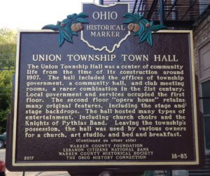
The Union Township Hall was a center of community life from the time of its construction around 1907. The hall included the offices of township government, a community hall, and club meeting rooms, a rarer combination in the 21st century. Local government and services occupied the first floor. The second floor “opera house” retains many original features, including the stage and stage backdrops. The hall hosted many types of entertainment, including church choirs and the Knights of Pythias Band. Leaving the township’s possession, the hall was used by various owners for a church, art studio, and bed and breakfast.(Continued on other side)
801 E. Pete Rose Way, Bicentennial Commons at Sawyer Point
Cincinnati
, OH
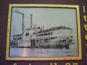
In 1862, less than a mile upriver from this marker, the John Lithoberry Shipyard in Cincinnati constructed the Sultana, a 260-foot, wooden steam transport. At the end of the Civil War, the U.S. Government contracted the Sultana to transport recently freed Federal prisoners north from Confederate stockades. During the night of April 27, 1865, while carrying over 2,300 Union soldiers – over six times its capacity of 376 passengers – a steam boiler aboard the Sultana exploded. The ship erupted in a massive fireball and sank in the cold, flood-swollen Mississippi River ten miles north of Memphis, Tennessee. Over 1,700 individuals died – some 200 more than those lost aboard the Titanic in 1912 – in what remains the worst maritime disaster in American history. Of the total casualties, Ohio lost the most of any state, with 791 dead. Indiana lost 491 persons, with Kentucky suffering 194 dead. It is estimated that, of the Ohio casualties, over fifty were Cincinnatians.
In April 1784, the Continental Congress adopted the Report of Government for the Western Territory, a broad plan drafted primarily by Thomas Jefferson for organizing the United States’ new western lands that were ceded by the states and purchased from Native Americans. One of the most far-reaching legislative acts in American history, the resulting Land Ordinance of 1785, passed on May 20th, established the public land system by which all federal land was surveyed and distributed. The Ordinance established a rectilinear survey system that divided land into townships of six miles square aligned by north-south and east-west baselines, and set aside certain lands for Revolutionary War veterans and for public schools.
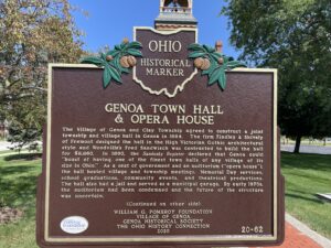
The Village of Genoa and Clay Township agreed to construct a joint township and village hall in Genoa in 1884. The firm Findley & Shively of Fremont designed the hall in the High Victorian Gothic architectural style and Woodville’s Fred Sandwisch was contracted to build the hall for $8,860. In 1890, the Sandusky Register declared that Genoa could “boast of having one of the finest town halls of any village of its size in Ohio.” As a seat of government and an auditorium (“opera house”), the hall hosted village and township meetings, Memorial Day services, school graduations, community events, and theatrical productions. The hall also had a jail and served as a municipal garage. By early 1970s, the auditorium had been condemned and the future of the structure was uncertain. (Continued on other side)
Lucas County was named for Governor Robert Lucas who championed Ohio’s cause in the “Toledo War,” a boundary dispute arising when both Ohio and the Michigan Territory claimed this area. The Ohio legislature created Lucas County on June 20, 1835. The first court session convened in a Toledo schoolhouse during the pre-dawn hours of September 7 to avoid the Michigan militia.
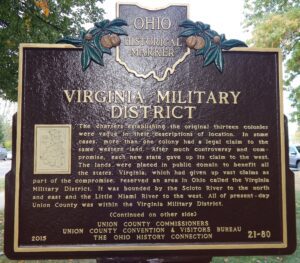
The charter establishing the original thirteen colonies were vague in their descriptions of location. In some cases, more than one colony had a legal claim to the same western land, After much controversy and compromise, each new state gave up its claim to the west. The lands were placed in public domain to benefit all the states. Virginia, which had given up vast claims as part of the compromise, reserved an area in Ohio called the Virginia Military District. It was bounded by the Scioto River to the north and east and by the Little Miami River to the west. All of present-day Union County was within the Virginia Military District. (Continued on other side)
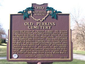
Using the power of eminent domain, the United States Government purchased 9,000 acres of land in Perkins Township, Erie County, Ohio to build the Plum Brook Ordnance Plant in 1941, displacing many families and businesses. This tract included the original Perkins cemetery, the resting-place for many of the township’s founding families who settled here in 1809 and victims of the numerous cholera epidemics of the early to mid-1800s. Though many of the earliest graves could not be located, most were re-interred here as part of the war effort on the home front during World War II.