

, OH
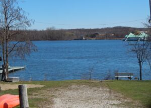
Geauga Lake, a scenic destination for visitors to northeast Ohio, was initially named “Giles Pond” after settler Sullivan Giles (1809-1880). In 1856, the predecessor of the Erie Railroad stopped at “Pond Station,” spurring the area’s growth. In the 1880s, locals established picnic grounds, a dance hall, and other facilities for those seeking a country getaway. Picnic Lake Park, later Geauga Lake Park, opened in 1887 and thereafter offered rides, a roller rink, photo gallery, billiard hall and bowling alley, among other attractions. In 1888, the Kent House hotel opened on the southeast side of the lake. In the century that followed, more attractions were added, including SeaWorld of Ohio, and the park expanded. In 2007, the melodic sounds of the carousel and the echoing screams from the “Big Dipper” roller coaster ceased when the park closed. (Continued on other side)
, OH
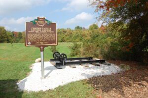
From east to west, the Chagrin Falls and Eastern Interurban Railway crossed the Muggleton Farm (now South Russell Village Park) at this location and connected the Chagrin Valley with Hiram, Garrettsville, and Middlefield. Its sister interurban, the Cleveland and Chagrin Falls Electric Railway served points west. Soon after their formation, the Everett-Moore Syndicate merged the two lines into the extensive interurban rail network, The Eastern Ohio Traction Company. The EOTC and its predecessors operated from 1899-1925, mainly moving mail, farm goods, and passengers. In 1914, the more rural line from Chagrin Falls traveling eastward became the first major interurban in the United States to cease operations. It is believed that declining use, insufficient power for the railway, and a failed line extension to Youngstown were likely factors contributing to the line’s demise.(Continued on other side)
, OH
Since it was formed in 1819, Meigs County was fostered by its location on 57 miles of the Ohio River, named by the Indians”Oyo,” meaning beautiful river. Pomeroy, the county seat, was named for Samuel Wyllys Pomeroy, an early landholder. His company, Pomeroy, Sons & Company, and his son-in-law, Valentine B. Horton (1802-1888), were influential in developing the coal, salt, and iron industries of the region. Horton pioneered the transportation of coal by river, building the world’s first coal barges and, in 1835, the first coal-fueled towboat, the Condor. Coal, salt, and iron, in addition to other local products, were shipped from Pomeroy’s 125′ x 40′ wharf to ports from Pittsburgh to Cincinnati. Excursion, passenger, shanty and showboats also visited Pomeroy’s port. Today, the Ohio River continues to be a busy waterway carrying commodities such as coal, petroleum, chemicals, steel, sand, and gravel. It is also a busy haven for recreational crafts as well as stern wheel boats.

, OH
Marion civic leaders Shauck Elah Barlow and Ida Harsh Barlow built “Waldheim,” their Colonial Revival residence, between 1903-1905. Ida Barlow, then president of the Marion Women’s Club, hosted a December 1905 meeting in her new home. Members discussed art, music, literature, and ideas for “civic improvement.” In 1909, this and other Marion clubs reorganized as the Marion County Federation of Women’s Clubs. Federation members soon organized into action: providing college loans to young women; sponsoring visiting city and later school nurses; purchasing trash receptacles; providing dental clinics for low-income residents; and funding railroad crossing safety equipment. Upon her death in 1945, Barlow bequeathed her house to the Federation as the “Women’s Club Home.” The new Federation headquarters offered meeting space for the Executive Board and the many associated clubs. (Continued on other side)
, OH
In 1837, Cincinnati merchants projected a branch canal to join the Whitewater Canal at West Harrison, Indiana, with the goal of tapping commerce from Indiana’s Whitewater Valley. The major obstacle on this route was the ridge between North Bend and Cleves, just northeast of this site. Engineer Darius Lapham designed a 1,782-foot tunnel though this barrier. Lined with brick made on site, the tunnel, 24 feet wide and 20 1/2 feet high, was the first canal tunnel in Ohio. Six workers died in its construction. The Cincinnati & Whitewater Canal opened in 1843 but was abandoned by 1856, after the main Whitewater Canal had been rendered useless by repeated flooding. The canal tunnel was subsequently used as a railroad tunnel from 1863 until 1888, illustrating the progression of transportation technology in the mid-nineteenth century.
, OH
During the 1830s, the Ohio & Erie Canal was built through Newark. The Lockmaster’s House was home to the lockmaster of Lock #9. In 1852, the first railroad locomotive steamed into Newark, signaling the beginning of the end for the canal. By 1871, the Baltimore & Ohio Railroad took over the Lockmaster’s House and the encompassing land, and built the Little Red House on the corner for the stationmaster and telegraph operator. Passenger and freight stations, a freight yard, and roundhouse were constructed nearby and served as a B&O Division Point. In 1881, the Scheidler Machine Works built a factory to manufacture steam engines and sawmills. This building now houses The Works Museum. In 1890, an electric interurban railway line connected Newark’s B&O Station to the Toledo & Ohio Central station in Granville. By 1908, the old canal was filled-in. Interurban service ended in 1929 when the city purchased buses.
, OH
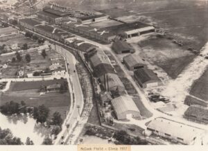
Interest in the new field of aeronautics grew dramatically when the United States entered the World War I in 1917. The army chose Dayton as the site for a research-and-development program for military aviation because of the area’s transportation links to major cities and its engineering and testing facilities. McCook Field, north of downtown between Keowee Street and the Great Miami River, was charged with researching, developing, and testing military airplanes and accessories. For nearly a decade, many advancements in aviation occurred at McCook Field. They included new aircraft, controllable-pitch propellers, bulletproof gas tanks, free-fall parachutes, and night-observation cameras. In the 1920s, larger and more-powerful aircraft overwhelmed the small field, which featured a large sign to warn pilots: “This field is small. Use it all.” In 1927, aeronautical engineering was transferred to newly-created Wright Field, now a part of Wright-Patterson Air Force Base.
, OH
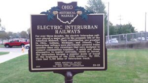
For over three decades, the electric interurban railways played a major part in the economic life of the American Midwest. Their contribution was greatest in Ohio, Indiana, Michigan and Illinois. The interurban railways were electrically-powered trains speedier than city streetcars that were designed to connect communities together. A quick and cheap alternative to regular railroads, canals or horses, the interurban became a popular mode of travel at the beginning of the 20th century. By 1915, Ohio had 2,780 miles of interurban track.