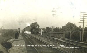
Like many nineteenth century communities in Ohio, Stryker owes its birth and early growth to the railroad industry. Stryker, named for Rome, New York, attorney and railroad executive John Stryker, was surveyed on September 19, 1853, beside the proposed Northern Indiana Railroad. For more than fifty years, “track pans” at Stryker allowed steam locomotives to take on 5,000 gallons of water while traveling at forty to fifty miles per hour, saving valuable time, “the principal enemy of railroad schedules.” On July 23, 1966, the U.S. rail speed record of 183.85 miles per hour was set through Williams County, including through Stryker. The Stryker depot was constructed in 1900 and placed on the National Register of Historic Places on August 7, 1989. (continued on other side)
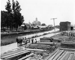
Miami & Erie Canal and Napoleon’s First Cemetery. The Miami & Erie Canal stretched approximately 250 miles from Cincinnati to Toledo. Napoleon and other towns on the Maumee River’s banks were on a slackwater section of the canal. Between 1825 and 1845, laborers constructed the canal using shovels, picks, wheelbarrows, and horse and mule-drawn carts. In Henry County, Napoleon, and elsewhere, German and Irish immigrants and area farmers did the work and were paid around 30 cents a day. As the canal brought more people and business to the area, villages such as Florida, Damascus, and Texas flourished and the county seat of Napoleon boomed. The canal and consequent growth took their tolls, however. Sickness and disease such as “ague” (malaria) and cholera spread and carried off many. Napoleon’s first cemetery was located in the vicinity of 500 East Clinton Street, near the route of the canal.
Completed in 1837, the limestone lock nine served as a catalyst for the growth of Piqua. The lock helped connect the village to Cincinnati (1837) and Toledo (1845) by way of the Miami and Erie Canal. German immigrants traveled up the canal from Cincinnati and settled within a five-block area of the lock. Industries used the lock as a source of water power and developed products as diverse as flannel, flour, and flax seed. Lock nine remained as a functioning part of the canal until its destruction during the flood of 1913.
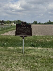
Here in 1887, frustrated locals destroyed the Six Mile Reservoir when legal efforts to close it failed. Years after any boat ran on the Wabash & Erie Canal, its water source, the 2,000-acre reservoir, became a stagnant, uncultivable breeding ground for disease-carrying mosquitos. Legislative attempts to abandon the canal and reservoir failed because manufacturers in Defiance used the waterway to float logs downstream. On the night of April 25, 1887, 200 men calling themselves “The Dynamiters” carried a banner that read, “No Compromise! The Reservoir Must Go!” and converged here, overpowered citizen guards, gouged the banks of the reservoir, dynamited the bulkhead and lock, and burned down the lockkeeper’s house. The next day, Governor Joseph B. Foraker denounced the acts of the “mob of lawless and rioting men.” (Continued on other side)
The pioneer village of Vistula is now bounded by Walnut, Champlain, Chestnut, Magnolia, and Summit streets. Established in 1833 by Benjamin F. Stickney and Edward Bissell, Vistula was merged with its rival, Port Lawrence, and in 1837 both villages were incorporated as Toledo. The Vistula Historic District, Toledo’s oldest neighborhood, was listed on the National Register of Historic Places in 1978.
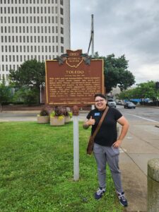
After consolidation of the villages of Fort Lawrence and Vistula, the City of Toledo was incorporated in 1837. Originally named “Toledo” in 1833, the site became part of Ohio when the “Toledo War,” a bloodless boundary conflict with Michigan, was resolved by Congress in 1836. Settlers were attracted by the commercial potential of the Maumee River, called “Miami of the Lake,” and later the Miami-Erie Canal. (Continued on other side)
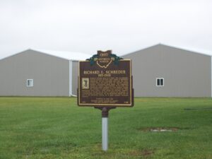
Richard E. Schreder grew up in Toledo, Ohio and graduated from the University of Toledo with a degree in Mechanical Engineering. He was a decorated navy pilot and iconic aviation figure who helped shape the American soaring movement, international glider design, and competitive soaring and piloting flight strategies. He also made high performance gliders available to a wide audience through the affordable kit production of his distinctive HP (High Performance) glider designs. These designs and Schreder’s numerous contributions to aviation and the sport of soaring are recognized as “groundbreaking and pioneering” by the Smithsonian Museum and are part of the Smithsonian National Air & Space Museum’s permanent collection. (continued on other side)
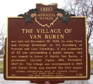
The Village of Van Buren was laid out December 28, 1833, by John Trout and George Ensminger on the boundary of Portage and Cass Townships. It was comprised of 53 lots surrounding a public square, and was named in honor of Martin Van Buren, a prominent national figure (8th President, 1837-41). The village was incorporated in 1866 and Daniel Frick was elected the first mayor.