The completion of the Wabash and Erie Canal on July 4, 1843 brought many new settlers into this region. The Wabash and Erie Canal connected with the Miami and Erie Canal at Junction. Antwerp, ideally located on the Maumee River, was seen as a perfect place in which to establish a town. That same year surveyors W. Wilshire Riley and Samuel Rice platted what would become Antwerp. Naming rights belonged to Riley and storeowner Horatio N. Curtis, who wanting a name not duplicated anywhere else in the country, named it after Antwerp, Belgium. Early pioneers subdued the massive forests that once formed the “Black Swamp” and built a thriving city. Antwerp was incorporated in 1863. (continued on other side)
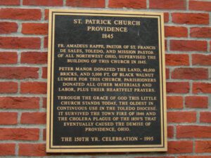
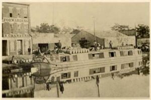
The town of Providence was born, thrived and died with the Miami & Erie Canal. It was platted in 1835 by French trader Peter Manor, swept by fire in 1846, ravaged by cholera in 1854, and finally unincorporated in 1928. Today, only the Irish builders’ St. Patrick’s Church (1845), the oldest in the Toledo Diocese; the cemetery; and Peter Manor’s house (1845) remain. The Providence Dam, built in 1838 to create a water supply for the canal’s remaining 25 miles to Toledo, was rebuilt in 1908. Peter Manor’s mill stands downstream one-half mile at Canal Lock #9, where it was built in 1822, rebuilt in 1846, and operates today as the Isaac Ludwig Historic Mill. The National Historic Register of Historic Places listed this district in 1975, the mill in 1974.
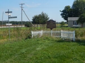
On this site, the Miami and Erie Canal, that came north from Cincinnati and the Ohio River, intersected with the Wabash and Erie Canal that came from Fort Wayne and Evansville, Indiana. From this point, which became the town of Junction, the canals proceeded as one to Defiance, Toledo, and Lake Erie. From the 1830s to the 1870s, the canals played a key role in the settling of Paulding County, an area that was once a part of the Great Black Swamp. They held the promise of easier and quicker passenger transportation and commodity shipping and Junction became a landmark for fugitive slaves escaping to Canada. Once a thriving and growing community, the village of Junction became a forgotten historical note with the passing of the canal era and the coming of the railroads. Today, the Buckeye Trail and North County Trail follow the canal path through Paulding County.
At Middletown, Ohio, on July 21, 1825, ground was first broken for the Miami-Erie Canal, which eventually linked Cincinnati and Toledo. The canal created much change in the region, including increased population and commercial, political, and industrial growth. Products grown and manufactured in this previously isolated area now had access to world markets. Prosperity reigned until the 1860s when railroad competition caused a slow decline in canal transportation. The canal was officially closed on November 2, 1929, again, as it had started, in Middletown. The canal bed was converted into a modern highway, known as Verity Parkway, which runs parallel to this park.
SE of intersection of Paige Street & N Lynn Street
Bryan
, OH
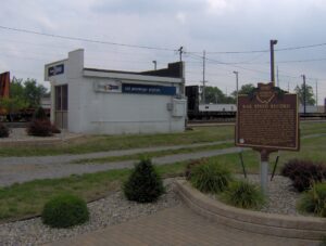
In 1966 the New York Central Railroad Company (A.E. Perlman, President) proposed a test of existing rail passenger equipment to determine the feasibility of operating high-speed passenger service between cities up to 300 miles apart. The site chosen for the test was near Bryan, Ohio on the longest multiple track straight railroad line in the world. This sixty-seven mile straight trackage from Toledo, Ohio to Butler, Indiana was originally constructed by the Northern Indiana Railroad Company of Ohio incorporated March 3, 1851. On July 23, 1966 the New York Central Technical Research Department ran their Budd RDC-3 passenger car number M-497 fully instrumented for stress analysis, and propelled by two roof-mounted jet aircraft engines. The speed of 183.85 miles per hour was attained, the highest recorded on a railroad in North America at that time and to this day.
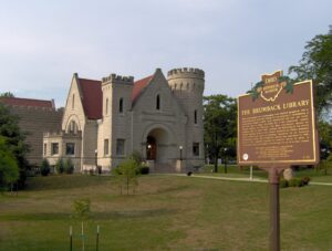
When local banker and businessman John Sanford Brumback left a large bequest to Van Wert County for the purpose of establishing a countywide library in 1897, such institutions did not yet exist, and Ohio had no legal provision for a tax-supported county library system. In response, the Ohio Legislature passed an enabling law in April 1898, marking the beginning of the county library system in the United States. Designed by Toledo architect David L. Stine and built of Bedford limestone in an eclectic Romanesque style, the Brumback Library was dedicated in 1901. Added to the National Register of Historic Places in 1979, it continues to serve as a center of knowledge for all of Van Wert County.
With the signing of the Treaty of Paris in 1783, England lost the American Revolution and ceded to its former colonies land from the Atlantic Ocean to the Mississippi River. By this time, pioneer settlers had reached the eastern bank of the Ohio River, but the Ohio Country, located west and north of the river, was still considered Indian Territory. The Indian tribes desperately defended their hold on this land. On August 20, 1794, United States forces led by Major General Anthony Wayne defeated an Indian alliance at the Battle of Fallen Timbers fought near modern-day Toledo. One year later, on August 3, 1795, the largest assemblage of northwestern Indian representatives at a peace settlement signed the Treaty of Greene Ville, which effectively ceded all land south of the Greene Ville Treaty line to the Americans. The Fort Laurens site was a reference point in the Treaty line. The Ohio Country was then rapidly settled, and in 1808, Tuscarawas County was organized.
After the War of 1812, the United States Congress proposed two million acres of military bounty land for the Michigan Territory. To survey the land, the meridian had to first be established. U.S. Surveyor General Edward Tiffin created the meridian based on the western line of the Treaty of Detroit (1807). He contracted with Deputy Surveyor Benjamin Hough in April 1815 to begin the survey for $3 per mile. Taking a reading from Polaris (the North Star), Hough, Alexander Holmes, and 11 crew members surveyed the line due north from Fort Defiance. The difficult terrain they encountered temporarily halted all surveys in the territory and ultimately led to the bounty land being transferred to the Illinois and Missouri Territories.