

, OH
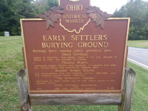
Resting here among other pioneers are: Obed Denham, native of Plainfield, New Jersey, donor of this plot, founder of Bethel in 1798, and pioneer abolitionist; Thomas Morris, antislavery leader, veteran state legislator, U.S. senator 1833-1839, and Liberty Party vice presidential nominee 1844; Reader Wright Clarke, U.S. representative from the Clermont District 1865-1869, and U.S. Treasury second auditor 1869-1870; “The Unknown Hunter”; befriended by Obed Denham and the first person buried in this hallowed ground.
, OH
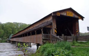
Replacing an earlier bridge that was carried away in a spring flood, the Harpersfield Covered Bridge was built in 1868 and spans the Grand River, a state-designated wild, and scenic river. This bridge, which currently carries County Road #154 (Harpersfield Road), is a two-span wooden Howe truss bridge, with center pier. The great flood of 1913 washed away the northern approach and it was at this time that the additional 140 foot steel truss was added. Extensive rehabilitation in 1992 included strengthening the lower chords, lowering and replacing the floor, and adding a cantilevered walkway. The 228-foot-long Harpersfield Bridge is the longest covered bridge in Ohio and is on the National Register of Historic Places.
, OH
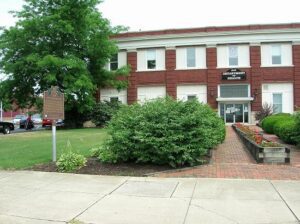
In 1910, the Ohio Electric Railway Company opened this terminal, formerly the Interurban Building, which served interurban passengers until 1937. Along with offices, it contained space for express and baggage handling, ticket windows, a newsstand, a lunch counter, and waiting rooms. Three tracks were laid at the rear of the building. At its peak, Ohio Electric radiated from Lima to Springfield, Toledo (via Ottawa), Defiance, and Fort Wayne. Its competitor, The Western Ohio Railway (“Lima Route”) connected Dayton and Toledo (via Findlay). The interurban network in and around Lima led to the creation of suburbs, linked industrial and residential areas, and promoted the creation of amusement parks and small lake resorts. With decreased passenger traffic due in part to personal automobiles and the Great Depression, the interurban and street railway era in Lima ended in 1939, 52 years after it had begun as Ohio’s first successful electric streetcar system.
, OH
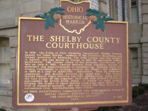
In 1819, the State of Ohio formally recognized Shelby County, named for Isaac Shelby, veteran of the American Revolution and former governor of Kentucky. The first county seat was located in Hardin, but was moved to Sidney in 1820 to centralize county government. The corner stone of the present courthouse was laid on July 4, 1881. George Maetzel from Columbus served as architect and superintendent of construction. Modeled after the county courthouse in Licking County, the project was completed in 1883 at a cost of $200,000. Materials, such as limestone, sandstone, and marble arrived by canal boat. The French Second Empire style building has four symmetrical sides facing the four points of the compass, each side with pillared porticoes approached by broad stone steps. A figure of Lady Justice holding the scales of equal justice surmounts each facade. The roof is classical mansard, and the center170-foot tower is of galvanized iron, encompassing four clocks.
, OH
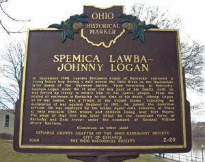
In September 1786, Captain Benjamin Logan of Kentucky captured a young Indian boy during a raid across the Ohio River on the Machachac tribe towns of the Shawnee nation. Upon returning to Kentucky, Captain Logan made the 14 year old boy part of his family until he was forced by treaty to return him to his native people. From the period of residence in Kentucky to the time of his death, Johnny Logan, as he was named, was a friend of the United States. Following the declaration of war against England in 1812, he joined the American service. He was employed by the Indian Agent John Johnston at Piqua to help evacuate Ohio women and children living near Fort Wayne. The siege of that fort was later lifted by the combined force of Kentucky and Ohio troops under the command of General William Henry Harrison. [continued on other side]
, OH
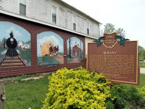
The village of Albany was established in 1838 as a market center for the surrounding agricultural area, which saw its first white settlement in the early years of the nineteenth century. Education was always a major concern of Albany’s citizens. Since public schooling was minimal, private academies provided the community various levels of education from the 1840s to the 1880s. Anti-slavery sentiment also was strong in Albany, and many of its citizens participated in the “Underground Railroad.” Because of educational opportunities and sympathetic white neighbors, free African-Americans came to Albany, but most had moved away by the 1930s. After World War Two, the village lost its status as a center for commerce and business.
, OH
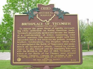
The great Native American Shawnee leader, Tecumseh, was born on the bank of a large spring at this site in 1768, at the very instant that a great meteor seared across the skies. The birth occurred while his parents, Shawnee war chief, Pucksinwah, and his wife, Methotasa, were en route from their village of Kispoko Town, on the Scioto River, to a major tribal council at the Shawnee tribal capital village of Chalahgawth (Chillicothe – now Oldtown), which was located “two arrow flights” northwest of this site. Though prohibited by tribal tradition from becoming chief of the Shawnees, Tecumseh rose to become one of the greatest warriors, orators, and military strategists of any tribe in America.
, OH
The W. Pearl King Prairie Savanna is a mostly undisturbed remnant of the once expansive Darby Plains Prairies. Prior to European settlement more than two centuries ago, the Darby Plains covered an area of more than 380 square miles west of Columbus. These prairies were an eastward extension of the Great Plains Prairie that Ohio State Professor Edgar Transeau termed the Prairie Peninsula in 1935. The W. Pearl King Prairie Savanna is a 20-acre vestige of a once large and varied habitat of native tallgrass prairie and oak groves. The prairie contains bur oaks, one of Ohio’s largest stands of prairie dropseed grass, and several other native prairie plants. Named for a former landowner, William Pearl King (1891-1960), the site has been owned and managed by Columbus and Franklin County Metro Parks since 2006.