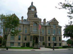
Hancock County was organized March, 1828, court being held in a log schoolhouse. In 1833, a frame courthouse was built. It served until 1840, when a brick structure went up on this site. During the oil and gas boom of the 1880’s, the present courthouse was erected at a cost of $305,272, and dedicated Oct. 27, 1888.
This historic village was a hub for early Ohio industry and travel. The natural geography of the area provided ideal conditions for the establishment of a variety of mills. Col. Robert Patterson, an ancestor of the founder of National Cash Register in Dayton, John Patterson, chose Clifton for the site of a woolen mill, which furnished material for the American army during the War of 1812. Davis Mill, established in 1802 and in operation today as Clifton Mill, produced meal and flour for Civil War troops. A major stop on the stagecoach trail, “The Accommodation Line,” which ran from Springfield to Cincinnati from 1827 to 1840, the village bustled with the commotion of travelers. The once flourishing industry of Clifton faded as railroad traffic bypassed the village and manufacturers left the area.
Two Deputy U.S. General Land Office Surveyors traversed Goll Woods: Benjamin Hough in 1815 and Captain James Riley in 1821. Hough (1772-1819) established the Michigan Meridian in 1815 and was county and state office holder in Ohio. Riley’s life was more tumultuous. Riley (1777-1840) captained the merchant ship Commerce, which wrecked off the Saharan coast in 1815. Riley and crew were enslaved for four months until ransomed by British diplomat William Willshire. In 1817, Riley published a famous account of his time in North Africa, and, in 1819, was appointed a surveyor by Surveyor General Edward Tiffin. Moving to Northwest Ohio, Riley named the village he founded in 1822, Willshire, for his deliverer. Riley returned to New York in 1826 and to the sea, where he died. Riley’s book went through more than twenty editions by 1860 and Abraham Lincoln credited the account as one that influenced him deeply.
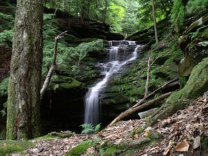
Hemlock Falls is located nearby. Two small streams cascade down the face of the massive sandstone cliff in the shade of tall hemlock trees. One of the falls drops about 60 feet and the other about 100 feet. The rock is Black Hand Sandstone deposited in the deltas along the great salt-water sea during the Mississippian Period about 350 million years ago. The cliffs were created later and were produced by erosion along the side of the valley of the ancient pre-glacial Groveport River. One large slump block, which has separated from the rock wall by weathering, may be the largest in Ohio. Plants more typical of the Appalachian Plateau and rare to Richland County can be found in this area. The ecosystem is typical of that found at the past edge of a glacier.
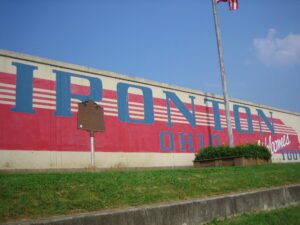
In 1849, the city of Ironton was founded by local ironmasters, railroaders, and financiers associated with the Ohio Iron and Coal Company. They saw the city as a manufacturing and shipping point for their products. As a young industrial city, Ironton prospered when river transportation facilitated the development and export of Lawrence County’s natural resources and manufactured items. The Iron Railroad Company was also established to transport pig iron and manufactured goods from nearby towns to Ironton, to awaiting steamboats on the Ohio River. Steamboats, in the form of towboats, packet boats, and showboats, traveled the river providing the city with goods, services, and entertainment. The Ironton wharf and boat landing once served the community as a gathering place to greet incoming passengers, receive mail, and hear the latest news.
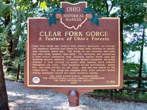
Clear Fork Gorge was formed when glacial meltwater cut through the sandstone bedrock that forms its steep walls fourteen to twenty-four thousand years ago. The gorge is one thousand feet wide and over three hundred feet deep. Its seclusion has preserved a rare forest community that includes native white pine and towering eastern hemlock. A National Natural Landmark, the gorge displays a wide variety of other tree species more common throughout the state, with sycamore on the bottomlands, beech, ash, and tulip farther up the slopes, and oak and maple on the ridges above. The gorge has changed little since pioneer legend Johnny Appleseed tended his apple orchards nearby.
Due to what is known as the Sharon Conglomerate or pebbly sandstone, these ledges have played an important role in the daily life of local residents and the economy. The porousness of this rock, which underlies much of Geauga County, supplies most of the county’s drinking water. Thompson Ledges also provided building stone with stone cutters working in quarries turning out doorsteps, watering troughs, gateposts, culverts, and bridges from mid-1800 to 1911 for use in Thompson, Geauga County and occasionally beyond. After 1900, cement became the preferred building material, but still used silica pebbles from the Ledges for gravel and cement. The Ledges have an unusual ecosystem containing several distinctive forests. A chestnut oak forest is pervasive on the top while a northern hemlock forest exists in the exposed creaks and crevices of the upper rim and ledges.
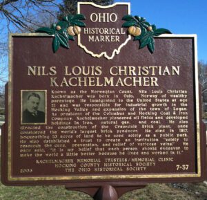
Known as the Norwegian Count, Nils Louis Christian Kachelmacher was born in Oslo, Norway of wealthy parentage. He immigrated to the United States at age 21 and was responsible for industrial growth in the Hocking Valley and expansion of the town of Logan. As president of the Columbus and Hocking Coal & Iron Company, Kachelmacher pioneered oil fields and developed holdings in iron, natural gas, and coal. He also directed the construction of the Greendale Brick plant, once considered the world’s largest brick producer. He died in 1917, bequeathing 10 acres of land to be used solely as a public park. He also established a trust to create an institution “solely to research the cure, prevention, and relief of varicose veins.” He once said, “It is my belief that each person should endeavor to make the world a little better because he lived and worked in it.”