You are standing on the famous portage, carrying-place between the Cuyahoga and Tuscarawas rivers. The two streams and the portage across the watershed formed an early route between Lake Erie and the Ohio River. First the Indians, then French and English traders and trappers, and finally American settlers and travelers carried their canoes and packs across this narrow strip of land in passing, by way of the rivers, between northern and southern Ohio. The portage was a part of the defined boundaries in the treaties with the Indians made at Fort McIntosh (1785), Fort Harmar (1789), and Green Ville (1795). Use of the portage was discontinued in 1827 when the Ohio and Erie Canal was built along the old trail. Today, modern Akron streets–Portage Path and Manchester Road–follow the approximate route of the original portage.
Oldest Religious Congregation in north-central Ohio. First Methodist Sermon preached at the “spring” in 1809 by Rev. James Copus. Services then conducted in blockhouse, 1811; in first court house, 1813; at church home of Dr. William B. James, 1814; first church building located N.W. corner Park Avenue East and Adams, 1820; present site in 1870. All land donated by General James Hedges, a distinguished member.
As a member of the Connecticut Land Company, Judge Samuel Hinckley of North Hampton, Massachusetts purchased township 4N Range 13W of the Western Reserve in 1795 for a sum equivalent to 23 cents an acre. The township remained unsettled until Abraham Freeze was commissioned by Judge Hinckley in 1819 to survey the township into 100 plots of 160 acres each. In return for having the township, founded in 1825, named “Hinckley,” the judge gave land for two burying grounds and one-half acre for a public square. In 1919, upon the 101st anniversary of the “Great Hinckley Hunt,” where men from surrounding counties gathered on Christmas Eve to rid the township of wild animals, Judge Amos Webber spoke for the deceased Judge Hinckley: “When I last saw this country, it was a howling wilderness – by industry and frugality you and your ancestors have made these ever lasting hills and pleasant valleys blossom as the rose.”
The Northwest Ordinance of 1787 defined the boundary of the northern and southern tier of states to be carved out of the Northwest Territory, as a line drawn east from the southernmost tip of Lake Michigan until it intersects Lake Erie. Controversy over the exact location of that line led to the 1834-1837 boundary dispute between the State of Ohio and Michigan Territory. Passions ran high as everyone on both sides of the boundary knew that a great port city (Toledo) would emerge in the disputed territory. President Andrew Jackson settled the dispute in 1836 when he signed an act that recognized the current border between Ohio and Michigan, giving Michigan 9,000 square miles of Upper Peninsula land and awarding the disputed strip of approximately 470 square miles to Ohio. Michigan then joined the nation as a state the following year.
Intersection of Mt. Vernon Avenue and LWR Gamiber Road.
Mount Vernon
, OH
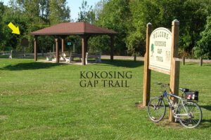
Named for the Native Americans who first dwelled here along both sides of the Kokosing River, the Little Indian Fields is adjacent to the site of the first white settlement of Knox County. Early white inhabitants of this land were Andrew and Catherine Craig and Benjamin and John Butler. John “Appleseed” Chapman planted an apple orchard near here at the confluence of the Kokosing River and Centre Run and in 1809 bought two lots in Mount Vernon. In 1808 the Ohio Legislature created Knox County and later designated Mount Vernon as the county seat.
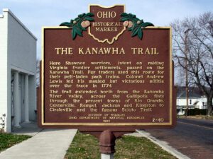
Plunging herds of buffalo seeking salt licks and grazing lands wore trails through the Ohio Country when it was an Indian no-man’s land. Later, Indians found the same trails suitable for their needs. The tawny paths were highways as well as highest ways. Indians found ridges and summits superior to valleys for trails because they were drier, windswept of snow, never clogged by flood debris and safer.
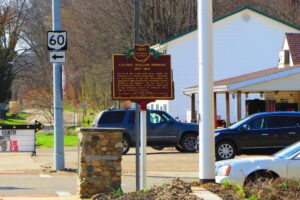
Colonel William Simmons (1757-1823) served in the Continental Army under the command of General Washington. Appointed as Accountant of the War Department by Washington and served under Presidents Adams, Jefferson and Madison. For his services in the Continental Army, received a land grant in the northeast section of Jefferson Township in Coshocton County.
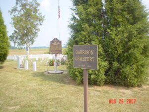
Descendants of Lemuel Garrison Sr., a Revolutionary War soldier, were among the first Europeans to own and settle land at Garrison Corner (intersection of State Route 123 and Shawnee Trace) . Garrison Cemetery burials took place from ca. 1837 to 1936. The cemetery has 327 lots. Eighty-six burials are documented including veterans John J. Garrsion, Benjamin Garritson, James Knicely, Nicodemus Rude, and William Rude. (continued on other side)