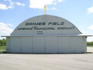
Raised in an Ohio orphanage, Warren G. Grimes (1898-1975) ran away after finishing the ninth grade and at age 16 went to work for the Ford Motor Company in Detroit. He later became a partner in an electrical business where he was instrumental in designing and developing the first lights for the Ford Tri-Motor airplane. In 1930 Grimes moved to Urbana and founded a small lighting fixture plant, Grimes Manufacturing. The inventor of the familiar red, green, and white navigation lights found on the wing tips and tails of aircraft, Grimes, known as the “Father of the Aircraft Lighting Industry,” also developed other aircraft fixtures, including landing, instrumental, and interior lights. Every American-made airplane flown during World War II was equipped with Grimes lights. Grimes served as mayor of Urbana and chairman of the State of Ohio Aviation Board.
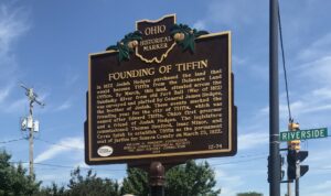
In 1822 Josiah Hedges purchased the land that would become Tiffin from the Delaware Land Office. By March, this land, situated across the Sandusky River from old Fort Ball (War of 1812) was surveyed and platted by General James Hedges, the brother of Josiah. These events marked the founding year for the city of Tiffin, which was named after Edward Tiffin, Ohio’s first governor and a friend of Josiah Hedges. The legislature commissioned Thomas Henford, Isaac Minor and Cyrus Spink to establish Tiffin as the permanent seat of justice for Seneca County on March 25, 1822.
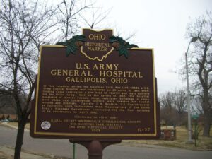
At this location, during the American Civil War (1861-1865), a U.S. Army General Hospital was constructed on 29 acres of land overlooking Camp Carrington, a site used to recruit and train soldiers for the Union Army. Built in the spring of 1862, this hospital consisted of several wooden, ridge-ventilated buildings in which both Union and Confederate soldiers were treated for combat wounds and illnesses. Captain C.M. Moulton, U.S. Quartermaster at Gallipolis, upon instructions from Headquarters of the Union Army’s Mountain Department, contracted for the first building to be constructed in April 1862. (continued on other side)
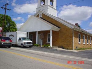
The First Presbyterian Church of West Union, built in 1810, is known as the “Church of the Governors.” Although the date is uncertain, the congregation was organized circa 1800 on Thomas Kirker’s land on Eagle Creek, about three miles from West Union. Kirker, Ohio’s second governor, was influential in organizing the congregation and raising funds for the construction of the building. Stonemason, Thomas Metcalfe, Kentucky governor from 1828-1832, was awarded the contract to build the walls for $250.00; the total construction cost was $500.00. The first three regular ministers – William Williamson, Dyer Burgess, and John P. Van Dyke – all held strong anti-slavery sentiment that was felt throughout the congregation. During the Civil War, soldiers of the 70th Ohio Volunteer Infantry, a regiment of recruits from Adams County and eastern Brown County, were said to have been temporarily quartered in the church before leaving West Union in 1861.
Aurora’s first church was established on December 31, 1809 under the guidance of the Connecticut Missionary Society. The congregation called the Rev. John Seward of Granby, Massachusetts to be the first minister in 1812. Built on land donated by Samuel Forward and dedicated in 1824, the original brick church was replaced by a wood-frame building in 1872. The First Congregational Church and the Aurora Disciples of Christ formed an association called the Federated Church in Aurora in 1913. These three entities merged to form The Church in Aurora in 1933, serving the community as more than a landmark.
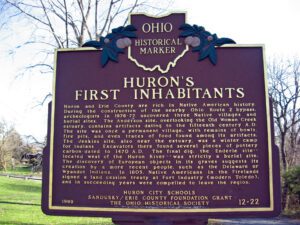
Huron and Erie County are rich in Native American history. During the construction of the nearby Ohio Route 2 bypass, archeologists in 1976-77 uncovered three Native villages and burial sites. The Anderson site, overlooking the Old Woman Creek estuary, contains artifacts dating to the fifteenth century A.D. The site was once a permanent village, with remains of bowls, fire pits, and even traces of food found among its artifacts. The Jenkins site, also near the estuary, was a winter camp for Indians. Excavators there found several pieces of pottery carbon-dated to 1470 A.D. The final dig, the Enderle site — located west of the Huron River — was strictly a burial site. The discovery of European objects in its graves suggests its creation by a more recent people, such as the Delaware or Wyandot Indians. In 1805, Native Americans in the Firelands signed a land cession treaty at Fort Industry (modern Toledo), and in succeeding years were compelled to leave the region.
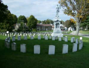
Envisioned as a rural cemetery with careful attention to landscaping design and symmetrical lots, the Riverview Cemetery was established in 1883 on forty acres of land. The chapel was a gift to Riverview from the Grand Army of the Republic, mostly Civil War veterans, and was dedicated on Memorial Day 1899. Plaques inside the chapel list 702 men from Ohio, Pennsylvania, and West Virginia who served in the Civil War, including 311 who are memorialized or buried at Riverview. There are also plaques listing soldiers killed in World Wars I and II, Korea, and Vietnam. The rich history of East Liverpool and Columbiana County is documented in the burials at Riverview Cemetery.
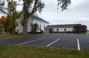
The comingling of faiths in an area settled predominantly by Quakers helps explain the origins of Jonah’s Run Baptist Church. Ministered to by a Baptist preacher, the children and neighbors of Daniel Collett (1752-1835), an Episcopalian and private in the Revolutionary War, and his wife Mary Haines Collett (1753-1826), a Quaker from Virginia, became Baptists and started the church in 1838. Levi Lukens (1767-1860), a Quaker from Pennsylvania by way of Virginia, purchased the land where the church stands in 1812 and sold it in 1839 to a founder of the congregation. Like local Quaker meetinghouses, the church had separate entrances for men and women and a partition between the two that divided the sanctuary. The congregation’s sons and daughters lived their faith. Howard McCune (1852-1923) was the Clinton Baptist Association’s moderator and president of the Ohio Baptist Convention’s state board. Anne Cossum (1894-1977) was a missionary in China from 1920-1927.