

, OH
You are standing on the famous portage, carrying-place between the Cuyahoga and Tuscarawas rivers. The two streams and the portage across the watershed formed an early route between Lake Erie and the Ohio River. First the Indians, then French and English traders and trappers, and finally American settlers and travelers carried their canoes and packs across this narrow strip of land in passing, by way of the rivers, between northern and southern Ohio. The portage was a part of the defined boundaries in the treaties with the Indians made at Fort McIntosh (1785), Fort Harmar (1789), and Green Ville (1795). Use of the portage was discontinued in 1827 when the Ohio and Erie Canal was built along the old trail. Today, modern Akron streets–Portage Path and Manchester Road–follow the approximate route of the original portage.
, OH
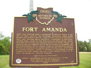
After Gen. William Hull’s surrender at Detroit early in the War of 1812, most of the Michigan Territory came under British and Indian control. To prevent a possible invasion of Ohio, Gen. William Henry Harrison, commander of the Northwestern Army, called up the Kentucky and Ohio militia. Rather than moving troops and supplies across the Black Swamp, he chose to use the Auglaize and St. Marys rivers. In November 1812 Harrison ordered Lt. Col. Robert Pogue of the Kentucky Mounted Militia to construct a supply depot at this site, previously an Ottawa village. Pogue, a veteran of the Battle of Fallen Timbers in 1794, named the post Fort Amanda after his 12-year-old daughter, Hannah Amanda. (continued on other side)
, OH
The landscape of northwest Ohio was formed by melting ice and the glacial lakes left behind in its wake. Because of the low gradient (3 feet fall per mile) to the northeast, the flat lacustrine plain evolved into a large swamp. A massive swamp forest with huge hardwoods, broken only sporadically with intermittent wet prairies and savannahs, dominated the landscape. Both prehistoric and historic Indians farmed the flood plains of the Maumee River and its tributaries: Auglaize, Tiffin, and Blanchard rivers. (continued on other side)
, OH
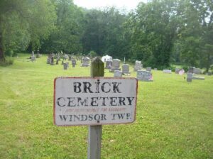
The Windsor Township Baptist Association was organized January 11, 1818 by Elder William Davis with 35 members who met in homes, barns and schoolhouses. At the death of the six-year-old granddaughter of Samuel and Tabitha Davis Henery, this plot by the river was laid out of a church yard and deeded by John Henery in 1837. In 1838 a brick church was built at the cost of $1,000. It served this community until the road and church were destroyed by the flood of 1913. More than 50 men from this area served in the Civil War. Twenty-six War of 1812 veterans are buried here as well as William Davis, veteran of the American Revolution; Obadiah Brokaw, founder of Big Bottom State Memorial; and Captain Isaac Newton Hook, river pilot at the age of ten and U.S. master of inland navigation, 1860-1873, who ran supplies on the Tennessee and Cumberland rivers for the Union Army. At Captain Hook’s death in 1906, the steamers Valley Gem, Zanesville, and Sonoma from Marietta in his honor landed passengers at the church here for his funeral, “largest ever held in the Muskingum Valley.” “The Lord and the River giveth and then taketh away.”
, OH
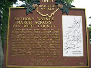
To the right is the route taken by the U.S. Legion under Major General Anthony Wayne as it marched across what would become Van Wert County. The army of 2,800 men camped west of this marker near the present cemetery on the night of August 4, 1794. Wayne’s orders were to subdue Native American tribes and his destination was a major village at the junction of the Auglaize and Maumee Rivers (now Defiance). Finding it abandoned, Wayne marched down the Maumee River and was attacked by a force of Indians on August 20. Wayne’s victory at the Battle of Fallen Timbers ended the Indian Wars of the 1790s. The Treaty of Greene Ville, signed by Wayne and the representatives of twelve tribes, opened much of Ohio to American settlement. Side one includes a map on the right hand side of the marker showing the route of Wayne’s army through the eastern third of Van Wert County.
, OH
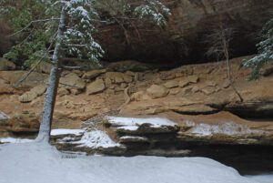
This recess cave was named for the “old man” Richard Rowe, a recluse who made the cave his home in the 1800s and is a part of scenic Hocking Hills State Park. Hocking comes from the Wyandot Indian word “hockinghocking,” referring to the Hocking River’s bottle-shaped gorge near Lancaster. Streams and percolating groundwater carved the hollows and caves in this area from layers of sandstone bedrock that vary in hardness. The hollow’s moist, cool climate preserves more typically northern tree species such as eastern hemlock trees and Canada yew, which have persisted since the glaciers retreated 15,000 years ago.
, OH
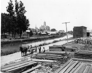
Miami & Erie Canal and Napoleon’s First Cemetery. The Miami & Erie Canal stretched approximately 250 miles from Cincinnati to Toledo. Napoleon and other towns on the Maumee River’s banks were on a slackwater section of the canal. Between 1825 and 1845, laborers constructed the canal using shovels, picks, wheelbarrows, and horse and mule-drawn carts. In Henry County, Napoleon, and elsewhere, German and Irish immigrants and area farmers did the work and were paid around 30 cents a day. As the canal brought more people and business to the area, villages such as Florida, Damascus, and Texas flourished and the county seat of Napoleon boomed. The canal and consequent growth took their tolls, however. Sickness and disease such as “ague” (malaria) and cholera spread and carried off many. Napoleon’s first cemetery was located in the vicinity of 500 East Clinton Street, near the route of the canal.
, OH
Evansport is named after brothers Amos and Albert G. Evans who, with Jacob Coy, had the village surveyed next to the Tiffin River on December 14, 1835. The “port” suffix in Evansport’s name reflects the river’s significance as a transportation thoroughfare. Evansport’s early growth was spurred by its mills powered by the Tiffin River. The mills provided settlers with lumber for buildings and supplied flour and cornmeal for sustenance and commerce. Settlers who poured into Williams County’s northern townships in the 1830s agitated debate about moving the county seat to a more centralized location. Evansport was platted as a possible site for the county seat. The Williams County seat was moved to Bryan in 1840 and in 1845 Defiance County was created, leaving Evansport on the Williams-Defiance county line.