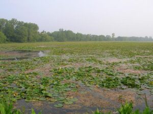
Nearly 90% of Ohio’s wetlands have been drained or filled. Kettle holes, sphagnum peat bogs, prairies, and oak openings are still found in a few glaciated areas in the northern half of the state. Coastal areas along Lake Erie and bottomlands along Ohio’s rivers and streams preserve the remaining wetlands. Once a commercial fur farm, Spring Valley Wildlife Area exhibits the abundance of waterfowl and other wildlife common in wetlands, brushlands, and upland forest areas. More than 230 species of birds have been recorded here.
The Muskingum River forms at the confluence of the Tuscarawas and Walhoning rivers at Roscoe Village and flows south approximately 100 miles to the Ohio River at Marietta. During the first half of the nineteenth century, fugitive slaves from Virginia crossed the Ohio River and followed the Underground Railroad lines north toward Canada. Four Underground Railroad lines converged in Roscoe Village on the Muskingum River. The first followed the river north out of Marietta through Rainbow and Waterford. An Ohio River crossing at Belpre connected runaways with the Muskingum River at Putnam in Muskingum County. Two others came from the west through Granville in Licking County and New Concord in Muskingum County. From Roscoe Village, fugitive slaves sometimes traveled from station to station along the Ohio-Erie Canal that was completed in 1825. The canal ended at Lake Erie where the runaway slaves were assisted in crossing into Canada.
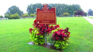
In 1791, Captain Jonathan Devol, upon a proposal from Griffin Greene, designed and built a floating grain mill, which was erected on two boats and anchored within several yards of the Ohio River shore near this marker. Oak planks fastened the boats together and formed a deck, upon which sat a frame building that enclosed the mill’s running gears and millstones. The mill’s position in a rapid portion of the river and its proximity to Farmer’s Castle, a fortification of thirteen blockhouses, built by local farmers at the beginning of the Indian Wars, shielded it from Indian raids. The river’s current revolved the wheel of the mill, and depending on the strength of the current, between twenty-five and fifty bushels of grain were processed in twenty-four hours. Devol’s floating mill replaced the hand mill, which had become too laborious to operate. The mill supplied meal to the garrison at Farmer’s Castle and other settlers along the Ohio River for a distance of nearly thirty miles.
Thirty-thousand years ago, the streams and rivers in this area flowed north. A ridge extended across what is today the Muskingum-Morgan County line about seven miles south of the Philo Lock. When the Wisconsin Glacier moved down from Canada 25,000 years ago, the glacier blocked the north flowing streams. A large lake formed in Muskingum County. Eventually the water spilled over the ridge and flowed to the Ohio River, carving the Muskingum River Valley. When the glaciers retreated, the drainage divide moved north to an east-west line 30 to 50 miles south of Lake Erie. The Tuscarawas, Walhonding, Scioto, Muskingum and other area rivers and streams have continued to flow south ever since.
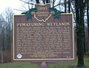
The advancing and retreating mile-high glacial sheet of ice and snow shaped the countryside around this area. As the last of the ice masses melted, a great swamp developed, punctuated by towering white pines, bogs, and wetlands, fed by the Shenango and Beaver rivers. Abundant wildlife drew prehistoric and later historic Native Americans into the area where they lived and hunted for thousands of years. Indian legend has it that the name Pymatuning means “The Crooked-Mouthed Man’s Dwelling Place,” referring to a Native American chief who once resided in the area. European trappers came to these swamp lands in the 1700s in search of beaver and other fur-bearing animals. Pioneer farmers and lumbermen came to the area after 1800, but settlement in the swamp was slow and difficult. Eventually much of the area was cultivated in onions and other root crops. (continued on other side)
Colonel Ebenezer Zane played a major role in the development of Ohio, a role that helped place it on the path to statehood. A veteran of the Revolutionary War and experienced road builder, he received permission from Congress in 1796 to build a road into the Northwest Territory, which would be called Zane’s Trace. In exchange for his work, Zane received land grants where the trace would cross the Muskingum, Hocking, and Scioto rivers. The trace began in Wheeling, West Virginia (then Virginia) and ended at Limestone, Kentucky (present-day Maysville) on the Ohio River. Opening in 1797, it brought settlement into Ohio, including Lancaster. Its route crossed the playground area of East Elementary from the northeast corner of today’s playground to the southwest corner, lot #18, East Addition, as recorded on an 1897 map of Lancaster.
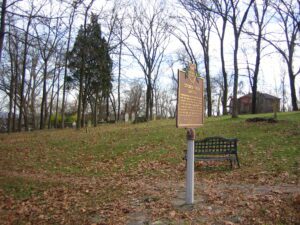
Originally belonging to the William Henry Harrison family, this cemetery was known as “The Pasture Graveyard” until the Civil War era. It became the final resting place of many members of the Harrison and Symmes families as well as other early settlers to the North Bend area. It was in use until 1884 when Maple Grove Cemetery opened as the official township cemetery.
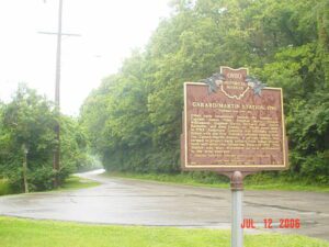
Site of the first fortified settlement in Anderson Township and one of the first in the Virginia Military District. John Garard and Joseph Martin were the founders of this Station, who, with Elias Garard, Joseph Frazee, and others, came by two flatboats with families and livestock from Garards Fort, Pennsylvania, via the Ohio and Little Miami rivers. They landed here on December 23, 1790, and proceeded to erect the fortification.(Continued on other side)