

, OH
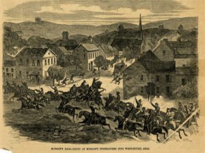
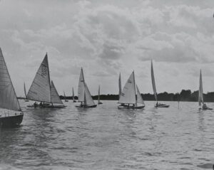
As Morgan’s Raiders rode eastward across southern Ohio during the third week of July 1863, the scattered defensive forces pursuing him consolidated and drew closer. Four regiments under Brigadier General Eliakim P. Scammon (including the 23rd Ohio, containing future U.S. Presidents Rutherford B. Hayes and William McKinley Jr.) arrived here by steamboat on July 18, preventing Morgan from entering Pomeroy. Brigadier General Henry Moses Judah’s division also arrived in Pomeroy on July 18, immediately marching east following Morgan. Following Morgan’s defeat at Buffington Island on July 19, both Judah and Brigadier General Edward H. Hobson returned to Pomeroy and headquartered at the Grand Dilcher Hotel. Of the approximately 900 Confederate prisoners captured in Meigs County, 227 were held here at the courthouse before being sent downriver to Cincinnati.
, OH
Mahoning County was created in 1846 by combining townships from southern Trumbull and northern Columbiana counties. Canfield engaged in competition with several surrounding communities for the new county seat, and its success was attributed to its central location along with the state and local political influence of Judge Eben Newton and Elisha Whittlesey, Esq., Comptroller of the United States Treasury from 1849-1857. To become the county seat, the State of Ohio required “a suitable lot and $5,000 toward public buildings” Judge Newton donated the land and spearheaded the subscription of the state required bond. Once attained, construction progressed rapidly on the Classical Revival style courthouse, completed in June 1848. The Italianate style West wing was added in 1862, but its government status was challenged when in the early 1870s, Youngstown, by now a city, resumed its earlier challenge for the county seat. (continued on other side)
, OH
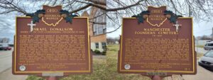
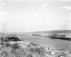
In May 1800, Congress passed an act dividing the Northwest Territory, with the western division becoming Indiana Territory and the eastern called the Territory of the United States northwest of the Ohio River. Two years later, thirty-five delegates from the nine counties of the latter division convened in Chillicothe to draw up the constitution for the new state of Ohio, which became a state in 1803. Israel Donalson was the last survivor of the convention dying in 1860 at the age of 93. This frontiersman served Manchester as a surveyor, schoolteacher, postmaster, and judge in the first court. In 1791, one month after his arrival here at Massie’s Station, Donalson was captured by Native Americans. His memoir is a colorful account of his capture and escape. Donalson served as an Elder for the first Presbyterian church in Adams County, which stood on these grounds.
, OH
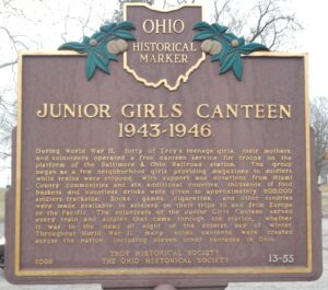
During World War II, forty of Troy’s teenage girls, their mothers, and volunteers operated a free canteen service for troops on the platform of the Baltimore & Ohio Railroad station. The group began as a few neighborhood girls providing magazines to soldiers while trains were stopped. With support and donations from Miami County communities and six additional counties, thousands of food baskets and countless drinks were given to approximately 600,000 soldiers trackside. Books, games, cigarettes, and other sundries were made available to soldiers on their trips to and from Europe or the Pacific. The volunteers of the Junior Girls Canteen served every train and soldier that came through the station, whether it was in the dead of night or the coldest day of winter. Throughout World War II, many other canteens were created across the nation, including eleven other canteens in Ohio.
, OH
Formed by the retreating glacier more than 14,000 years ago, Buckeye Lake first existed as a shallow, swampy pond, named “Buffalo Swamp” by Ohio Company explorer Christopher Gist in 1751. Beginning in 1826 the State developed it as a water source for the Licking Summit of the Ohio and Erie Canal, it being the highest level between the Scioto and Licking rivers. Engineers dammed the north and west sides of the swamp, inadvertently creating a unique floating sphagnum-heath bog surrounded by water. Cranberry Bog, with boreal vegetation typical of glacial-era Ohio, is a registered National Natural Landmark. (continued on other side)
, OH
On April 1, 1818, six families from the Cilcennin area of Mid-Wales sailed from Aberaeron, Wales to Baltimore. The group of 36 people was led by John Jones Tirbach. From Baltimore they traveled to Pittsburgh and then by flatboats down the Ohio River toward their destination-Paddy’s Run in Butler County in the southwest corner of Ohio. They stopped in Gallipolis for provisions where their boats were cut loose by either travel-weary women or citizens of Gallipolis who wanted them to stay. The men found work on the Gallipolis to Chillicothe road that was under construction. The terrain reminded them of Mid-Wales, so they purchased land near Centerville and remained. These Welsh prospered and wrote home to Wales with news of their success, prompting others to come. (continued on other side)
, OH
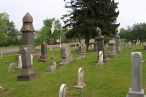
Settlers from Connecticut were the first to come to Canfield Township in the late 1700s, and they were followed by a second wave of immigrants, Swiss-German pioneers who began arriving from Berks and Leigh counties in Pennsylvania in 1804. In 1810, these “Pennsylvania Dutch” established The Zion Lutheran and Reformed Church and built a log church and cemetery on this site. The church was destroyed by fire in 1845 and a new church served the congregation well until it too was destroyed by fire in 1894. The cemetery, known as The Old Dutch and German Burying Ground, German Cemetery, and Lynn Cemetery and now Old North Cemetery, is all that remains. Among the dozens of old stone markers, some in German, are markers for veterans of the American Revolution, War of 1812, Civil War, and other wars.
, OH
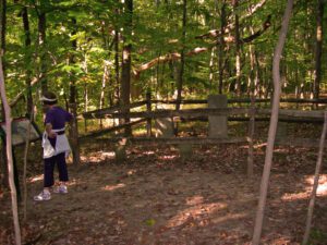
Congress established the United States Military District in 1796 by an act to provide bounty land for Revolutionary War officers and soldiers. District lands consisted of 2.6 million acres in twelve Ohio counties, including Delaware County. The Union Land Company, organized by James Kilbourne of Connecticut in 1806, was formed to purchase Military District land. Kilbourne purchased 4,000 acres in southeast Liberty Township, Delaware County for $7,000, and, in turn, sold the land to 26 Union Land Company members for $2.00 per acre. Five members were from the Case family, and they purchased 950 acres–Ambrose, George, Jonathan, Seth, and Silas. George and Seth were Revolutionary War veterans who did not claim their bounty lands. George purchased lot 11, a part of which is in northwest Highbanks Park today, and Seth purchased 300 acres north of this site. By 1849 the Case family owned over 1,000 acres.