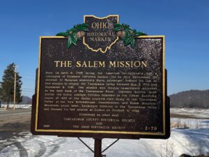
Here, on April 6, 1780 during the American Revolutionary War, a contingent of Delaware Christian Indians, led by John Heckwelder, an assistant to Moravian missionary David Zeisberger, founded the last of five missions to occupy the Tuscarawas Valley between May 3, 1772 and September 8, 1781. The mission was located immediately adjacent to the west bank of the Tuscarawas River. Eighteen months later, British led Indian soldiers forcibly removed to the Upper Sandusky region all 400 of the Indian converts then living in the Tuscarawas Valley at the New Schoenbrunn, Gnadenhutten, and Salem missions. Seventeen years later, Zeisberger returned to the Tuscarawas Valley and founded his last mission at Goshen on October 4, 1798.
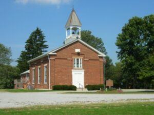
On this site in 1809, pious Christians from Virginia and North Carolina erected a Methodist Church, the first in Greene County. The church was officially organized on May 23, 1807 as the Bonner Society. Frederick Bonner, Sr. and the illustrious Rev. John Sale were the principal organizers. This Methodist Church, one of the oldest in Ohio, has been serving the area known as the Union Neighborhood uninterrupted from this site since 1809. Rev. Bennett Maxey was the first pastor. (Continued on other side)
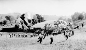
On a stormy autumn morning in 1925, the giant Navy airship, christened Shenandoah, crashed near this site. Initially, the Shenandoah was commissioned to perform scouting missions for the Navy; however, she would soon be flying promotional missions. The Shenandoah had recently begun a six-day publicity tour across the Midwest when she crashed. The turbulent weather of late summer created strong winds, which ripped the 680-feet long Shenandoah in two and tore the control car from the keel. A majority of the 14 crewmen who died in the crash, including the captain, Lt. Commander Zachary Lansdowne of Greenville, Ohio, were killed when the control car plummeted to the ground. The stern section fell in a valley near Ava and the bow was carried southwest nearly twelve miles before landing near Sharon, Ohio. The Ohio National Guard was called in to control the crowds of spectators who traveled to the crash sites.
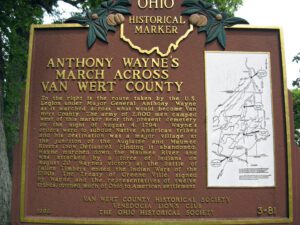
To the right is the route taken by the U.S. Legion under Major General Anthony Wayne as it marched across what would become Van Wert County. The army of 2,800 men camped west of this marker near the present cemetery on the night of August 4, 1794. Wayne’s orders were to subdue Native American tribes and his destination was a major village at the junction of the Auglaize and Maumee Rivers (now Defiance). Finding it abandoned, Wayne marched down the Maumee River and was attacked by a force of Indians on August 20. Wayne’s victory at the Battle of Fallen Timbers ended the Indian Wars of the 1790s. The Treaty of Greene Ville, signed by Wayne and the representatives of twelve tribes, opened much of Ohio to American settlement. Side one includes a map on the right hand side of the marker showing the route of Wayne’s army through the eastern third of Van Wert County.
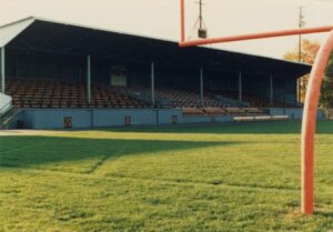
Opened in 1926, Tanks Memorial Stadium became the home of the Ironton Tanks semi-professional football team. The Tanks were formed in 1919 and through the years played other semi-professional teams as well as teams from the American Professional Football Association that became the National Football League in 1930. In twelve seasons the Tanks had a record of 85 wins, 19 losses, and 14 ties, including wins against the Chicago Bears and New York Giants. The Tanks disbanded in 1931, but five players moved on to the Portsmouth Spartans, which became the Detroit Lions, and other NFL teams picked up four other players. Tanks Memorial Stadium is one of the few remaining roofed high school football stadiums in the country.
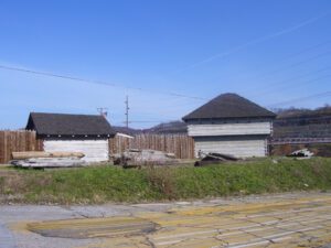
In 1787, the construction of Fort Steuben was completed by Captain John Francis Hamtramck and soldiers of the 1st American Regiment, who were sent to the frontier by the United States government to remove illegal squatters and protect government surveyors from American Indian raids. The surveyors were platting the First Seven Ranges of the Northwest Territory. The surveyed land was sold for settlement or offered to soldiers as payment for military service during the Revolutionary War. Consequently, the states of Ohio, Illinois, Indiana, Michigan, and Wisconsin were formed from the settlement of the Northwest Territory. Fort Steuben was named after Baron Frederich Wilhelm Augustus Steuben, who had served in the Revolutionary War and from which the town derived its name. Captain Hamtramck abandoned the fort in 1787 by order of Colonel Josiah Harmar, and by 1790 the remains of the fort had disappeared. Fort Steuben has been reconstructed on its original location.
Intersection of Main Street and Township Road 39 (High Street)
Roundhead
, OH
Upon this site, in the late 18th and early 19th centuries, stood Chief Roundhead’s Wyandot Indian village. This flourishing agricultural community later gave way to white settlement and Hardin County’s first town was laid out here in 1832. Roundhead, or Stiahta, was celebrated for his capture of American General James Winchester during the War of 1812. Roundhead is believed to be buried in this vicinity.
After American militia troops forcibly ended the 1812 siege of Fort Wayne, General James Winchester’s Army of the Northwest marched down the north side of the Miami [Maumee] River to stop or retard advancing British troops sent to aid in the siege of Fort Wayne. After three days of difficult march, Ensign James Liggett of the 17th Regiment, volunteered to lead a group of four spies or scouts to the site of the old Fort Defiance. Liggett’s small force was surprised and killed on or about September 25 near here. The Americans tried twice to recover the bodies, but met with ambush from hostile Native Americans sympathetic to the British. Their bodies were finally recovered and buried in a common grave. Besides Liggett, they included Wyatt Stepp, Guy Hinton, William Bevis, and Nathaniel Mitchell of Woodford County, Kentucky, all of Captain McCracken’s Company, 1st Rifle Regiment, Kentucky Volunteer Militia.