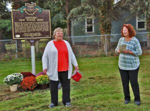
New Haven, Ohio, was the mercantile center of southwest Huron County during the first half of the 19th century. Residents described immense wagons, or “land schooners,” lined up for miles on the New Haven-Worthington Road traveling from Columbus to the Lake Erie ports. Organized in 1815, New Haven was one of the early townships formed in Huron County and the Firelands. The village was platted, with streets at right angles around a diamond-shaped town green, after the plan of New Haven, Connecticut. When, in the 1840s, New Haven rejected the railroad’s direct route through the village, the Sandusky & Newark was routed to the west and through Plymouth taking with it the shipping business. Subsequently, New Haven began a steady economic decline into a small crossroads village.
Hector Kilbourne, a Freemason and the surveyor who make the original plat of Sandusky (as Portland) in 1816, laid out the streets to form the Masonic emblem. Huron and Central Avenue are the arms of the compass, Elm and Poplar Streets the sides of the mason’s square. The first Masonic Lodge in Sandusky was founded in 1819, with Kilbourne as Master.
The Wyandot called the Grand Reserve home nearly a century before Ohio statehood. They built houses, cultivated the land, and grew bountiful groves of fruit trees. They governed from the nearby Wyandot Council House and operated a productive saw and grist mill. Many sent their children to school and worshiped at the limestone church, built in 1824, and recognized as the first Methodist mission in the country. But Ohioans set their sights on Wyandot lands in the fertile Sandusky River Valley. State and federal governments were unwilling to allow the Wyandot to remain on their chosen homelands, despite their participation in American society and friendly relations with neighboring settlers. Following the Indian Removal Act of 1830, the Wyandot were the last tribe removed from the State of Ohio in 1843.
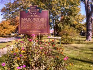
This is the site of Camp Noble, named for Congressman Warren P. Noble, who obtained the officer’s commission for William H. Gibson as the colonel of the 49th Ohio Volunteer Infantry. Companies of 100 began to arrive here August 12, 1861 from Crawford, Hancock, Putnam, Sandusky, Seneca, and Wyandot Counties. On August 20, they were mustered into Federal service as the 49th Ohio Volunteer Infantry. Nicknamed the “Buckeye Vanguard” by Col. Gibson, training continued until September 9, 1861, when the 49th was ordered to Camp Dennison, near Cincinnati, Ohio. (Continued other side)
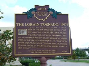
Just after 5:00 P.M on June 28, 1924, a tornado swept off Lake Erie directly into downtown Lorain. Within five minutes, seventy-eight people lost their lives. Fifteen died in the old State Theatre that stood upon this site, as an audience of two hundred watched a Saturday afternoon musical performance. More than one thousand suffered injuries. The tornado did extensive damage to the business district, destroyed 500 homes, and damaged a thousand more. The city’s largest industry, the American Shipbuilding yards, was severely damaged. The tornado, which had hit Sandusky before striking Lorain, continued along the shoreline and struck Sheffield and Avon minutes later. Contemporary accounts listed eighty-two deaths resulting from the deadliest tornado in Ohio’s history.
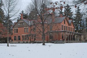
The twenty-five acre estate Spiegel Grove was the home of Rutherford Birchard Hayes, the 19th president of the United States. Spiegel Grove received its name from the German word “spiegel,” meaning mirror, describing pools that collect beneath the trees after a rainstorm. Hayes’s uncle, Sardis Birchard, a Fremont merchant, built the home on this site in 1863. The Hayeses moved to Spiegel Grove after Hayes’s second term as Ohio governor ended in 1873. They inherited the estate in 1874. The family left Fremont after Hayes’s election as Ohio governor in 1875, and U.S. president in 1876. They returned to Spiegel Grove in 1881. The Hayeses expanded the home in 1880 and 1889. Lucy and Rutherford Hayes died at Spiegel Grove in 1889 and 1893 respectively. They were reburied at Spiegel Grove in 1915. Their children donated the property to the state of Ohio in 1909 in order to establish the nation’s first presidential library.
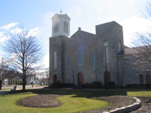
This building was begun in 1835 and was completed in 1844. It is the oldest church building in continual use in Sandusky and incorporates a portion of the original structure. This marker commemorated the one hundred fiftieth anniversary of the laying of the cornerstone and the church’s sesquicentennial observance in 1985.
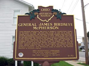
James Birdseye McPherson was born in Hamer’s Corners (now Clyde) on November 14, 1828. He left this house at age 13 to work in nearby Green Springs. He attended Norwalk Academy and West Point, where he graduated first in the class of 1853. Early in the Civil War, he was appointed by General Ulysses S. Grant to command the Army of the Tennessee. He received the rank of Major General with the United States Volunteers in October 1862 and was promoted to Brigadier General in the Regular Army in August 1863. He was killed in action during the battle of Atlanta, Georgia on July 22, 1864. General McPherson was the youngest and highest ranking Union officer killed in the Civil War. He is buried in the local McPherson Cemetery. This McPherson home is listed on the National Register of Historic Places.