Anson Williams visited Ohio in 1834 before he moved to Orange Township. A former resident of New York State, Williams purchased this site and the surrounding 1,000 acres of U.S. Military District lands and hoped to find opportunity for himself and his family. He bought the land for $6.00 an acre from James D. Wolf, who owned the 4,000-acre section three of Orange Township. The Village of Williamsville was laid out with 80 lots in 1836 on both sides of the Columbus and Sandusky Turnpike. Williams built his home and a hotel with a store and tavern. A hotel and tavern, owned by George Gooding and where the stage changed horses, had already been established north of Williamsville. Competition may have led to Williamsville’s decline. A church was built in 1845 and remained until 1900. Anson died in 1847, and his wife Hannah passed away in 1851. Both are buried in nearby Williamsville Cemetery.
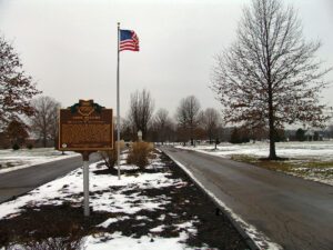
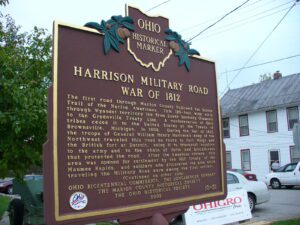
The first road through Marion County followed the Scioto Trail of the Native Americans. This 120-foot wide strip through Wyandot territory led from Lower Sandusky (Fremont) to the Greenville Treaty Line. A confederation of Ohio tribes ceded it to the United States at the Treaty of Brownsville, Michigan, in 1808. During the War of 1812, the troops of General William Henry Harrison’s Army of the Northwest traveled this road en route to Fort Meigs and the British fort at Detroit, using it to transport supplies to the army and to the chain of forts and blockhouses that protected the road. After the American victory, this area was opened for settlement by the 1817 Treaty of the Maumee Rapids, and soldiers who discovered the area while traveling the Military Road were among the first settlers. (continued on other side)
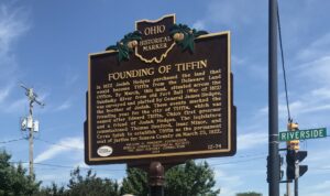
In 1822 Josiah Hedges purchased the land that would become Tiffin from the Delaware Land Office. By March, this land, situated across the Sandusky River from old Fort Ball (War of 1812) was surveyed and platted by General James Hedges, the brother of Josiah. These events marked the founding year for the city of Tiffin, which was named after Edward Tiffin, Ohio’s first governor and a friend of Josiah Hedges. The legislature commissioned Thomas Henford, Isaac Minor and Cyrus Spink to establish Tiffin as the permanent seat of justice for Seneca County on March 25, 1822.
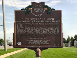
Following the Civil War, many of Ohio’s disabled and wounded veterans found inadequate provisions for their long-term needs. In response, the Grand Army of the Republic’s Department of Ohio lobbied for a state-operated veterans’ home. In 1886 Governor Joseph B. Foraker signed a bill establishing the Ohio Soldiers’ and Sailors’ Home for honorably discharged veterans. A board of trustees led by Sandusky publisher I.F. Mack selected the site, and the Sandusky community donated the tract of land, utilities, and a connection to the Baltimore and Ohio Railroad. The facility opened in November 1888. (continued on other side)
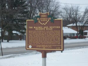
Sandusky Street (U.S. Highway 20) is the former Maumee and Western Reserve Turnpike. Native American tribes northwest of the Ohio River ceded the right of way for this 46-mile road to the federal government in the Treaty of Brownstown in 1808. This narrow strip ran in a nearly straight line from the lower Maumee River rapids through the Black Swamp to the boundary of the Western Reserve, and included one mile of land on either side of the 120-foot wide road. In 1823 Congress gave the land to the state of Ohio, and a crude roadway was cleared by 1827. Land sales financed roadbuilding and maintenance. Notoriously impassible during the wet seasons, the “Mud Pike” was surfaced with gravel in 1838.
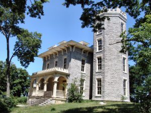
Completed in 1865, this home was the vacation retreat of Jay Cooke and his family. Known as the “financier” for the Union states during the Civil War, Cooke organized a program to sell millions of dollars worth of bonds to support the war effort. The house is of a high Victorian Italianate mode with a Gothic style tower topped with crenellations. Distinctive hood moldings outline windows and over-scaled and ornamental brackets support crowning cornices. The house, commonly known as Cooke Castle, hosted many notables of the time, including William T. Sherman, William Howard Taft, Rutherford B. Hayes, Salmon Chase, and John Brown, Jr. Born in Sandusky in 1821, Cooke, an avid fisherman, acquired the island for $3,001 in 1864. University trustee Julius Stone gave the island to The Ohio State University in 1925. The house was placed on the National Register of Historic Landmarks in 1966.
Congress established the United States Military District in 1796 by an act to provide bounty land for Revolutionary War officers and soldiers. District lands consisted of 2.6 million acres in twelve Ohio counties, including Delaware County. The Union Land Company, organized by James Kilbourne of Connecticut in 1806, was formed to purchase Military District land. Kilbourne purchased 4,000 acres in southeast Liberty Township, Delaware County for $7,000, and, in turn, sold the land to 26 Union Land Company members for $2.00 per acre. Five members were from the Case family, and they purchased 950 acres–Ambrose, George, Jonathan, Seth, and Silas. George and Seth were Revolutionary War veterans who did not claim their bounty lands. George purchased lot 11, a part of which is in northwest Highbanks Park today, and Seth purchased 300 acres north of this site. By 1849 the Case family owned over 1,000 acres.
Following the Civil War, many of Ohio’s disabled and wounded veterans found inadequate provisions for their long-term needs. In response, the Grand Army of the Republic’s Department of Ohio lobbied for a state-operated veterans’ home. In 1886 Governor Joseph B. Foraker signed a bill establishing the Ohio Soldiers’ and Sailors’ Home for honorably discharged veterans. A board of trustees led by Sandusky publisher I.F. Mack selected the site, and the Sandusky community donated the tract of land, utilities, and a connection to the Baltimore and Ohio Railroad. The facility opened in November 1888. (continued on other side)