

, OH
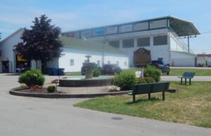
In 1846, the same year that Mahoning County was created, Ohio’s General Assembly passed an act “for the encouragement of agriculture.” An outgrowth of this legislation led to the founding of the Mahoning County Agricultural Society in April 1847. Boasting a membership of 170, the Society agreed to sponsor competitions for premiums to be distributed at an “annual fair and cattle show the next fall.” Canfield was the geographic center of the county and selected as the site for the first fair. In October, from the lawn of the First Congregational Church, Comptroller of the United State Treasury Elisha Whittlesey welcomed participants. Admission was one shilling (twelve and one half cents). The Village Green overflowed with exhibitions of prized livestock, harvests, plowing contests, and horse racing. Early fairs were one-day events attended primarily by gentlemen. However, the church provided a venue for ladies to display their handiwork. (continued on other side)
, OH
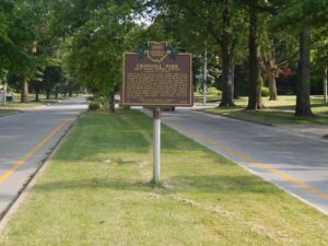
Crandall Park is the heart of the historic district and includes Fifth Avenue, Redondo Road, Catalina Avenue, and Tod Lane. Most of the district’s historic structures were built between 1904 and 1930, Youngstown’s heyday as an urban and industrial center. The district encompasses 92 houses, 32 outbuildings, a pavilion and rustic stone shelter in Crandall Park, and the concrete arch bridge carrying Fifth Avenue over the park. The North Heights Land Company and the Realty Guarantee Trust Company developed much of the neighborhood. Homes in the district were built for the city’s prominent industrialists and businessmen. The houses feature the work of architects Morris Scheibel, Charles F. Owsley, Fred Medicus, Barton Brooke, and Cook and Canfield and are distinguished by their grand scale, high-style design, spacious lots, landscaping, and orientation to the park or boulevard roads. (Continued on other side)
, OH
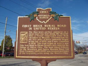
In the late nineteenth century, a movement to improve inadequate plank and dirt roads was brought on by the popularity of bicycling, the introduction of the automobile, and the need to improve travel to and from rural areas. Ohio, as a leader in the manufacture of brick paving blocks, was quick to upgrade roads. Toll roads were waning in popularity and the need for free roads was recognized. An act passed in 1892 authorized Cuyahoga County to levy a road tax. With funds levied, the Commissioners selected the Wooster Pike as one of three road improvement projects.
, OH
Sylvania was once the headquarters for the Toledo and Western Railway, an electric interurban line that provided service between Toledo and Pioneer with a branch line to Adrian, Michigan. Construction began here in 1900 with planning and specifications set to steam railroad standards. With completion of rails, a powerhouse, maintenance facilities, and offices, the Toledo and Western Railway Company was soon in the business of providing freight and passenger service and was especially competitive as it owned more freight engines than most interurban lines. Operating an electric interurban line also meant that the company had the ability to provide electricity to people living in Sylvania and to other communities and property owners living along the line’s right-of-way. Besides freight, passengers, and electricity, Toledo and Western also provided postal service, one of the first interurban lines to do so. [continued on other side]
, OH
A network of Native American trails, usually following waterways, traversed Ohio and often determined the routes of military roads and improved highways. U.S. Route 33 follows the route of the Scioto Trail from the confluence of the Scioto and Olentangy rivers to State Route 161, where U.S. Route 33 becomes State Route 257. The Scioto Trail extended from the mouth of the Scioto River at Portsmouth (also known as Shawnee Town) to Sandusky Bay and connected the Shawnee’s hunting grounds in Kentucky with Lake Erie. The trail ran along the Scioto River, the Little Scioto River, and the Sandusky River with a portage between the Little Scioto and Sandusky rivers in Crawford County. The Scioto Trail, used for warfare, trade, and migration, was one of the most important trails in the Old Northwest.
, OH
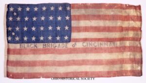
Following the success of Confederate forces in eastern Kentucky and General John Hunt Morgan’s raids there in 1862, Cincinnatians believed that Southern invasion was imminent. Anxious officials ordered Cincinnati citizens to form home guards, but black men willing to volunteer were rebuffed when they attempted to join a defense force. Instead, police serving as provost guards rounded up many and marched them by bayonet to build fortifications in Kentucky. Reacting to the shameful treatment of the blacks eager to support the Union, the commander of the Department of Ohio dispatched Major General Lewis Wallace to command the civilians and to liberate black men forced into service. (continued on other side)
, OH
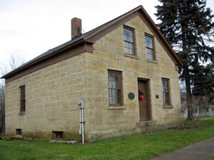
This rare sandstone house was built for Austin (c. 1788-1848) and Roxanna (Sears) Lilly (c. 1793-1868). They came to Dover Township (now Westlake) in 1832 from Ashfield, Massachusetts, an area from which many Dover settlers originated. This lot had been owned by Ozias and Hiram Smith. The Lillys erected this house in about 1844 and lived here until 1867. It is made with sandstone blocks two feet thick, finely tooled and dressed in the front and less elaborately on the sides and rear. The basement is constructed with massive rectangular stone blocks. Thick hewn timbers support the massive roof structure. A brick wing was attached to the east side in about 1850. After 1867, the lot and house had several owners, including George Weston, James Beardsley, and August Trudel. Eventually, Alice (Mrs. Dezso) Ladanyi, the great granddaughter of George Weston, deeded the house to the city of Westlake for use as a museum.
, OH
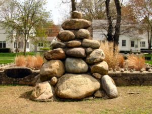
The cemetery dates to 1794 and is comprised of two adjacent cemeteries: Columbia Presbyterian Cemetery and Fulton Cemetery. Another cemetery, the Fulton Mechanics Cemetery, had been in Fulton, a village along the Ohio River and a center of boat-building and steamboat construction during the first half of 19th century. Together, the cemeteries are the burial places of Jacob Allen, John Campbell, John Langdon, and other veterans of the Revolutionary War. It is also believed that William Brown is buried here. Brown was one of three soldiers during the Revolutionary War to receive the Badge of Military Merit, predecessor of the Purple Heart. The cemetery was listed on the National Register of Historic Places in 1979. (Continued on other side)