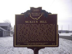
Following the American Revolution, the British Crown sought to retain possession of the Ohio Country by sending chief British Indian Agent Alexander McKee and others to establish trading posts with Native Americans and resist American settlement. In 1786, Colonel Benjamin Logan led an American force against the British posts and tribes. Warned of their approach, McKee and a band of Shawnee, took their possessions, including a large drove of hogs, and fled north from the Mackachack Villages near present-day Bellefontaine. Their route was the Black Swamp Trail, now Napoleon Road. An attempted crossing of the rain-swollen Ottawa River turned disastrous, resulting in the loss of possessions and most of the hogs. The hill upon which the party camped following the failed crossing, located one half mile east of here, became known as McKee’s Hill, and the portion of the Ottawa River east of Lima has since been known as Hog Creek.
Originally called St. Clairsville and platted in 1801, Decatur was named for early 19th century naval hero Stephen Decatur. It is among the oldest villages in Brown County, which before 1817 was a part of Adams County. Among its notable early residents were Nathaniel Beasley (1774-1835), the first surveyor of Adams County, and Sarah Boone Montgomery (1763-1848), a heroine of the border wars in Kentucky. Decatur and Byrd Township supported at least four known stations on the Underground Railroad. Many area residents helped conduct escaping slaves northward to freedom.
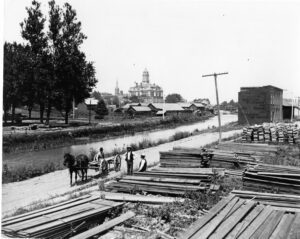
Miami & Erie Canal and Napoleon’s First Cemetery. The Miami & Erie Canal stretched approximately 250 miles from Cincinnati to Toledo. Napoleon and other towns on the Maumee River’s banks were on a slackwater section of the canal. Between 1825 and 1845, laborers constructed the canal using shovels, picks, wheelbarrows, and horse and mule-drawn carts. In Henry County, Napoleon, and elsewhere, German and Irish immigrants and area farmers did the work and were paid around 30 cents a day. As the canal brought more people and business to the area, villages such as Florida, Damascus, and Texas flourished and the county seat of Napoleon boomed. The canal and consequent growth took their tolls, however. Sickness and disease such as “ague” (malaria) and cholera spread and carried off many. Napoleon’s first cemetery was located in the vicinity of 500 East Clinton Street, near the route of the canal.
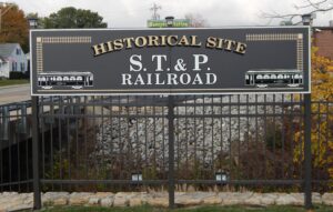
Asa Bushnell, former Governor of Ohio, encouraged by the light grade of the land, decided to establish the Springfield, Troy, and Piqua Railway (ST&P) in July 1904. The interurban traction line utilized sixty-pound rail and traveled over only one bridge. With direct current electricity generated in Springfield, the ST&P used four double-ended fifty-foot cars, each with a railroad roof, arch windows, GE-57 engines, and fifty-horsepower motors. The ST&P traveled from Springfield’s Fountain Square to Maitland, Hill Top, Lawrenceville, Bushnell, North Hampton, Dialton, Thackery, Proctors, Christiansburg, Brights, and Casstown and ended at Troy’s North Market Street Bridge. Later rights were granted to travel over the Great Miami River into Troy in conjunction with the Cincinnati, Hamilton, and Dayton Railway. The northwest right-of-way from Casstown to Piqua was secured but never built.
The pioneer village of Vistula is now bounded by Walnut, Champlain, Chestnut, Magnolia, and Summit streets. Established in 1833 by Benjamin F. Stickney and Edward Bissell, Vistula was merged with its rival, Port Lawrence, and in 1837 both villages were incorporated as Toledo. The Vistula Historic District, Toledo’s oldest neighborhood, was listed on the National Register of Historic Places in 1978.
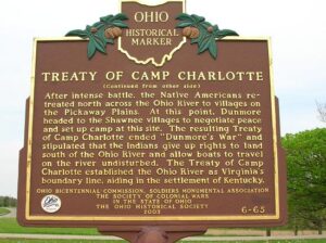
In an effort to maintain peace with Native Americans, the British imposed the Proclamation Line of 1763, which prohibited colonial settlement west of the Appalachian Mountains. Some settlers did not recognize British authority and continued to move westward. Virginia Governor Lord Dunmore, realizing that peace with Native Americans was improbable, amassed troops and headed west, camping at the Hocking River to meet with a unit commanded by Andrew Lewis. En route, Lewis’s troops were attacked on October 10, 1774 at present day Point Pleasant, West Virginia, by a force of Delaware and Shawnee led by Cornstalk.
In 1834, immigrant families from the Upper Rhine River Valley villages of Mulhausen (France) and Schaffhausen (Switzerland) first met in Marshallville, Ohio. They decided to travel west by canal boat and purchase farmland in what became Fulton County in 1850. Joseph Bates, a knowledgeable hunter and navigator, brought them to German Township. On August 22, 1834, Bates and his hired men erected a log cabin for Christian Lauber and the first families arrived at “Lauber Hill” the following day. The farming community grew and by the 1880s included a Reformed Mennonite Church, a German Baptist Church, a Froehlich Evangelical Church, the Barneth (Bernath) one-room school, the Werrey Cabinetmaker’s Shop, the Roth Sawmill, the Uhlrich Wagon Shop, the Wise Brickworks, and the Leu Blacksmith Shop.
Clinton County was a major center of activity for the Shawnee, Miami, and Delaware Indians. Early traces and trails developed as Indians traveled from village to village; gathered flint, salt and gold; traded furs, mica, and feldspar; and hunted bear, deer, otters, raccoons, foxes, wild cats, turkeys, and other wildlife. Trails throughout the county connected to other trails and villages in Ohio such as Lower Shawnee Town (now Portsmouth), Hurricane Tom’s Town (now Piketon), Chillicothe, Old Town (near Xenia), and Miami Town (now Dayton). Major trails or traces in Clinton County included the Bullskin, Wayne, Chillicothe, Delaware, Fort Ancient, Kanawha, Kenton and Todds Fork Traces. These routes were the avenues the first white settlers followed. (continued on other side)