A prominent early 20th century illustrator and artist, Howard Chandler Christy was born on a farm in Morgan Township. He first gained notice as an illustrator during the Spanish-American War, but achieved lasting fame for his trademark “Christy Girls,” dream girls who idealized feminine beauty during this era. Between 1908 and 1915, he worked from a studio perched above the Muskingum River near Duncan Falls. In the 1920s Christy began to paint portraits and historical scenes. The Signing of the Constitution of the United States, displayed in the Capitol, is his most famous work. The Signing of the Treaty of Green Ville hangs in the Ohio Statehouse.
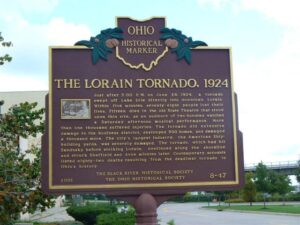
Just after 5:00 P.M on June 28, 1924, a tornado swept off Lake Erie directly into downtown Lorain. Within five minutes, seventy-eight people lost their lives. Fifteen died in the old State Theatre that stood upon this site, as an audience of two hundred watched a Saturday afternoon musical performance. More than one thousand suffered injuries. The tornado did extensive damage to the business district, destroyed 500 homes, and damaged a thousand more. The city’s largest industry, the American Shipbuilding yards, was severely damaged. The tornado, which had hit Sandusky before striking Lorain, continued along the shoreline and struck Sheffield and Avon minutes later. Contemporary accounts listed eighty-two deaths resulting from the deadliest tornado in Ohio’s history.
The Wyandot called the Grand Reserve home nearly a century before Ohio statehood. They built houses, cultivated the land, and grew bountiful groves of fruit trees. They governed from the nearby Wyandot Council House and operated a productive saw and grist mill. Many sent their children to school and worshiped at the limestone church, built in 1824, and recognized as the first Methodist mission in the country. But Ohioans set their sights on Wyandot lands in the fertile Sandusky River Valley. State and federal governments were unwilling to allow the Wyandot to remain on their chosen homelands, despite their participation in American society and friendly relations with neighboring settlers. Following the Indian Removal Act of 1830, the Wyandot were the last tribe removed from the State of Ohio in 1843.
Colonel Ebenezer Zane played a major role in the development of Ohio, a role that helped place it on the path to statehood. A veteran of the Revolutionary War and experienced road builder, he received permission from Congress in 1796 to build a road into the Northwest Territory, which would be called Zane’s Trace. In exchange for his work, Zane received land grants where the trace would cross the Muskingum, Hocking, and Scioto rivers. The trace began in Wheeling, West Virginia (then Virginia) and ended at Limestone, Kentucky (present-day Maysville) on the Ohio River. Opening in 1797, it brought settlement into Ohio, including Lancaster. Its route crossed the playground area of East Elementary from the northeast corner of today’s playground to the southwest corner, lot #18, East Addition, as recorded on an 1897 map of Lancaster.
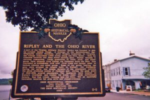
A part of the Virginia Military District, Ripley was founded in 1812 by Colonel James Poage, a veteran of the Revolutionary War. Originally named Staunton, after Poage’s hometown in Virginia, the village comprised 1,000 acres along the Ohio River. With its riverside location and deep water landing area, Ripley became a thriving community. Large quantities of flour, pork, and other goods were shipped from Ripley via flatboats down the Ohio. This continued as steamboats took over river trade and cargos came to include tobacco and other goods. Some of the goods leaving the area were shipped on vessels built in Ripley’s two boatyards. During the early and middle decades of the nineteenth century, the yards produced scores of flatboats and, during the peak years of 1826-1836, several steamboats. The boatyards were located on Ripley’s riverbank and lumber for boats came from surrounding forests. Red Oak Creek, running into the Ohio, was an especially favorable location for area mills and slaughterhouses.
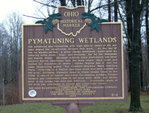
The advancing and retreating mile-high glacial sheet of ice and snow shaped the countryside around this area. As the last of the ice masses melted, a great swamp developed, punctuated by towering white pines, bogs, and wetlands, fed by the Shenango and Beaver rivers. Abundant wildlife drew prehistoric and later historic Native Americans into the area where they lived and hunted for thousands of years. Indian legend has it that the name Pymatuning means “The Crooked-Mouthed Man’s Dwelling Place,” referring to a Native American chief who once resided in the area. European trappers came to these swamp lands in the 1700s in search of beaver and other fur-bearing animals. Pioneer farmers and lumbermen came to the area after 1800, but settlement in the swamp was slow and difficult. Eventually much of the area was cultivated in onions and other root crops. (continued on other side)
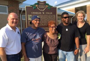
Charles W. Follis was born on February 3, 1879, in Virginia. His family moved to Wooster where he attended Wooster High School and helped establish the school’s football team. In 1901, Follis enrolled and played baseball at the College of Wooster and played football for the Wooster Athletic Association where he earned the nickname “The Black Cyclone from Wooster.” In 1904, Follis signed a contract to play football with Shelby Athletic Club, making him the first African-American professional football player. Follis faced discrimination on and off the field leading to many injuries. After a career-ending injury in 1906, Follis played baseball for the Cuban Giants of Long Island. He died of pneumonia in 1910 at the age of 31 and is buried in Wooster Cemetery.
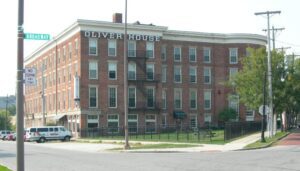
Overlooking the “Middlegrounds,” an early site of railroad, immigration, and commercial activity, the Oliver House opened in 1859 as Toledo’s premier hotel. It was designed by nationally prominent architect Isaiah Rogers, in the Greek Revival style, and built by the family of William Oliver for whom the hotel was named; owner of this land, Oliver was one of Toledo’s earliest real estate investors. (Continued on other side)