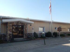
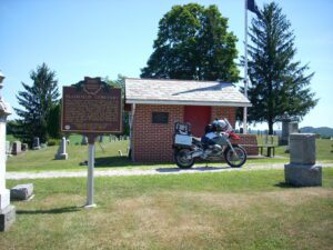
The completion of the Wabash and Erie Canal on July 4, 1843 brought many new settlers into this region. The Wabash and Erie Canal connected with the Miami and Erie Canal at Junction. Antwerp, ideally located on the Maumee River, was seen as a perfect place in which to establish a town. That same year surveyors W. Wilshire Riley and Samuel Rice platted what would become Antwerp. Naming rights belonged to Riley and storeowner Horatio N. Curtis, who wanting a name not duplicated anywhere else in the country, named it after Antwerp, Belgium. Early pioneers subdued the massive forests that once formed the “Black Swamp” and built a thriving city. Antwerp was incorporated in 1863. (continued on other side)
A migration of Indians throughout Ohio began due to unstable conditions created by the American Revolution. The massacre of Christian Indians at the Moravian mission of Gnadenhutten in 1782 and Colonel William Crawford’s expedition against Wyandot and Delaware towns along the Sandusky fueled insecurities. Delaware, including a small group of Mingo Indians, abandoned the village of Helltown, five miles southwest of this site, and settled Greentown as early as 1783. Greentown, situated on an elevation on the Black Fork beyond the clearing behind this site, was presumably named for British loyalist, Thomas Green. John Chapman (Johnny Appleseed) had an amicable relationship with the Delaware, owned land throughout the Black Fork Valley, and was known to visit Greentown on his travels throughout Ohio. Other visitors to the village included the Shawnee Prophet; Munsee Delaware leader, Captain Pipe; and local preacher, James Copus.
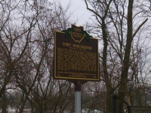
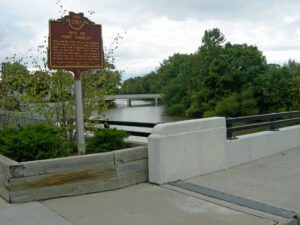
General William Henry Harrison ordered the construction of Fort Winchester at the beginning of October 1812 and it was completed October 15. The fort served as a forward observation post and supply depot for the American army during the War of 1812. Until Fort Meigs was completed in 1813, Fort Winchester was the front line against the British and their Indian allies. During the siege of Fort Meigs, Fort Winchester was a rendezvous point for the troops of General Green Clay and those of Colonel William Dudley. Fort Winchester outlined the shape of a parallelogram, measuring 600 by 300 feet in size. Blockhouses anchored the four corners of the fort and within its stockade were storehouses and a hospital.
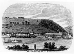
Ripley was incorporated as the village of Staunton in 1812. Its name was changed in 1816 to honor General Eleazer Wheelock Ripley, a hero of the War of 1812. In the years before railroads, Ripley was a principal Ohio River shipping center. Also important were its extensive boat-building, tobacco, pork, and timber industries. Ripley too was the home of saw and planing mills, iron foundries, and a piano factory. Such varied commerce enabled Ripley to remain vibrant throughout the nineteenth century. Although noted as a port, Ripley is best remembered as an abolitionist stronghold. Many of its citizens, including Rev. John Rankin and John P. Parker, served as conductors on the famed “Underground Railroad.” The notoriety of Ripley’s anti-slavery network perhaps eclipsed that of nearby Cincinnati, earning the town a reputation as the “Black Hole of Abolitionism.” (Continued on side two)
This cemetery, established in 1810, is the final resting place of many of the founders of Plainfield and Linton Township. Besides the early date of its founding, it is notable for the number of armed forces veterans interred here, who represent every major conflict since the Revolutionary War. The graves of eighty-nine Civil War soldiers-a number nearly equal to those of veterans involved in all other wars between the War of 1812 and the Vietnam War-indicate the depth of Plainfield’s involvement in that conflict.
Early in the War of 1812, Gen. Wm. Hull, commander of Ohio troops, ordered Col. James Findlay to open a road from Ft. McArthur on the Scioto River to Blanchard’s Fork. Under Findlay, a stockade 50 yards square, with a blockhouse at each corner, was erected here and named in his honor. The fort was used as a supply depot.
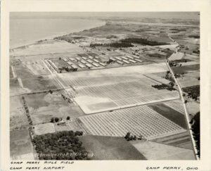
In an effort to improve the marksmanship of Ohio soldiers, Adjutant General Ammon B. Critchfield established Camp Perry, an Ohio National Guard Military Training site on the shore of Lake Erie in 1906. Camp Perry was named after Commodore Oliver Hazard Perry, who defeated British forces in the Battle of Lake Erie during the War of 1812. This particular location was ideal for shooting ranges because varying-length ranges were able to share a common firing line, and shooting practice could take place on all ranges, without the added risk of stray bullets. (continued on other side)
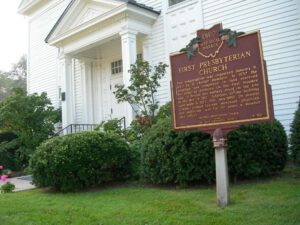
This congregation was organized January 9, 1820 by 11 charter members. In 1837 the structure was completed on land reserved for religious purposes on the first Maumee plat. A British gun battery stood on the site in the War of 1812. Additions to the building were made in 1922, 1951, and 1968. Dr. Horatio Conant, pioneer teacher, merchant, physician, and politician, was for 59 years a member and officer.