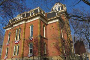
In 1764, Colonel Henry Bouquet established the site of what is now Coshocton. In 1811, the county was founded and the town incorporated as the county seat. The Coshocton County Courthouse, the third on this site, was built between 1873 and 1875 by contractors Carpenter and Williams of Meadville, Pennsylvania. The Second Empire structure features a five-story tower containing a four-faced clock and the bell from the previous 1824 courthouse. The courthouse contains a notable mural by artist Arthur William Woelfle depicting the signing of Bouquet’s treaty with the Indians near the Walhonding River in November 1764. The Coshocton County Courthouse was added to the National Register of Historic Places in 1973.
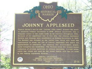
Urbana University was established by the Swedenborgian Church in 1850. Bailey Hall (1853), named after Francis Bailey (1735-1815), was designed by W. Russell West, architect of the Statehouse of Ohio. Bailey was an American Revolutionary War hero, official printer of the Continental Congress and printer of The Freeman’s Journal or the North American Intelligencer. He also printed The True Christian Religion papers. John (Johnny Appleseed) Chapman (1774-1845) distributed The True Christian Religion papers along with his famous apple trees throughout Ohio as a missionary for the Swedenborgian Church. Barclay Hall (1883) was named after Hester Barclay, a ward of Francis Bailey. It was Hester Barclay’s brother-in-law, John Young, who converted Chapman to the Swedenborg faith. Francis Bailey and Hester Barclay were the first male and female Swedenborgian converts in North America. Both Bailey and Barclay halls appear on the National Register of Historic Places.
Originally called St. Clairsville and platted in 1801, Decatur was named for early 19th century naval hero Stephen Decatur. It is among the oldest villages in Brown County, which before 1817 was a part of Adams County. Among its notable early residents were Nathaniel Beasley (1774-1835), the first surveyor of Adams County, and Sarah Boone Montgomery (1763-1848), a heroine of the border wars in Kentucky. Decatur and Byrd Township supported at least four known stations on the Underground Railroad. Many area residents helped conduct escaping slaves northward to freedom.
Hubbard House Underground Railroad Museum, 1603 Walnut Blvd
Ashtabula
, OH
Built in the 1840s by William and Catharine Hubbard and known as “Mother Hubbard’s Cupboard” or “The Great Emporium” by fugitive slaves, the Hubbard House was an important terminus on the fabled Underground Railroad in the years before the Civil War. The Hubbard House sheltered escaped slaves who had risked life and limb after crossing the Ohio River into the North. From the Hubbard home, slaves walked one-quarter mile to the Hubbard and Company warehouse on the Ashtabula River, where friendly boat captains awaited to ferry their passengers to Canada and freedom. The U.S. Department of the Interior listed the Hubbard House on its National Register of Historic Places in 1973.
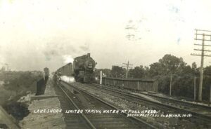
Like many nineteenth century communities in Ohio, Stryker owes its birth and early growth to the railroad industry. Stryker, named for Rome, New York, attorney and railroad executive John Stryker, was surveyed on September 19, 1853, beside the proposed Northern Indiana Railroad. For more than fifty years, “track pans” at Stryker allowed steam locomotives to take on 5,000 gallons of water while traveling at forty to fifty miles per hour, saving valuable time, “the principal enemy of railroad schedules.” On July 23, 1966, the U.S. rail speed record of 183.85 miles per hour was set through Williams County, including through Stryker. The Stryker depot was constructed in 1900 and placed on the National Register of Historic Places on August 7, 1989. (continued on other side)
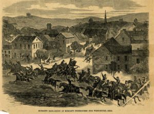
General John Hunt Morgan of Kentucky led a force of Confederate calvarymen into Meigs County during a forty-six day raid north of the Ohio River. The advance forces burned Benjamin Knight’s carding mill and sawmill, the Shade River Bridge, and pillaged local businesses in Chester on July 18, 1863, while waiting for the rest of the column to catch up. This two-hour halt delayed General Morgan’s arrival at the ford at Buffington Island until after dark, allowing Union troops to arrive before he could make his escape. General Morgan surrendered eight days later near West Point in Columbiana County, the northernmost point ever reached by Confederate forces during the Civil War.
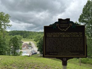
The Exaltation/Elevation of the Holy Cross Church served both Byzantine Greek and Russian Orthodox Catholic congregations from 1915 to 1967. As Slovak migrants found work in the Cambridge coal fields of Guernsey and Noble Counties, they dreamed of a place to worship surrounded by the religious rites and iconography of their homeland. On January 26, 1914, Daniel Varhola, John Fetkovich, John Demko, Stephen Varhola, and Mike Zeleznik (trustees of the “Greek Catholic Church, which is united forever with the Holy Catholic Apostolic Church”) purchased land on a hill overlooking Belle Valley. The two-sided cornerstone, inscribed in Russian and Slovak, was blessed November 15, 1915. For over 50 years, the church anchored the Eastern European immigrants living in Belle Valley to the ethnic identity and traditions of their homeland. (Continued on other side)
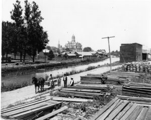
Miami & Erie Canal and Napoleon’s First Cemetery. The Miami & Erie Canal stretched approximately 250 miles from Cincinnati to Toledo. Napoleon and other towns on the Maumee River’s banks were on a slackwater section of the canal. Between 1825 and 1845, laborers constructed the canal using shovels, picks, wheelbarrows, and horse and mule-drawn carts. In Henry County, Napoleon, and elsewhere, German and Irish immigrants and area farmers did the work and were paid around 30 cents a day. As the canal brought more people and business to the area, villages such as Florida, Damascus, and Texas flourished and the county seat of Napoleon boomed. The canal and consequent growth took their tolls, however. Sickness and disease such as “ague” (malaria) and cholera spread and carried off many. Napoleon’s first cemetery was located in the vicinity of 500 East Clinton Street, near the route of the canal.