

, OH
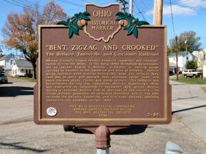
Monroe County’s rugged terrain hindered commerce and communication during the 1800s. In the early 1870s Woodsfield businessmen, led by banker Samuel L. Mooney, promoted a narrow-gauge railroad to connect to the Baltimore and Ohio at Bellaire. Narrow gauge railroads were popular during this boom era because they cost less to build and operate than standard-gauge lines and could traverse sharp curves and steep terrain. The Bellaire and Southwestern Railway was completed through Armstrong’s Mills and Beallsville to Woodsfield in December 1879, giving Monroe County a welcome modern link to the rest of the country. Its initial success prompted its extension westward, and it was soon renamed the Bellaire, Zanesville, and Cincinnati Railway, reaching Zanesville via Caldwell in late 1883.
, OH
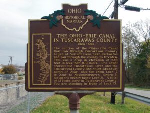
Seeking an alternative transportation route to distant markets, many farmers and manufacturers in Ohio wanted to connect the Ohio River to Lake Erie with a canal. Beginning in Cleveland the Ohio-Erie Canal ran south, the length of the state, to Portsmouth. The canal was a total of 308 miles long, 40 feet wide at the surface, and 4 feet deep. The Ohio-Erie Canal opened for traffic along its entire length in 1832 and consequently effected great change. Population along the canal increased, and commercial, political, and industrial growth in Ohio boomed. Products grown and manufactured in this previously isolated region now had access to world markets. Profits for farmers and merchants increased, and the entire state economy was bolstered. With the rise of railroads in the 1860s, however, canals were destined to become obsolete because the railroad was a faster and more dependable means of transportation. The canal system ceased to operate altogether after a disastrous flood in 1913.
, OH
Evansport is named after brothers Amos and Albert G. Evans who, with Jacob Coy, had the village surveyed next to the Tiffin River on December 14, 1835. The “port” suffix in Evansport’s name reflects the river’s significance as a transportation thoroughfare. Evansport’s early growth was spurred by its mills powered by the Tiffin River. The mills provided settlers with lumber for buildings and supplied flour and cornmeal for sustenance and commerce. Settlers who poured into Williams County’s northern townships in the 1830s agitated debate about moving the county seat to a more centralized location. Evansport was platted as a possible site for the county seat. The Williams County seat was moved to Bryan in 1840 and in 1845 Defiance County was created, leaving Evansport on the Williams-Defiance county line.
, OH
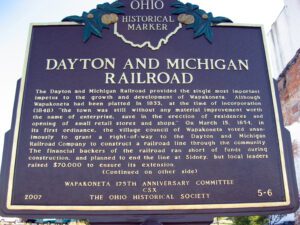
The Dayton and Michigan Railroad provided the single most important impetus to the growth and development of Wapakoneta. Although Wapakoneta had been platted in 1833, at the time of incorporation (1848), “the town was still without any material improvement worth the name of enterprise, save in the erection of residences and opening of small retail stores and shops.” On March 15, 1854, in its first ordinance, the village council of Wapakoneta voted unanimously to grant a right-of-way to the Dayton and Michigan Railroad Company to construct a railroad line through the community. The financial backers of the railroad ran short of funds during construction, and planned to end the line at Sidney, but local leaders raised $70,000 to ensure its extension. (Continued on other side)
, OH
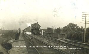
Like many nineteenth century communities in Ohio, Stryker owes its birth and early growth to the railroad industry. Stryker, named for Rome, New York, attorney and railroad executive John Stryker, was surveyed on September 19, 1853, beside the proposed Northern Indiana Railroad. For more than fifty years, “track pans” at Stryker allowed steam locomotives to take on 5,000 gallons of water while traveling at forty to fifty miles per hour, saving valuable time, “the principal enemy of railroad schedules.” On July 23, 1966, the U.S. rail speed record of 183.85 miles per hour was set through Williams County, including through Stryker. The Stryker depot was constructed in 1900 and placed on the National Register of Historic Places on August 7, 1989. (continued on other side)
, OH
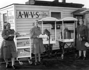
The Lima Chapter of the American Women’s Voluntary Services Organization established a community-based, free canteen during World War II for troops traveling on the Pennsylvania Railroad and adjacent Baltimore & Ohio-Nickel Plate Railroads. Meeting as many as forty trains a day, the ladies served 2.5 million troops between 1942-1945. Food, coffee, and other items were donated to the canteen from a twelve county area. The “AWVS” disbanded in 1945, but succeeding volunteers continued to provide service throughout the Korean Conflict and Viet Nam War. Lima’s “Servicemen’s Free Canteen” was the longest, continuously operated service canteen in the United States. An estimated four million soldiers, sailors, and marines were served between 1942-1970.
, OH
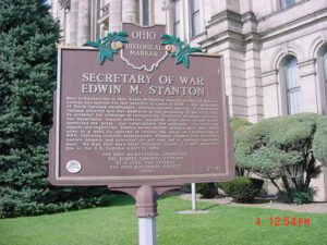
Born in Steubenville in 1814, Edwin McMasters Stanton studied at Kenyon College and opened his law practice in Cadiz in 1836. The grandson of North Carolina slaveholders, Stanton opposed slavery. A successful railroad attorney and War Democrat at the beginning of the Civil War, he accepted the challenge of reorganizing President Abraham Lincoln’s War Department. Stanton enforced unpopular draft laws, fought draft, restricted the press, and nationalized the railroads. An effective planner and logistician, Stanton moved 20,000 soldiers more than 1,200 miles in a week by railroad to relieve the siege of Chattanooga in 1863. Following Lincoln’s assassination, Stanton clashed with President Andrew Johnson and provoked the act that led to Johnson’s impeachment. He died four days after President Ulysses S. Grant appointed him to the U.S. Supreme Court in 1869.
, OH
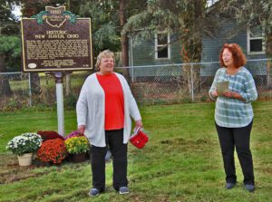
New Haven, Ohio, was the mercantile center of southwest Huron County during the first half of the 19th century. Residents described immense wagons, or “land schooners,” lined up for miles on the New Haven-Worthington Road traveling from Columbus to the Lake Erie ports. Organized in 1815, New Haven was one of the early townships formed in Huron County and the Firelands. The village was platted, with streets at right angles around a diamond-shaped town green, after the plan of New Haven, Connecticut. When, in the 1840s, New Haven rejected the railroad’s direct route through the village, the Sandusky & Newark was routed to the west and through Plymouth taking with it the shipping business. Subsequently, New Haven began a steady economic decline into a small crossroads village.