

, OH
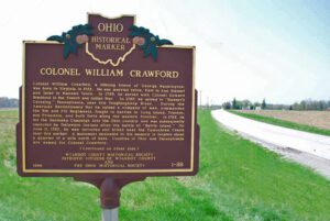
Colonel William Crawford, a lifelong friend of George Washington, was born in Virginia in 1722. He was married twice, first to Ann Stewart and later to Hannah Vance. In 1755, he served with Colonel Edward Braddock in the French and Indian war. In 1767, he moved to “Stewart’s Crossing,” Pennsylvania, near the Youghiogheny River. During the Revolutionary War he raised a company of men, commanded the 5th and 7th Regiments, fought in battles in Long Island, Trenton, and Princeton, and built forts along the western frontier. In 1782, he led the Sandusky Campaign into the Ohio country and was subsequently captured by Delaware Indians after the battle of “Battle Island.” On June 11, 1782, he was tortured and killed near the Tymochtee Creek near this marker. A monument dedicated to his memory is located about a quarter mile north of here. Counties in Ohio and Pennsylvania are named for Colonel Crawford.
, OH
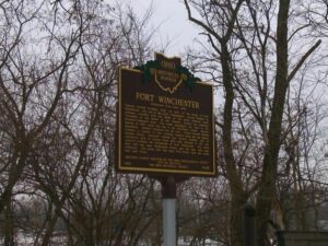
General William Henry Harrison ordered the construction of Fort Winchester at the beginning of October 1812 and it was completed October 15. The fort served as a forward observation post and supply depot for the American army during the War of 1812. Until Fort Meigs was completed in 1813, Fort Winchester was the front line against the British and their Indian allies. During the siege of Fort Meigs, Fort Winchester was a rendezvous point for the troops of General Green Clay and those of Colonel William Dudley. Fort Winchester outlined the shape of a parallelogram, measuring 600 by 300 feet in size. Blockhouses anchored the four corners of the fort and within its stockade were storehouses and a hospital.
, OH
During the Indian Wars of 1790-1795, the United States built a chain of forts in the contested area of what is today western Ohio. These forts were built as a result of various tribes of the region attacking the encroaching American population as they moved north of the Ohio River. In October 1791, General Arthur St. Clair, governor of the Northwest Territory, set out on a mission to punish the tribes and on October 12, ordered his forces to build Fort Jefferson, the fourth link in that chain of forts stretching north from Fort Washington (Cincinnati) to Fort Deposit (Waterville). Each fort was generally a hard day’s march of each other, and the site was chosen because of nearness to a supply of fresh water. The fort was named in honor of Secretary of State Thomas Jefferson.
, OH
In 1769, Pierre-Louis de Lorimier (Peter Loramie) traveled from Canada to this vicinity to establish fur trading with the local indigenous tribes. This location is a portage between tributaries of the Ohio River and Lake Erie that eased the transport of the quantity of furs in this lucrative trade. His very profitable trading post was located just west of this marker along Loramie Creek. Lorimier’s friendship with the local Shawnee and Delaware tribes, and the British, led him to join them in efforts to curtail the movement of white settlers into the Northwest Territory. In 1782, in an attempt to halt raids along the Ohio River (many of which were formulated at Lorimier’s store), General George Rogers Clark ordered Col. Benjamin Logan to burn Lorimier’s store.
, OH
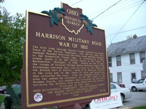
The first road through Marion County followed the Scioto Trail of the Native Americans. This 120-foot wide strip through Wyandot territory led from Lower Sandusky (Fremont) to the Greenville Treaty Line. A confederation of Ohio tribes ceded it to the United States at the Treaty of Brownsville, Michigan, in 1808. During the War of 1812, the troops of General William Henry Harrison’s Army of the Northwest traveled this road en route to Fort Meigs and the British fort at Detroit, using it to transport supplies to the army and to the chain of forts and blockhouses that protected the road. After the American victory, this area was opened for settlement by the 1817 Treaty of the Maumee Rapids, and soldiers who discovered the area while traveling the Military Road were among the first settlers. (continued on other side)
, OH
Unsatisfied by the terms of the treaty that ended the French and Indian War, Ottawa chief Pontiac led a confederacy of Native American tribes in attacks against British frontier forts during 1763, a campaign known as “Pontiac’s Conspiracy.” In October 1764, Colonel Henry Bouquet led a 1500-man army into the Ohio country from Fort Pitt (present-day Pittsburgh) as a demonstration of British force and to free captives held by several tribes. Informed of possible attack, Bouquet diverted his army overland from his Tuscarawas River valley route and here deployed his forces into three lines: a group of scouts on each ridge and the main force along present Route 93. Evidence of artillery emplacements and infantry breastworks remained visible for many years.
, OH
Quincy Adams Gillmore, considered one of the greatest military engineers and artillerists of the Civil War, was born to Quartus Gillmore and Elizabeth Reid Gillmore at this location in 1825. He attended Norwalk Academy and taught high school in Elyria before embarking on a military career. Graduating first in his class at West Point in 1849, he entered the Corps of Engineers. In August 1861, he served in the Union’s Port Royal expedition in South Carolina and later in the reduction of Fort Pulaski, which defended the water approach to Savannah, Georgia. The fort, considered impregnable to artillery, fell to Gillmore’s rifled cannon on April 11, 1862, after a two-day bombardment. His success effectively ended the use of large masonry fortifications. (Continued on other side)
, OH
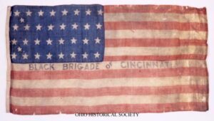
Following the success of Confederate forces in eastern Kentucky and General John Hunt Morgan’s raids there in 1862, Cincinnatians believed that Southern invasion was imminent. Anxious officials ordered Cincinnati citizens to form home guards, but black men willing to volunteer were rebuffed when they attempted to join a defense force. Instead, police serving as provost guards rounded up many and marched them by bayonet to build fortifications in Kentucky. Reacting to the shameful treatment of the blacks eager to support the Union, the commander of the Department of Ohio dispatched Major General Lewis Wallace to command the civilians and to liberate black men forced into service. (continued on other side)